

Wet At Times Through Friday
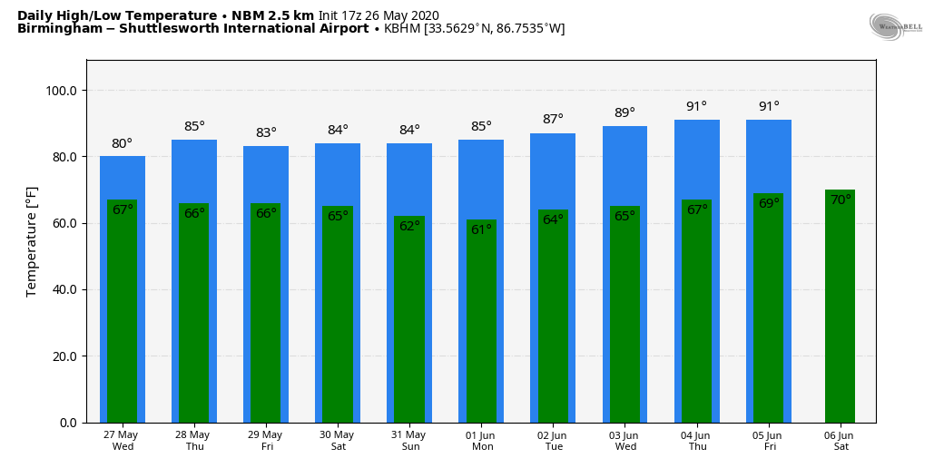
UNSETTLED WEATHER: An upper low over East Texas will drift slowly in our direction in coming days, and will keep an unsettled pattern in place through Friday. This afternoon we have fairly widespread rain over the northern 2/3 of Alabama, and temperatures are only in the low 70s in many areas because of clouds. The average high for Birmingham on May 26 is 84. The air is stable, and we aren’t seeing much lightning. Rain will slowly taper off tonight, but showers could linger after midnight in some spots.
We will forecast periods of rain and a few thunderstorms each day through Friday as the upper low moves in. The rain won’t be continuous, and we will see intervals of sunshine along the way. But the overall pattern is wet, and it is likely that most communities will see 1 to 2 inches of rain.
If sufficient instability can develop, we have the potential for a few strong thunderstorms. SPC has a low end “marginal risk” (level 1/5) of severe thunderstorms for the southern two-thirds of the state tomorrow, and parts of North and East Alabama Thursday.
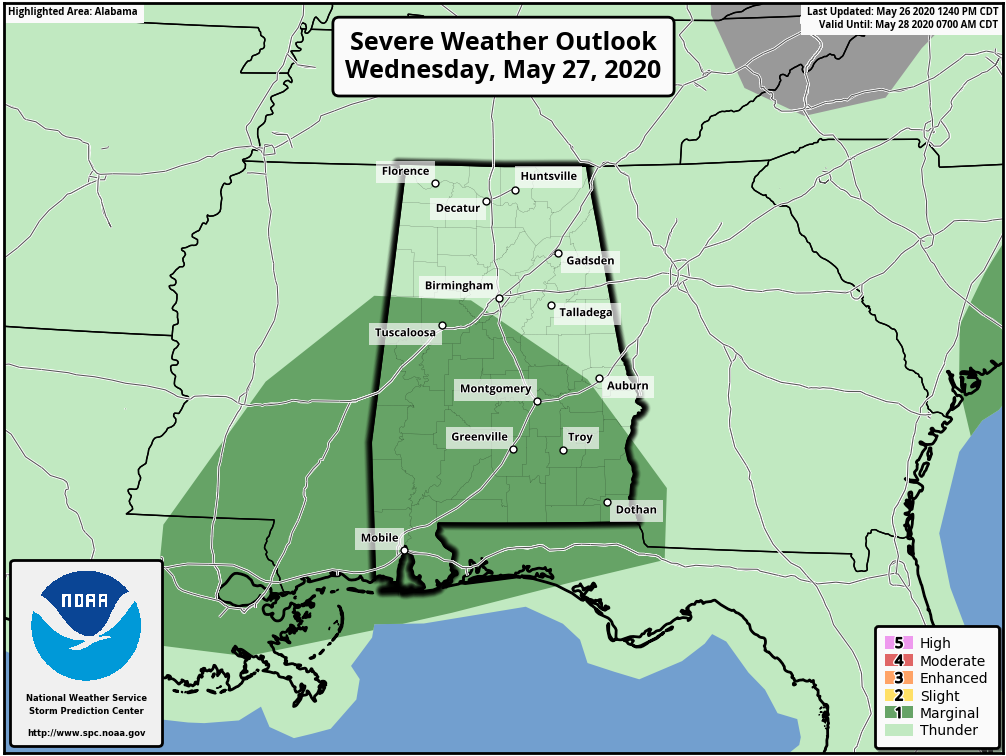
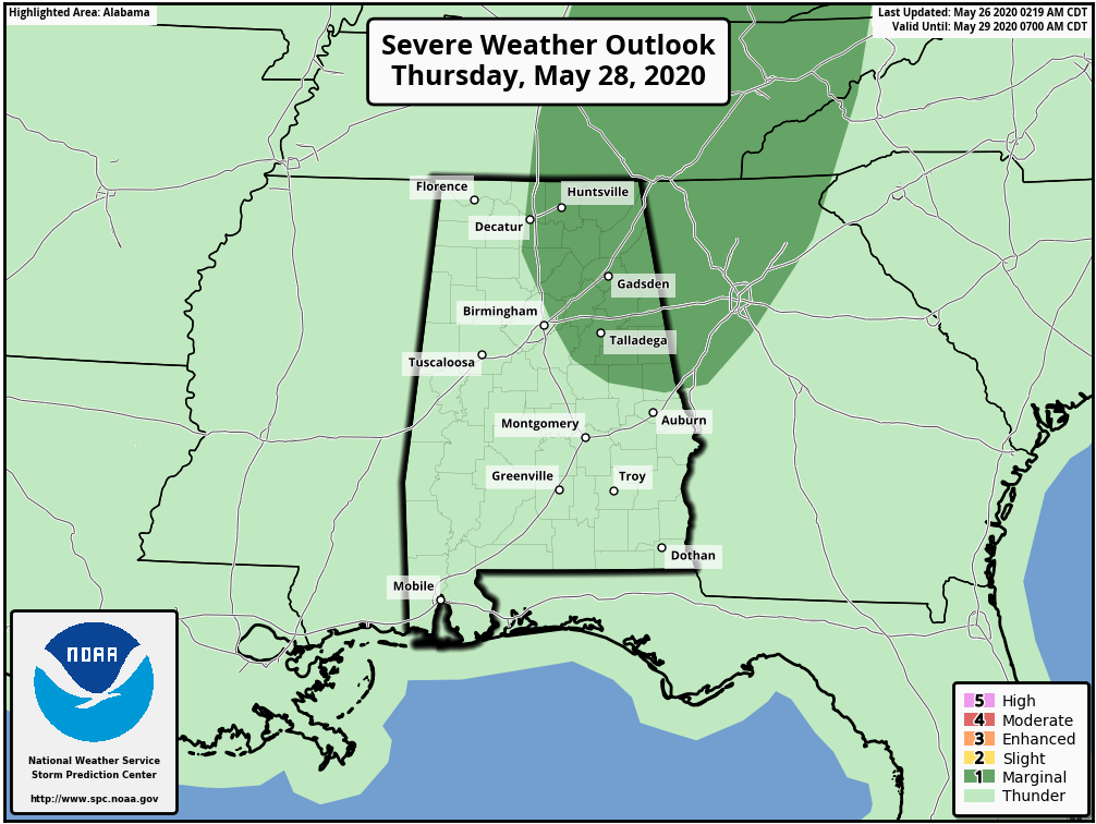
Where stronger storms develop, small hail and strong winds are possible.
THE ALABAMA WEEKEND: A cold front will push through the state Saturday; showers and a few storms remain possible, especially over the eastern and southern counties of the state with a high in the low 80s. Then, a very dry airmass for the end of May drops in here Sunday. The day will feature sunshine in full supply, the humidity will be low, and after a low in the upper 50s, the high will be in the 78-82 degree range… amazingly comfortable for May 31 in Alabama.
NEXT WEEK: Dry weather continues for much of the week with a slow increase in heat and humidity levels. A chance we reach the low 90s by Thursday and Friday… See the Weather Xtreme video for maps, graphics, and more details.
TROPICS: Showers and thunderstorms located over extreme northeastern Florida, adjacent Atlantic waters, and the northwestern Bahamas are associated with an elongated surface trough interacting with an upper-level disturbance. Although a weak surface low has formed within the trough near Orlando, Florida, little if any further development of this system is expected due to land interaction, strong upper-level winds, and an abundance of dry air in the mid-levels of the atmosphere. The broad disturbance is forecast to move northward today and Wednesday, remaining inland or near the coasts of northeastern Florida and Georgia.
Regardless of development, heavy rainfall could cause flash flooding over portions of coastal sections of northeastern Florida and Georgia today, and over portions of the Carolinas on Tuesday and Wednesday. Gusty winds could also produce rough marine conditions and life-threatening surf and rip currents along the coasts of northeastern Florida, Georgia, and the Carolinas through Wednesday.
ON THIS DATE IN 1917: A major tornadic thunderstorm took a 293-mile track across parts of central Illinois and Indiana. Once believed to be a single tornado, the later study indicated it was likely at least eight separate tornadoes. Overall, 101 people in Illinois were killed during the tornado outbreak, with 638 injured.
BEACH FORECAST: Click here to see the AlabamaWx Beach Forecast Center page.
WEATHER BRAINS: Don’t forget you can listen to our weekly 90 minute show anytime on your favorite podcast app. This is the show all about weather featuring many familiar voices, including our meteorologists here at ABC 33/40.
CONNECT: You can find me on all of the major social networks…
Facebook
Twitter
Instagram
Pinterest
Snapchat: spannwx
Look for the next Weather Xtreme video here by 7:00 a.m. tomorrow…
Category: Alabama's Weather, ALL POSTS, Weather Xtreme Videos
About the Author (Author Profile)
James Spann is one of the most recognized and trusted television meteorologists in the industry. He holds the AMS CCM designation and television seals from the AMS and NWA. He is a past winner of the Broadcast Meteorologist of the Year from both professional organizations.Subscribe
If you enjoyed this article, subscribe to receive more just like it.


