

Dry Today; Scattered Storms Return Later This Week
VERY REFRESHING MORNING: On this first day of June temperatures are very comfortable early this morning. Some readings just before daybreak…
Black Creek 49
Cullman 50
Fort Payne 51
Heflin 53
Gadsden 54
Hueytown 54
Weaver 54
Pell City 54
Talladega 56
Decatur 56
Anniston 57
Huntsville 57
Haleyville 58
Northport 60
Tuscaloosa 61
Muscle Shoals 61
Jemison 61
Sylacauga 62
Birmingham 64
Montgomery 66
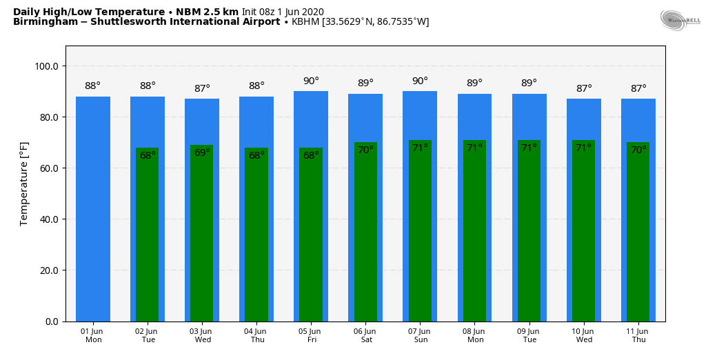
Today will be another mostly sunny day with a high in the 84-87 degree range. Humidity levels will gradually rise in coming days, but most of the state should be dry tomorrow with only isolated afternoon showers.
REST OF THE WEEK: We will bring the chance of “scattered, mostly afternoon and evening showers and thunderstorms” Wednesday through Friday as moisture levels continue to rise. Nothing widespread; odds of any one spot getting wet each day will be in the 30-50 percent range. Otherwise, the sky will be partly sunny with highs mostly in the upper 80s.
THE ALABAMA WEEKEND: We will roll with a persistence forecast. Partly sunny, warm, humid days with random, scattered, mostly afternoon and evening showers and thunderstorms. No way of knowing in advance exactly when and where the showers and thunderstorms will form; you just have to watch radar trends. Highs will be in 87-90 degree range.
NEXT WEEK: We aren’t expecting much change. Highs 87-90; a few scattered storms possible on a daily basis. There will be chances in the placement and coverage of them, but the small scale features responsible for those changes can’t be detected far in advance. Another words, very routine June weather. See the Weather Xtreme video for maps, graphics, and more details.
TROPICS: NHC has upped the chance of tropical development in the far Southwest Gulf of Mexico to 70 percent over the next five days. The remnants of Eastern Pacific Tropical Storm Amanda are currently located inland near the Guatemala-Yucatan Border. This large disturbance is forecast to move slowly northward this morning, followed by a northwestward motion later today, and the center of the low pressure system could emerge over the southeastern Bay of Campeche by this evening. If the remnants move back over water, environmental conditions appear conducive to support some development, and a new tropical depression could form while the system moves little through the middle of this week.
Looking at long range computer model ensemble output, the higher probabilities of impact in 7 days are over either the Texas or Louisiana coasts. Of course, there is no way of knowing right now exactly where this system winds up, or the intensity. We will be keeping a close eye on it.
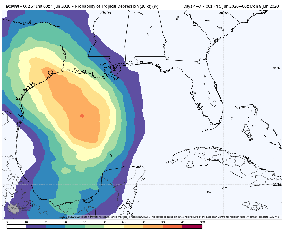
CENTRAL GULF COAST: While the tropical system in the Gulf most likely won’t make landfall on the Alabama or Northwest Florida coast, these areas will be on the eastern, onshore flow side of the system. It will most likely bring a higher coverage of showers and storms to the Central Gulf Coast late this week and over the weekend. But, I will believe you will see sun at times, and the rain certainly won’t be continuous. We will be able to be much more specific once the system develops in a few days.
ON THIS DATE IN 1934: June started off on a warm note as high temperatures surpassed the century mark across parts of the Midwest. Several locations tied or set a record high temperatures for June including: Rockford, IL: 106°, Mather, WI: 105°, Hatfield, WI: 103°, Mondovi, WI: 102°, Chicago, IL: 102° and Grand Rapids, MI tied their June record high with 102°.
BEACH FORECAST: Click here to see the AlabamaWx Beach Forecast Center page.
WEATHER BRAINS: Don’t forget you can listen to our weekly 90 minute show anytime on your favorite podcast app. This is the show all about weather featuring many familiar voices, including our meteorologists here at ABC 33/40.
CONNECT: You can find me on all of the major social networks…
Facebook
Twitter
Instagram
Pinterest
Snapchat: spannwx
Look for the next Weather Xtreme video here by 4:00 this afternoon… enjoy the day!
Category: Alabama's Weather, ALL POSTS, Weather Xtreme Videos
About the Author (Author Profile)
James Spann is one of the most recognized and trusted television meteorologists in the industry. He holds the AMS CCM designation and television seals from the AMS and NWA. He is a past winner of the Broadcast Meteorologist of the Year from both professional organizations.Subscribe
If you enjoyed this article, subscribe to receive more just like it.


