

Mostly Dry Today; Scattered Showers/Storms Tomorrow
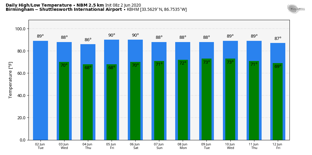
WARM JUNE WEATHER: We are forecasting a high in the upper 80s for most Alabama communities today. The sky will be partly sunny, and the best chance of scattered showers this afternoon will be found over the southern third of the state. The average high for Birmingham on June 2 is 85.
Moisture levels will rise through the rest of the week, and we will bring in the chance of scattered showers and thunderstorms on a daily basis. Most of them, but not necessarily all, will come from about 1:00 until 9:00 p.m.. and odds of any one spot getting wet will be in the 30-40 percent range. Otherwise, look for a mix of sun and clouds each day with highs in the mid to upper 80s.
THE ALABAMA WEEKEND: Not much change; typical early June weather should continue with warm, humid conditions and scattered showers and storms. There could be an increase in the number of showers Sunday, depending on the track of the tropical system in the Gulf of Mexico. The sun will be out at times and highs will be in the 80s.
NEXT WEEK: Again, our weather will be dependent on the tropical situation; if the system moves into Louisiana, or Southeast Texas (as it appears now), deeper tropical moisture will be pulled up into our state early in the week which could set the stage for enhanced rain chances. Otherwise, the week will be warm and muggy with a mix of sun and clouds daily along with the continued threat of scattered showers and thunderstorms. See the Weather Xtreme video for maps, graphics, and more details.
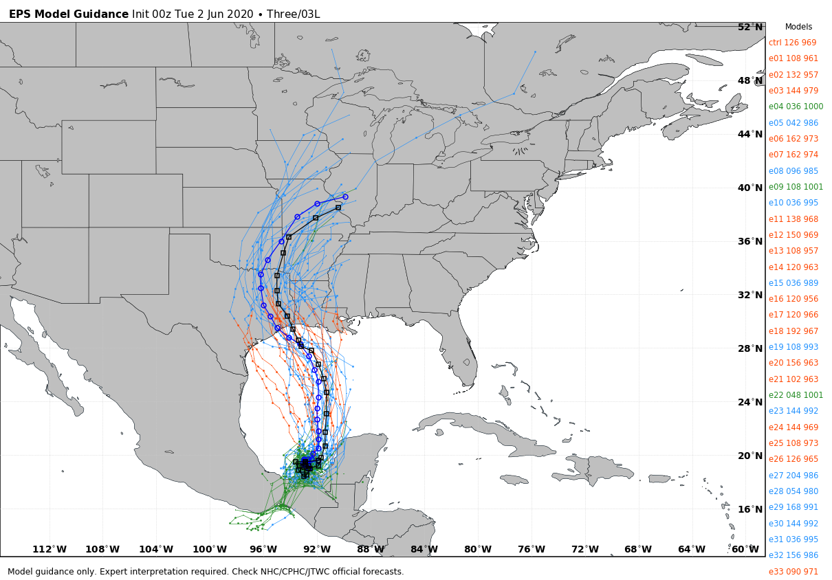
TROPICAL DEPRESSION THREE: The third tropical depression of the Atlantic season developed late yesterday over the Bay of Campeche in the far Southwest Gulf of Mexico. It is expected to become Tropical Storm Cristobal today, and it will move very little over the next 48 hours. The system will then be pulled northward this weekend, and NHC forecasts the center to be over the southern Gulf of Mexico by Saturday night.
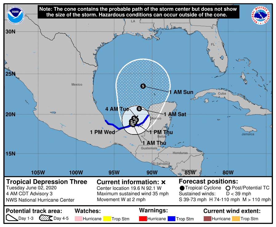
From there, higher landfall probabilities remain centered over the upper Texas and western Louisiana coast Sunday night or Monday, possibly as a hurricane. Of course, at this point, there is no skill in forecasting a specific landfall point or the intensity of the system. Typically the biggest threat from early season systems like this involves heavy rain and flooding.
THE ALABAMA/NORTHWEST FLORIDA GULF COAST: While the direct impact from Cristobal is likely to be west of Alabama and the Florida Panhandle, the Central Gulf Coast will remain on the wet, east side of the system with an onshore flow. Deep tropical moisture will be pulled into the region, leading to higher rain chances by the end of this week and the weekend ahead. The rain could be heavy at times. For now, we are not expecting any dangerous weather in terms of wind, but rip currents will be likely.
Many are asking if they need to cancel their beach trip this weekend. If it was me, I could not cancel. The rain won’t be continuous, and the sun should break out at times. But, different people go to the beach for different reasons of course. I should also mention the track of the tropical system is not “carved in stone” at this point”, and I would certainly pay attention to updates.
ON THIS DATE IN 1998: A tornado touched down at Frostburg, Maryland on June 2, 1998, at 9:45 PM – this was part of a killer outbreak of tornadoes that moved southeast from Pennsylvania. The storm entered Garrett County, Maryland striking the town of Finzel. It then moved up and over Big Savage Mountain in Allegany County and ripped through the northern portion of Frostburg. It reached its peak strength as it crossed the ridge. Winds were estimated between 210 and 250 mph (F4 on the Fujita Tornado Damage Scale). This was the first tornado to “officially” be rated an “F4” in the State of Maryland.
BEACH FORECAST: Click here to see the AlabamaWx Beach Forecast Center page.
WEATHER BRAINS: Don’t forget you can listen to our weekly 90 minute show anytime on your favorite podcast app. This is the show all about weather featuring many familiar voices, including our meteorologists here at ABC 33/40.
CONNECT: You can find me on all of the major social networks…
Facebook
Twitter
Instagram
Pinterest
Snapchat: spannwx
Look for the next Weather Xtreme video here by 4:00 this afternoon. Enjoy the day!
Category: Alabama's Weather, ALL POSTS, Weather Xtreme Videos
About the Author (Author Profile)
James Spann is one of the most recognized and trusted television meteorologists in the industry. He holds the AMS CCM designation and television seals from the AMS and NWA. He is a past winner of the Broadcast Meteorologist of the Year from both professional organizations.Subscribe
If you enjoyed this article, subscribe to receive more just like it.


