

Scattered Showers/Storms Return Tomorrow; Eyes On The Gulf
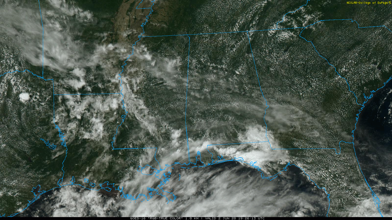
WARM AFTERNOON: Most of Alabama is dry and warm this afternoon with a partly sunny sky along with temperatures in the mid to upper 80s. Showers are confined to the far southern part of the state, and even there they are widely spaced.
Tonight will be mostly fair; the low early tomorrow will be close to 70 degrees.
TOMORROW THROUGH FRIDAY: Moisture levels rise, and we will bring back the chance of scattered showers and thunderstorms on a daily basis. Most, but not necessarily all, of the showers, will come from about 1:00 until 9:00 p.m. Chance of any one spot getting wet each day will be in the 40-50 percent range. Otherwise, expect a mix of sun and clouds with highs mostly in the 84-88 degree range. No way of knowing in advance exactly when and where the storms fire up; you will have to watch radar trends if you have something planned outside.
THE ALABAMA WEEKEND: Not much change Saturday… it will be a warm, humid day with the potential for a few scattered showers and storms. Coverage of showers and storms will likely increase Sunday as tropical moisture surges northward. Highs will be in the 80s.
NEXT WEEK: Monday will be a very humid day with scattered to numerous showers and storms as a tropical system moves northward, west of Alabama. Then, showers will thin out and be more scattered in nature each day for the rest of the week with partly sunny days. Highs through the week will remain mostly in the mid to upper 80s, very close to seasonal averages. See the Weather Xtreme video for maps, graphics, and more details.
TROPICAL STORM CRISTOBAL: The storm has winds of 40 mph, and will meander around in the Bay of Campeche, the far Southwest Gulf of Mexico, through Thursday. Then, it moves northward, and NHC places the center south about 250 miles south of the Louisiana coast Sunday morning.
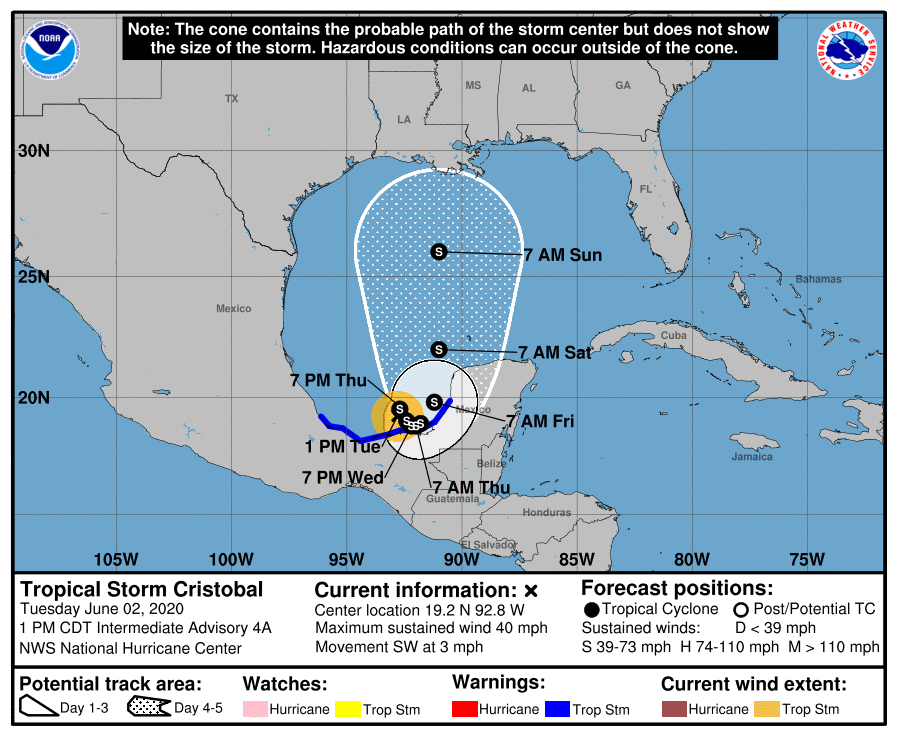
New model guidance suggests the highest landfall probabilities will be on the Louisiana coast late Sunday or Sunday night. It is still too early to forecast a specific landfall point, or the intensity of the storm when it moves onshore. Some chance it becomes a minimal hurricane by the time it reaches land. Heavy rain and flooding are the main threats for most early-season systems like this one. The remnant circulation will move northward through Louisiana Monday, and Alabama will be on the wet, east side of the circulation. This should give our state enhanced rain coverage Sunday and Monday.
THE ALABAMA/NORTHWEST FLORIDA GULF COAST: For places like Gulf Shores, Destin, and Panama City Beach, look for a mix of sun and clouds each day through Saturday with a few passing showers or storms from time to time. Cristobal will pull deeper tropical moisture into the coastal region Sunday and Monday, when periods of rain and a few thunderstorms are likely. Rain could be heavy at times, and some flooding is not totally out of the question with this stretch of the Gulf Coast on the east side of the circulation of the tropical storm. Showers will thin out by Tuesday and Wednesday of next week with increasing amounts of sunshine.
While it will be breezy, wind won’t be a serious threat based on the current forecast track. Dangerous rip currents are likely over the weekend and on Monday. Understand different people go to the beach for different reasons. I would not hesitate to go to the Alabama or Northwest Florida coast this weekend or early next week, but you have to make your own decision. And, of course, keep an eye on the forecast for any potential changes in coming days. Always work with current information.
ON THIS DATE IN 1998: A tornado touched down at Frostburg, Maryland on June 2, 1998, at 9:45 PM – this was part of a killer outbreak of tornadoes that moved southeast from Pennsylvania. The storm entered Garrett County, Maryland striking the town of Finzel. It then moved up and over Big Savage Mountain in Allegany County and ripped through the northern portion of Frostburg. It reached its peak strength as it crossed the ridge. Winds were estimated between 210 and 250 mph (F4 on the Fujita Tornado Damage Scale). This was the first tornado to “officially” be rated an “F4” in the State of Maryland.
BEACH FORECAST: Click here to see the AlabamaWx Beach Forecast Center page.
WEATHER BRAINS: Don’t forget you can listen to our weekly 90 minute show anytime on your favorite podcast app. This is the show all about weather featuring many familiar voices, including our meteorologists here at ABC 33/40.
CONNECT: You can find me on all of the major social networks…
Facebook
Twitter
Instagram
Pinterest
Snapchat: spannwx
Look for the next Weather Xtreme video here by 7:00 a.m. tomorrow…
Category: Alabama's Weather, ALL POSTS, Weather Xtreme Videos
About the Author (Author Profile)
James Spann is one of the most recognized and trusted television meteorologists in the industry. He holds the AMS CCM designation and television seals from the AMS and NWA. He is a past winner of the Broadcast Meteorologist of the Year from both professional organizations.Subscribe
If you enjoyed this article, subscribe to receive more just like it.


