


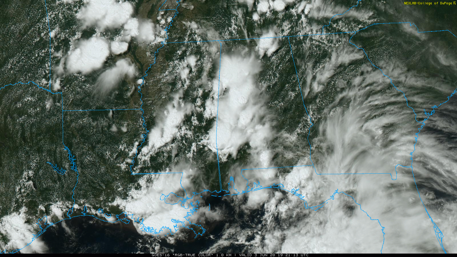
RADAR CHECK: As advertised this morning, scattered showers and thunderstorms have returned to Alabama this afternoon. So far, they have been mostly on the western side of the state, where temperatures have cooled into the 70s. East Alabama is relatively dry with upper-80s in most spots. Showers and storms will slowly fade late tonight.
TOMORROW/FRIDAY: Not much change in our weather. Warm, humid days with a mix of sun and clouds along with scattered showers and thunderstorms. Highs will remain in the mid to upper 80s.
THE ALABAMA WEEKEND: The overall pattern will stay the same, but precipitable water values will be a bit higher as the tropical storm nears the Gulf Coast. We will see some sun Saturday and Sunday, but a passing shower or storm is a pretty good possibility from time to time. No way of knowing in advance exactly where they will form; odds of any one spot getting wet will be in the 40-60 percent range both days. Highs will be mostly in the mid-80s.
NEXT WEEK: A humid, tropical airmass will continue across the state for the week, meaning the continued chance of scattered showers and thunderstorms on a daily basis. Most of the showers (but not all) will come during the afternoon and evening hours. Days will feature a mix of sun and clouds with highs in the mid to upper 80s. See the Weather Xtreme video for maps, graphics, and more details.
TROPICAL STORM CRISTOBAL: The center of Tropical Storm Cristobal is now inland near Ciudad Del Carmen Mexico, and slowly weakening. Sustained winds are 50 mph, and the system should weaken into a tropical depression tomorrow. Then, it begins to move northward Friday and should regain tropical storm strength over the Gulf of Mexico. The latest forecast track from NHC continues to show landfall along the Louisiana Gulf Coast Sunday evening as an upper-end tropical storm.
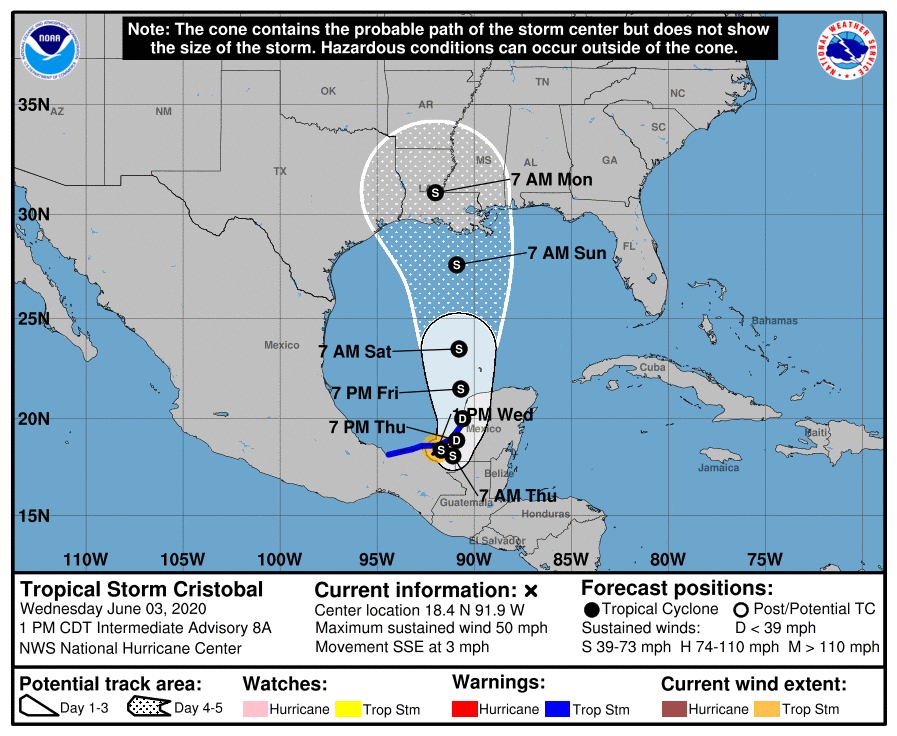
The circulation will move through western Louisiana Monday while weakening. The main threat from Cristobal will be heavy rain and potential flooding. A flash flood watch is now in effect for Southeast Louisiana and the Mississippi Gulf Coast.
ALABAMA/NORTHWEST FLORIDA GULF COAST: Here is a look at the projected impact for the Gulf Coast, from Dauphin Island east to Panama City Beach…
*The weather on the coast will feature about 3 to 5 hours of sunshine tomorrow and Friday with a passing shower or storm from time to time. Showers and thunderstorms become more numerous over the weekend as Cristobal approaches. But, the rain won’t be continuous, and you will probably see a few intervals of sunshine Saturday and Sunday.
*Dangerous rip currents are likely from now through Sunday.
*The rain along the coast could be heavy at times Sunday and Sunday night; rain amounts of 2-4 inches are likely, and some flooding issues could develop.
*A few isolated waterspouts or brief tornadoes are possible Sunday.
*Sustained winds of 15-30 mph are likely on the Alabama Gulf Coast Sunday and Sunday night, speeds of 15-25 mph are likely along the NW Florida coast. The higher wind velocities associated with Cristobal will be to the west, over the Mississippi coast, and Southeast Louisiana.
*Showers thin out after Monday, with increasing amounts of sunshine, But scattered storms will remain possible through the week; you have that chance just about every day in summer on the coast.
For those asking if they need to cancel a beach trip, understand different people go to the beach for different reasons. I would not hesitate to go.
This impact forecast is based on the current forecast track and intensity. Understand this can change; always work with the latest forecast information when making decisions.
ON THIS DATE IN 1993: Early morning severe thunderstorms dumped huge hailstones across northern Oklahoma. Hail, up to 6 inches in diameter in Enid, went through roofs of homes, damaged three jets at Vance Air Force Base, and did $500,000 in damage at a car dealership. Winds gusts reached 70 mph at Vance Air Force Base as well. Hail damage to the wheat crop was estimated at 70 million dollars.
BEACH FORECAST: Click here to see the AlabamaWx Beach Forecast Center page.
WEATHER BRAINS: Don’t forget you can listen to our weekly 90 minute show anytime on your favorite podcast app. This is the show all about weather featuring many familiar voices, including our meteorologists here at ABC 33/40.
CONNECT: You can find me on all of the major social networks…
Facebook
Twitter
Instagram
Pinterest
Snapchat: spannwx
Look for the next Weather Xtreme video here by 7:00 a.m. tomorrow…


