

CANCELED: Severe T-Storm Warning for Winston Co. Until 6:00 pm
The National Weather Service in Birmingham has issued a
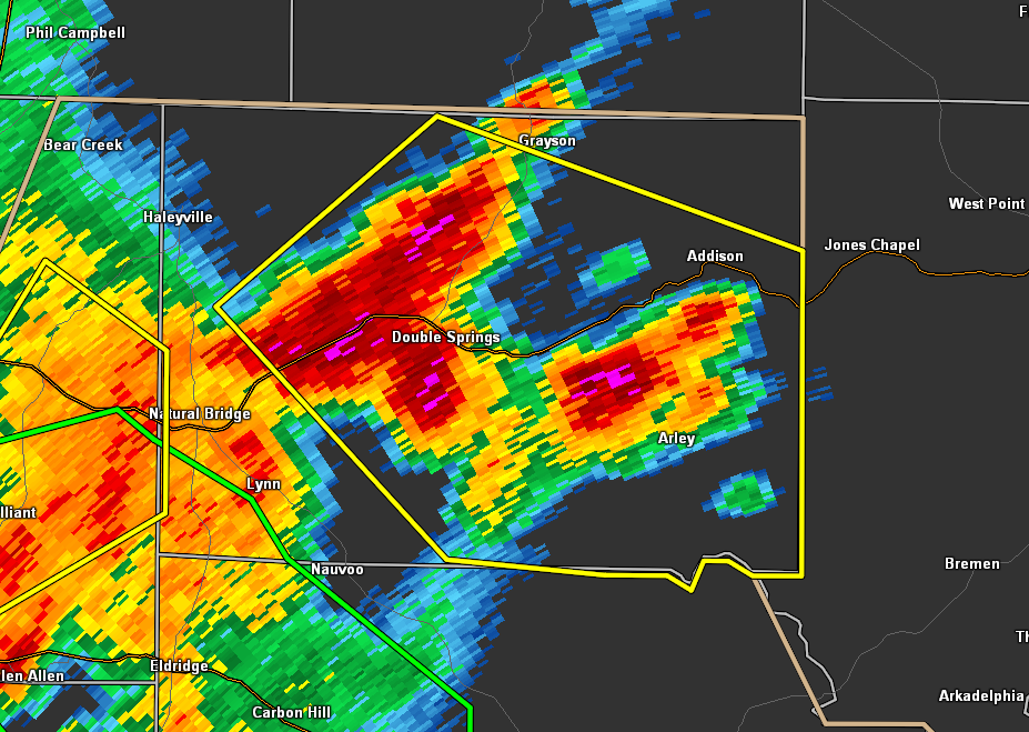
* Severe Thunderstorm Warning for…
Winston County in northwestern Alabama…
* Until 600 PM CDT.
* At 510 PM CDT, a severe thunderstorm was located near Corinth Rec
Area, or near Arley, moving southeast at 10 mph.
HAZARD…60 mph wind gusts and quarter size hail.
SOURCE…Radar indicated.
IMPACT…Hail damage to vehicles is expected. Expect wind damage
to roofs, siding, and trees.
* Locations impacted include…
Arley, Double Springs, Addison, Houston Recreational Area, Camp
McDowell, Nesmith, Smith Lake, Poplar Springs, Helicon, Ashridge,
Corinth Rec Area, Falls City, Moreland, Winston Free State Barn,
Houston, Mill Branch, Maple Branch, Hullett Branch, Clear Creek and
Winston County Airport.
PRECAUTIONARY/PREPAREDNESS ACTIONS…
For your protection move to an interior room on the lowest floor of a
building.
If on or near Smith Lake, get away from the water and move indoors
or inside a vehicle. Remember, lightning can strike out to 15 miles
from the parent thunderstorm. If you can hear thunder, you are close
enough to be struck by lightning. Move to safe shelter now! Do not
be caught on the water in a thunderstorm.
Category: Alabama's Weather, ALL POSTS, Severe Weather
About the Author (Author Profile)
Scott Martin is an operational meteorologist, professional graphic artist, musician, husband, and father. Not only is Scott a member of the National Weather Association, but he is also the Central Alabama Chapter of the NWA president. Scott is also the co-founder of Racecast Weather, which provides forecasts for many racing series across the USA. He also supplies forecasts for the BassMaster Elite Series events including the BassMaster Classic.Subscribe
If you enjoyed this article, subscribe to receive more just like it.


