


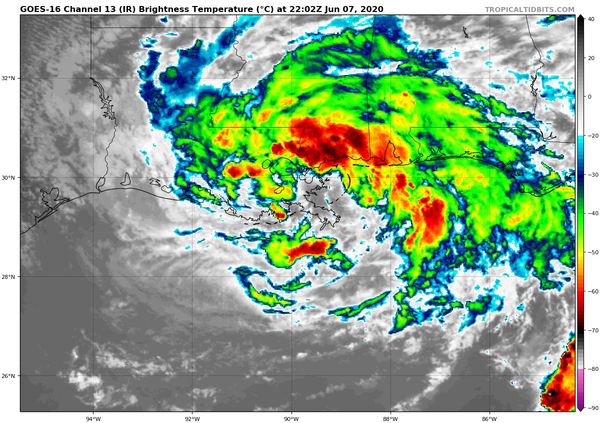
Right at 5:00 pm this evening, the National Hurricane Center reported that Tropical Storm Cristobal made landfall between the mouth of the Mississippi River and Grand Isle, Louisiana. At that time, maximum sustained winds were at 50 MPH and movement was to the north at 7 MPH. The minimum central pressure was at 992 MB or 29.29 inches. A weather station near Gulfport, Mississippi reported sustained winds at 46 MPH and gusts up to 60 MPH. The latest advisory from the NHC has just been released:
SUMMARY OF 700 PM CDT…0000 UTC…INFORMATION
LOCATION…29.6N 89.8W
ABOUT 35 MI…55 KM SSE OF NEW ORLEANS LOUISIANA
MAXIMUM SUSTAINED WINDS…50 MPH…85 KM/H
PRESENT MOVEMENT…N OR 355 DEGREES AT 7 MPH…11 KM/H
MINIMUM CENTRAL PRESSURE…993 MB…29.32 INCHES
WATCHES AND WARNINGS
The Storm Surge Watch along the coast of Louisiana from east of Morgan City to the mouth of the Mississippi River has been discontinued. The Tropical Storm Warning west of Morgan City Louisiana has been discontinued.
A Storm Surge Warning is in effect for…
* Mouth of the Mississippi River to Ocean Springs Mississippi
* Lake Borgne
A Tropical Storm Warning is in effect for…
* Morgan City Louisiana to the Okaloosa/Walton County Florida line
* Lake Pontchartrain and Lake Maurepas
DISCUSSION AND OUTLOOK
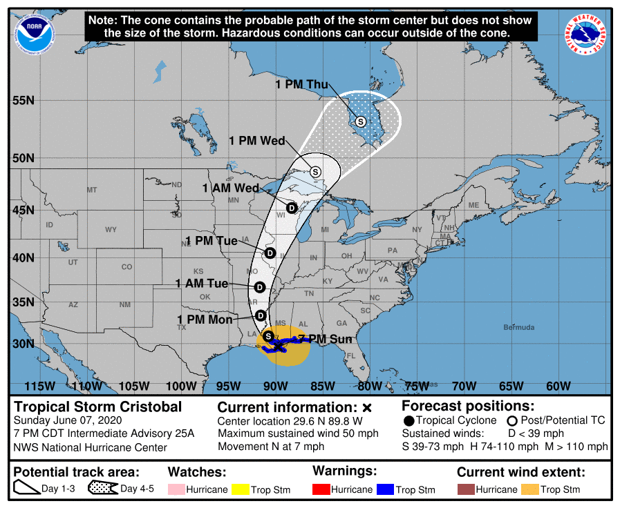
At 700 PM CDT (0000 UTC), the center of Tropical Storm Cristobal was located near latitude 29.6 North, longitude 89.8 West. Cristobal is moving toward the north near 7 mph (11 km/h). A turn toward the north-northwest is expected later this evening and tonight, followed by a northward motion Monday night and Tuesday. On the forecast track, the center of Cristobal will move inland across southeastern Louisiana through Monday morning, and northward across Arkansas and Missouri Monday afternoon into Tuesday.
Maximum sustained winds remain near 50 mph (85 km/h) with higher gusts. Gradual weakening will begin overnight, and Cristobal is forecast to weaken to a tropical depression on Monday.
Tropical-storm-force winds extend outward up to 205 miles (335 km) from the center. An NOAA automated observing station on Dauphin Island, Alabama, recently reported a sustained wind of 45 mph (72 km/h) and a gust to 49 mph (80 km/h), and a Weatherflow site on Ship Island, Mississippi, observed a sustained wind of 37 mph (59 km/h) and a gust to 46 mph (74 km/h).
The estimated minimum central pressure based on nearby surface observations is 993 MB (29.32 inches).
HAZARDS AFFECTING LAND
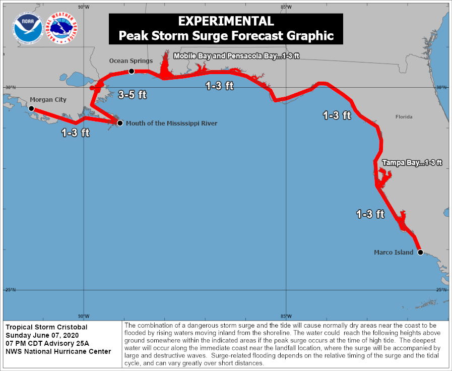
STORM SURGE: The combination of a dangerous storm surge and the tide will cause normally dry areas near the coast to be flooded by rising waters moving inland from the shoreline. The water could reach the following heights above ground somewhere in the indicated areas if the peak surge occurs at the time of high tide…
Mouth of the Mississippi River to Ocean Springs MS including Lake Borgne…3-5 ft
Morgan City LA to Mouth of the Mississippi River…1-3 ft
Ocean Springs MS to Marco Island FL including Mobile Bay, Pensacola Bay, and Tampa Bay…1-3 ft
The deepest water will occur along the immediate coast in areas of onshore winds and will likely extend along the coast well to the east of the center. Surge-related flooding depends on the relative timing of the surge and the tidal cycle and can vary greatly over short distances. For information specific to your area, please see products issued by your local National Weather Service forecast office.
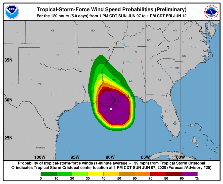
WIND: Tropical storm conditions are expected within the Tropical Storm Warning area along the northern Gulf coast through tonight.
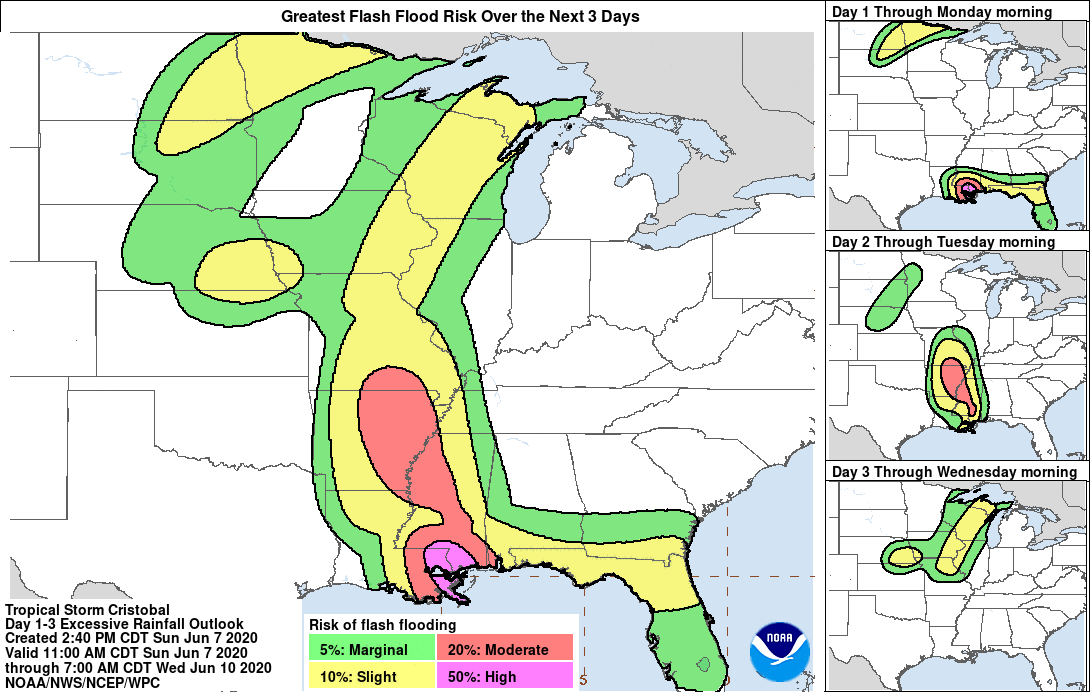
RAINFALL: Cristobal is expected to produce storm total rainfall accumulations of 5 to 10 inches across portions of the central to eastern Gulf Coast into the Lower Mississippi Valley, with isolated amounts to 15 inches. Rainfall totals of 2 to 4 inches with local amounts to 6 inches are expected across portions of the Mid to Upper Mississippi Valley and Northern Plains near and in advance of Cristobal. This rainfall will likely lead to flash flooding and widespread flooding on smaller streams across portions of the central Gulf Coast into the Lower Mississippi Valley. New and renewed significant river flooding is possible along the central Gulf Coast and into the Mississippi Valley.
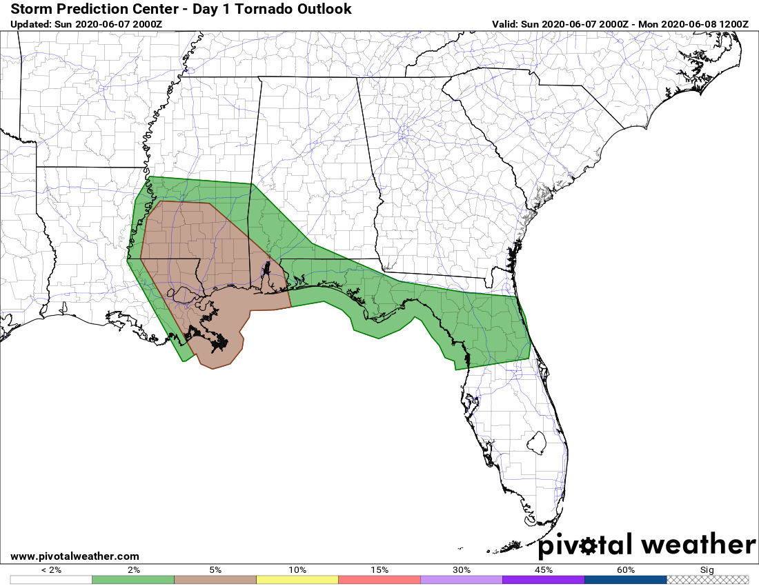
TORNADOES: A few tornadoes are possible tonight across eastern Louisiana, southern Mississippi, southern Alabama, and northern Florida.
SURF: Swells generated by Cristobal will affect portions of the northern and eastern Gulf coast during the next couple of days. These swells are likely to cause life-threatening surf and rip current conditions. Please consult products from your local weather office.
POTENTIAL ISSUES FOR CENTRAL ALABAMA
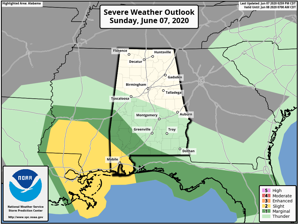
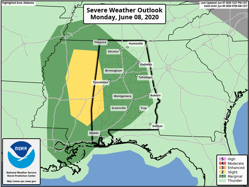
The Storm Prediction Center has included the extreme southwestern parts of Central Alabama in a LEVEL 1 MARGINAL RISK for severe storms for the small potential of a few brief spin-up tropical-type tornadoes and brief isolated wind gusts up to 60 MPH. This goes from now until 7:00 am Monday morning. In effect after 7:00 am through Monday evening, SPC has a LEVEL 2 SLIGHT RISK for severe storms up for the counties in the extreme western parts of Central Alabama mainly along the AL/MS state line, while nearly the rest of the area is under a LEVEL 1 MARGINAL RISK. Once again, the main threat will be for the potential of a few brief spin-up tropical-type tornadoes and isolated damaging wind gusts up to 60 MPH. The main time period for the threat of severe weather will be Monday from 3:00 am to at least 5:00 pm.
As Cristobal continues to trek north-northwest through Louisiana and Mississippi, Central Alabama will be on the wet side of the system. Rain bands have started affecting the extreme southwestern parts of the area and will continue up into the southern half of the area through the night time and overnight hours. Monday now looks to be a pretty wet day at times, especially in the western half of the area. Rainfall will be scattered to numerous in nature, but it will not be an all-day rainout.
We’ll be with you through the entire day on Monday just in case we do see some troublesome weather. I hope you have a great night tonight.


