

Well, Hello Dolly!
BULLETIN
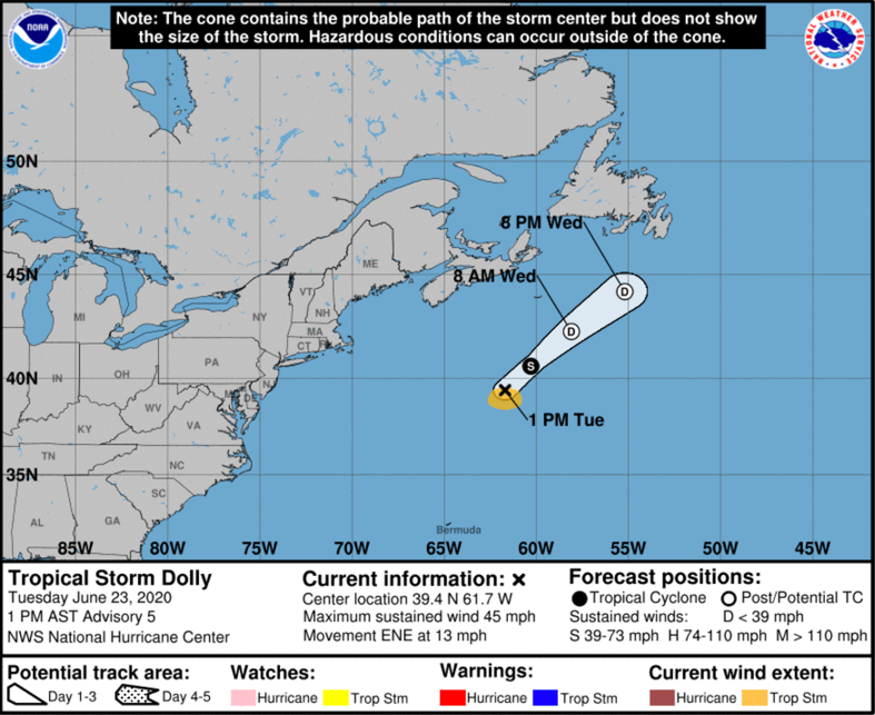
Tropical Storm Dolly Special Advisory Number 5
NWS National Hurricane Center Miami FL AL042020
100 PM AST Tue Jun 23 2020
…DOLLY FORMS OVER THE NORTH ATLANTIC…
…STILL EXPECTED TO BECOME POST-TROPICAL ON WEDNESDAY…
SUMMARY OF 100 PM AST…1700 UTC…INFORMATION
———————————————-
LOCATION…39.4N 61.7W
ABOUT 370 MI…600 KM SSE OF HALIFAX NOVA SCOTIA
ABOUT 665 MI…1070 KM SW OF CAPE RACE NEWFOUNDLAND
MAXIMUM SUSTAINED WINDS…45 MPH…75 KM/H
PRESENT MOVEMENT…ENE OR 65 DEGREES AT 13 MPH…20 KM/H
MINIMUM CENTRAL PRESSURE…1002 MB…29.59 INCHES
WATCHES AND WARNINGS
——————–
There are no coastal watches or warnings in effect.
DISCUSSION AND OUTLOOK
———————-
At 100 PM AST (1700 UTC), the center of Tropical Storm Dolly was
located near latitude 39.4 North, longitude 61.7 West. Dolly is
moving toward the east-northeast near 13 mph (20 km/h). A turn
toward the northeast with an increase in forward speed is expected
tonight and on Wednesday.
Satellite-derived wind data indicate that maximum sustained winds
have increased to near 45 mph (75 km/h) with higher gusts.
Weakening is forecast during the next day or two as Dolly moves
over colder waters, and the system is expected to become
post-tropical on Wednesday. The low should then dissipate by early
Thursday.
Tropical-storm-force winds extend outward up to 70 miles (110 km)
to the south of the center.
The estimated minimum central pressure is 1002 mb (29.59 inches).
HAZARDS AFFECTING LAND
———————-
None.
NEXT ADVISORY
————-
Next complete advisory at 500 PM AST.
$$
Forecaster Berg
About the Author (Author Profile)
Bill Murray is the President of The Weather Factory. He is the site's official weather historian and a weekend forecaster. He also anchors the site's severe weather coverage. Bill Murray is the proud holder of National Weather Association Digital Seal #0001 @wxhistorianSubscribe
If you enjoyed this article, subscribe to receive more just like it.


