

Showers/Storms Fewer In Number Tomorrow
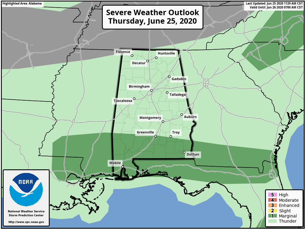
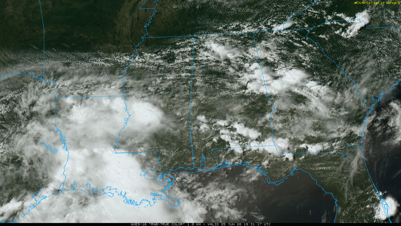
RADAR CHECK: In the moist air across Alabama we have a number of showers and thunderstorms again today… the are moving eastward and are most numerous over the northern, eastern, and southern counties of the state at mid-afternoon. Some of the storms over South Alabama could produce small hail and strong winds; SPC has defined a “marginal risk” (level 1/5) for this part of the state through the evening hours.
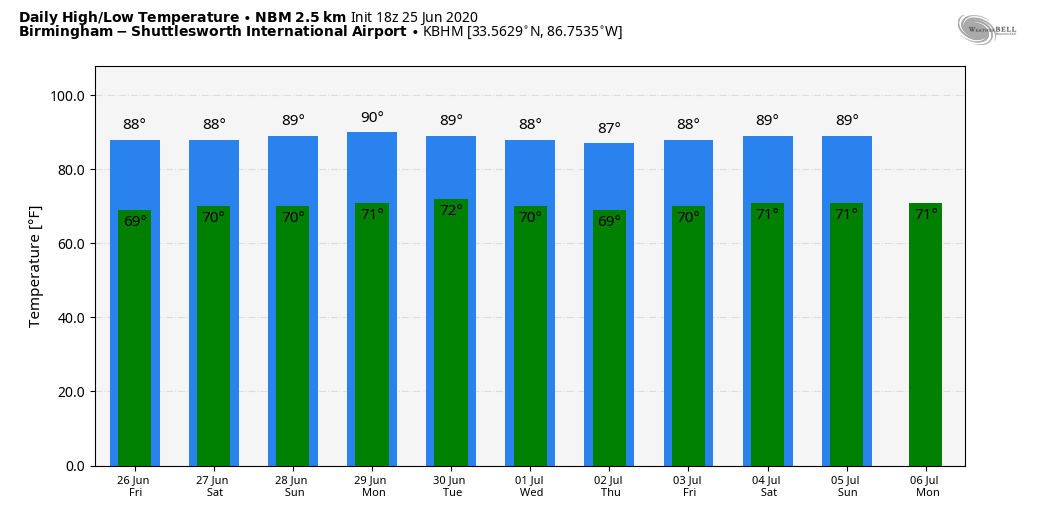
TOMORROW AND THE WEEKEND: The upper trough that has been over the region all week will lift out tonight, and the air should be a little more stable tomorrow through Sunday. This means showers and storms will be more scattered nature, and fewer in number. For each day we expect a partly sunny sky with random, scattered showers and thunderstorms generally between 1:00 and 9:00 p.m. Odds of any one spot getting wet each day will around 40 percent, and highs will be in the mid to upper 80s.
NEXT WEEK: We aren’t expecting much change. Fairly routine late June weather with the risk of pop-up, splash and dash showers and storms during the afternoon and evening hours. Partly sunny days, highs between 86 and 90 most days. See the Weather Xtreme video for maps, graphics, and more details.
TROPICS: The Atlantic basin is quiet, and tropical storm formation is not expected through the weekend.
AFRICAN DUST: The SAL (Saharan Air Layer) has moved up into the Gulf Coast region this morning, and will cover more of Alabama tomorrow and over the weekend. The sky is hazy today in places like New Orleans, Biloxi, and Gulf Shores thanks to the dust, which is mostly several thousand feet off the ground.
This is dry, dusty air that originated over the African continent a couple of weeks ago, and can make the sky rather hazy. There will some reduction in air quality, but it won’t bother most people. The dust will scatter sunlight, bring potential for vivid sunrises and sunsets. This is not unusual, and it happens just about every summer. The size of this SAL is larger than usual, however.
ON THIS DATE IN 1967: Three, F3 tornadoes crossed the Netherlands on this day. The first tornado touched down at 4:17 PM in Oostmalle. This storm destroyed the church and the center of the village. More than half of the 900 homes in the community were damaged with 135 completely gone. The second tornado touched down near Ulicoten and tracked northward through woodlands area. This storm killed two people at a camping site near Chaam, Netherlands. The third tornado destroyed 50 houses in Tricht, killing five and injuring 32 others.
BEACH FORECAST: Click here to see the AlabamaWx Beach Forecast Center page.
WEATHER BRAINS: Don’t forget you can listen to our weekly 90 minute show anytime on your favorite podcast app. This is the show all about weather featuring many familiar voices, including our meteorologists here at ABC 33/40.
CONNECT: You can find me on all of the major social networks…
Facebook
Twitter
Instagram
Pinterest
Snapchat: spannwx
Look for the next Weather Xtreme video here by 7:00 a.m. tomorrow…
Category: Alabama's Weather, ALL POSTS, Weather Xtreme Videos
About the Author (Author Profile)
James Spann is one of the most recognized and trusted television meteorologists in the industry. He holds the AMS CCM designation and television seals from the AMS and NWA. He is a past winner of the Broadcast Meteorologist of the Year from both professional organizations.Subscribe
If you enjoyed this article, subscribe to receive more just like it.


