

Moisture Laden, Tropical Air Continues Over Alabama
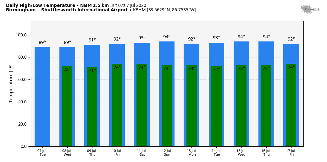
MORE SHOWERS LATER TODAY: The radar is quiet early this morning, but we expect scattered to numerous showers and thunderstorms to form across Alabama this afternoon and tonight in the tropical airmass that covers the state. Odds of any one spot getting wet this afternoon is around 70 percent, and the showers and storms will be very efficient rain producers due to the high precipitable water values. Look for more clouds than sun today with a high in the mid to upper 80s.
Not much change tomorrow; it will be a warm, humid day with a good chance of showers and thunderstorms, especially during the afternoon and evening hours. The high will remain in the 85-89 degree range.
THURSDAY THROUGH THE WEEKEND: While scattered showers and storms are still likely Thursday and Friday, they should be fewer in number as the upper trough over the region lifts out. The sky will be partly sunny both days with highs between 89 and 93 as heat levels begin to tick up. And, for the weekend, we are forecasting a good supply of sunshine Saturday and Sunday with highs mostly in the low 90s, right at seasonal averages for mid-July in Alabama. Afternoon showers and thunderstorms both days will be pretty isolated.
NEXT WEEK: Fairly typical mid-summer weather is the story; partly sunny, hot, humid days with the typical risk of “scattered, mostly afternoon and evening showers and thunderstorms”. Highs through the week will be generally in the 90-84 degree range… See the Weather Xtreme video for maps, graphics, and more details.
TROPICS: An area of low pressure located inland over central Georgia continues to produce a large area of showers and thunderstorms over portions of the southeastern U.S. This system is expected to move generally northeastward toward the coast of the Carolinas and the mid-Atlantic states later this week. Some development of this system is possible late this week if it moves over water. Regardless of development, the low is forecast to produce locally heavy rainfall that could cause flash flooding across portions of the southeastern U.S. during the next couple of days.
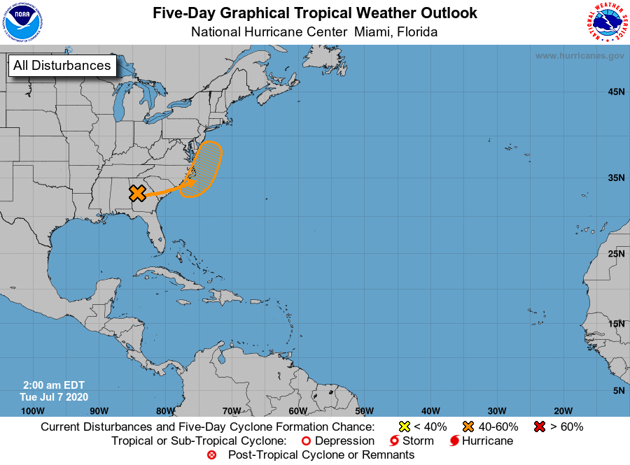
The rest of the Atlantic basin, including the Gulf of Mexico, is quiet.
ON THIS DATE IN 2004: A tornado occurred in the Rockwell Pass area of Sequoia National Park, California. Since the elevation of the tornado’s ground circulation was approximately 3705 m (12,156 ft) MSL, this is the highest-elevation tornado documented in the United States.
BEACH FORECAST: Click here to see the AlabamaWx Beach Forecast Center page.
WEATHER BRAINS: Don’t forget you can listen to our weekly 90 minute show anytime on your favorite podcast app. This is the show all about weather featuring many familiar voices, including our meteorologists here at ABC 33/40.
CONNECT: You can find me on all of the major social networks…
Facebook
Twitter
Instagram
Pinterest
Snapchat: spannwx
Look for the next Weather Xtreme video here by 4:00 this afternoon… enjoy the day!
Category: Alabama's Weather, ALL POSTS, Weather Xtreme Videos
About the Author (Author Profile)
James Spann is one of the most recognized and trusted television meteorologists in the industry. He holds the AMS CCM designation and television seals from the AMS and NWA. He is a past winner of the Broadcast Meteorologist of the Year from both professional organizations.Subscribe
If you enjoyed this article, subscribe to receive more just like it.


