

Muggy with Showers & Storms Exiting; More On The Way

At 12:30 pm: Showers & storms are exiting the area in the east and moving into Georgia while another cluster of storms looks to move into the western and southwestern parts of the area shortly. Temperatures as of the 12:00 pm Round-Up were in the upper 70s to the mid-80s. Birmingham was at 80 degrees with cloudy skies. The warm spot was Troy at 86 degrees with partly sunny skies. Bessemer was the cool spot at 78 degrees with partly sunny skies.
For the rest of the afternoon and into the early evening hours, scattered to numerous showers and thunderstorms will continue to move across the area, especially in the western parts. Not everyone will see rain, but rain chances remain likely in the 60%-70% range. While severe weather is not expected, we may have a brief strong storm or two with gusty winds. Afternoon highs will be in the mid to upper 80s. Showers and storms will continue to be highly possible especially over the southwestern and southern parts of the area. Much of the activity will dissipate as we reach the late-night hours and overnight, but a few lingering showers could remain. Lows will be in the lower to mid-70s.
Thursday will not be much different than today, but we could see a little less in coverage of the shower and thunderstorm activity. Showers and storms remain likely across nearly the entire area, but it will not be an all-day rain and a few locations may end up staying dry. Afternoon highs will be in the upper 80s to right at or just over 90 degrees.
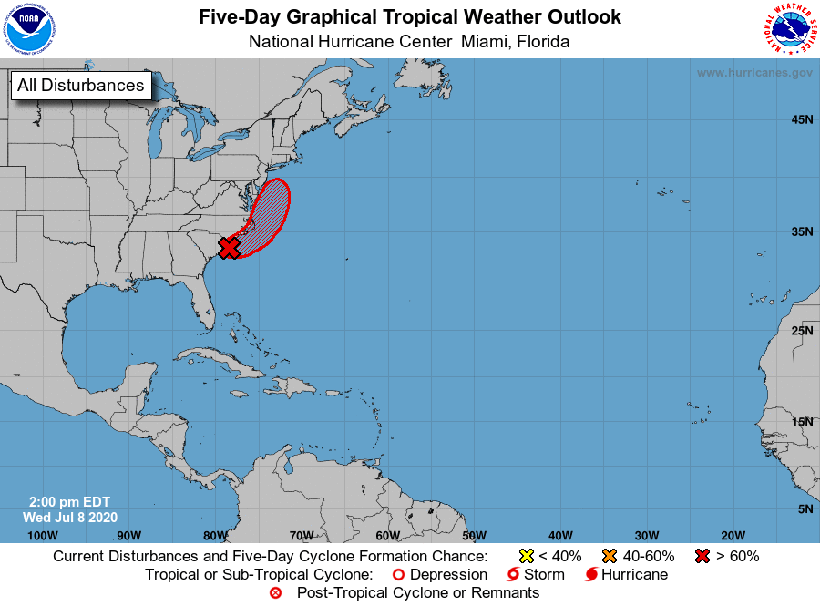
A broad area of low pressure located near the coast of northeastern South Carolina continues to produce a large area of disorganized showers and thunderstorms over the adjacent Atlantic waters and portions of eastern North Carolina. The low is expected to move northeastward near or just offshore of the North Carolina Outer Banks on Thursday, and then turn north-northeastward and move along the mid-Atlantic coast Friday. Environmental conditions are expected to be conducive for development, and a tropical or subtropical cyclone is likely to form within the next day or so. Regardless of development, the system is expected to produce locally heavy rainfall that could cause some flash flooding across portions of eastern North Carolina, the coastal mid-Atlantic, and southern New England during the next few days. Gusty winds are also possible along the North Carolina Outer Banks through Thursday and along the mid-Atlantic and southern New England coasts Friday and Saturday.
Category: Alabama's Weather, ALL POSTS, Tropical
About the Author (Author Profile)
Scott Martin is an operational meteorologist, professional graphic artist, musician, husband, and father. Not only is Scott a member of the National Weather Association, but he is also the Central Alabama Chapter of the NWA president. Scott is also the co-founder of Racecast Weather, which provides forecasts for many racing series across the USA. He also supplies forecasts for the BassMaster Elite Series events including the BassMaster Classic.Subscribe
If you enjoyed this article, subscribe to receive more just like it.


