

Hot, Muggy Summer Weather With Scattered Storms This Afternoon
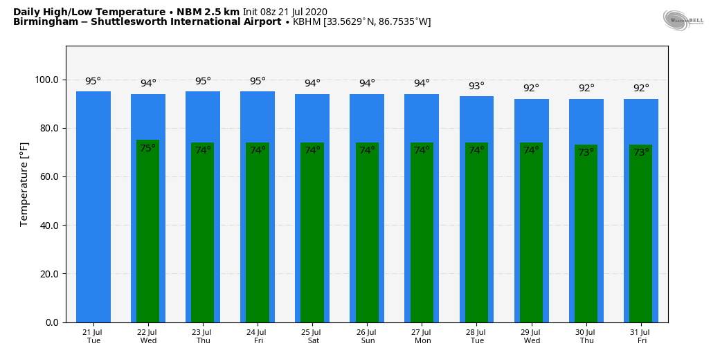
POP UP STORMS LATER TODAY: Nothing is showing up on radar across Alabama early this morning, but later today as the air heats and becomes unstable, look for more random, scattered shower and thunderstorm development, generally between 1:00 and 9:00 p.m. Odds of any one spot getting wet this afternoon will be around 30 percent, and the high will be in the 92-96 degree range for most communities with a mix of sun and clouds. In other words, a very routine summer day for the Deep South.
TOMORROW THROUGH THE WEEKEND: The weather just won’t change much through Sunday. Hot, humid days with “scattered, mostly afternoon and evening showers and thunderstorms”. No way of knowing in advance exactly when and where the storms form; you just watch to watch radar trends if you have something planned outdoors. Most of the storms come from 1:00 until 9:00, during the peak of the heating process. Otherwise, look for partly sunny days with highs in the mid 90s.
NEXT WEEK: Same old story. Classic summer weather continues for the rest of July. Partly sunny, hot, humid days with a few pop up storms around during the afternoon and evening hours. Highs in the 90s, lows in the 70s. Just what you expect this time of the year… See the Weather Xtreme video for maps, graphics, and more details.
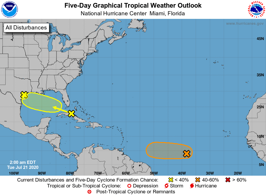
TROPICS: NHC is monitoring three areas this morning. One wave is moving into the Texas coast this morning with no development. Another tropical wave is over Cuba; gradual development of this system is possible while it moves west-northwestward during the next few days. This system is expected to move over the southeastern Gulf of Mexico by late this afternoon, the central Gulf tomorrow, and the northwestern Gulf on Thursday and Friday. An Air Force Reserve Hurricane Hunter aircraft is scheduled to investigate the system this afternoon, if necessary. One way or another this will bring beneficial rain to parts of Texas in 4-5 days, most likely. No direct impact for Alabama or the Central Gulf Coast.
Deeper in the tropics, showers and thunderstorms have increased and become a little better organized in association with a low pressure system located about midway between the west coast of Africa and the Lesser Antilles. Environmental conditions are expected to be somewhat conducive for development, and a tropical depression could form during the next couple of days while the low moves westward at around 10 mph over the tropical Atlantic. By the weekend, however, less favorable conditions should limit additional development.
ON THIS DATE IN 1987: An F4 tornado ravages the Teton Wilderness and Yellowstone National Park in Wyoming. The tornado’s violent winds destroy millions of trees on a 24.3-mile track that traverses the Continental Divide at an elevation of 10,170 feet.
BEACH FORECAST: Click here to see the AlabamaWx Beach Forecast Center page.
WEATHER BRAINS: Don’t forget you can listen to our weekly 90 minute show anytime on your favorite podcast app. This is the show all about weather featuring many familiar voices, including our meteorologists here at ABC 33/40.
CONNECT: You can find me on all of the major social networks…
Facebook
Twitter
Instagram
Pinterest
Snapchat: spannwx
Look for the next Weather Xtreme video here by 4:00 this afternoon… enjoy the day!
Category: Alabama's Weather, ALL POSTS, Weather Xtreme Videos
About the Author (Author Profile)
James Spann is one of the most recognized and trusted television meteorologists in the industry. He holds the AMS CCM designation and television seals from the AMS and NWA. He is a past winner of the Broadcast Meteorologist of the Year from both professional organizations.Subscribe
If you enjoyed this article, subscribe to receive more just like it.


