

Sun, Heat, and Storms
SUN AND STORMS: For some, summer soakers have developed this afternoon with heavy rain, some flooding, gusty winds, and lots of lightning. But, for others, it has been a partly sunny, hot, humid, and dry day. Scattered storms are moving slowly northward, and where rain is falling temperatures are in the 70s. Away from the storms, readings are mostly in the low 90s with very high precipitable water values. Storms will settle down later tonight as the air cools and becomes more stable.
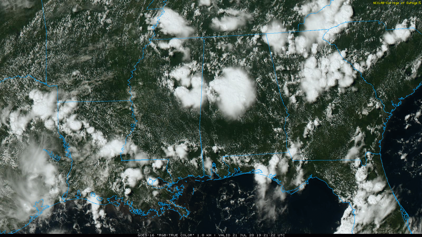
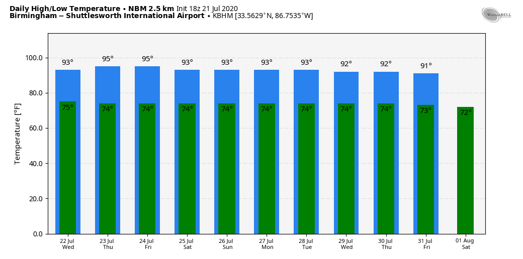
Not much change tomorrow; very humid with scattered showers and storms forming by early afternoon in the unstable air… the high will be in the low 90s for most communities, right at seasonal averages for late July in Alabama.
THURSDAY THROUGH THE WEEKEND: Showers and storms should be fewer in number by Thursday and Friday; odds of any one spot getting wet will be around one in four each afternoon. The sky will be partly sunny with a high between 93 and 96 degrees. And, we don’t expect much change through the weekend as the hot, muggy weather continues. Partly sunny days, a few pop up storms each afternoon to dodge. Classic mid-summer weather for Alabama.
NEXT WEEK: We will roll with the persistence forecast. Partly sunny, hot, humid days with “scattered, mostly afternoon and evening showers and thunderstorms”. Highs will be in the 90s, lows in the 70s. See the Weather Xtreme video for maps, graphics, and more details.
TROPICS: A tropical wave (Invest 99L) in the Atlantic between the coast of Africa and the Windward Islands is now forecast to become a tropical depression tonight. A good chance it becomes Tropical Storm Gonzalo in coming days. Regardless of development during the next couple of days, less favorable conditions should limit additional development of the system by the weekend.
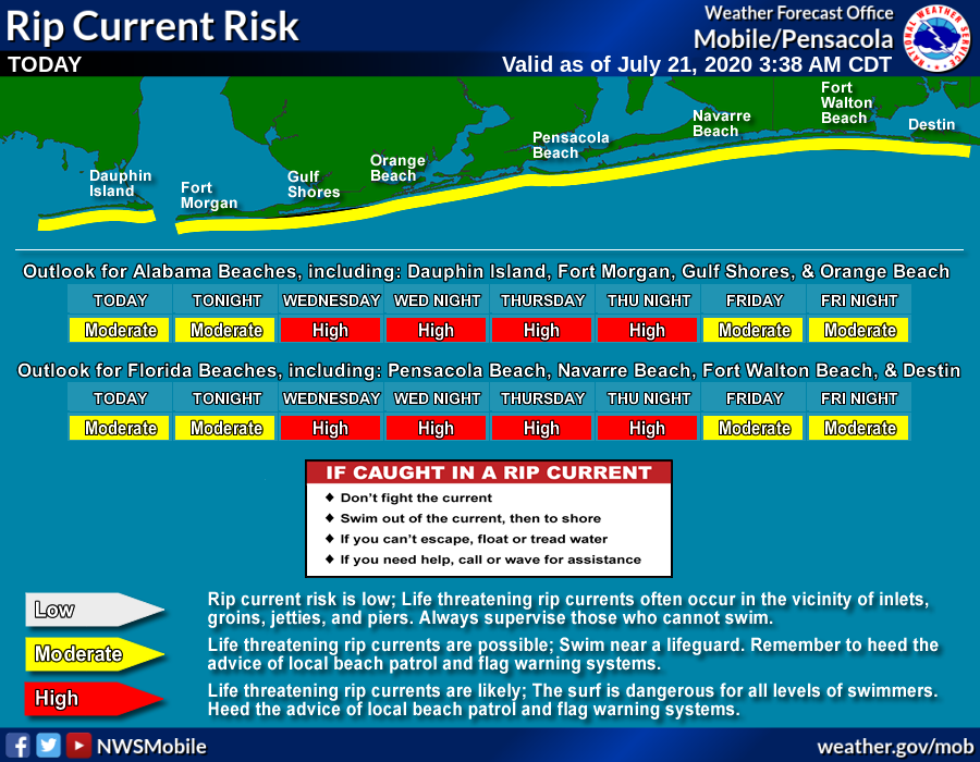
Another wave is in the far southeast Gulf of Mexico (Invest 91L)… this could become a tropical depression in coming days as it moves westward, in the general direction of the Texas Coast. The main impact, most likely, will be heavy rain, and it should remain south of Alabama and the Central Gulf Coast. However, the rip current danger will increase from Gulf Shores over to Panama City Beach beginning tomorrow.
ON THIS DATE IN 1987: An F4 tornado ravages the Teton Wilderness and Yellowstone National Park in Wyoming. The tornado’s violent winds destroy millions of trees on a 24.3-mile track that traverses the Continental Divide at an elevation of 10,170 feet.
BEACH FORECAST: Click here to see the AlabamaWx Beach Forecast Center page.
WEATHER BRAINS: Don’t forget you can listen to our weekly 90 minute show anytime on your favorite podcast app. This is the show all about weather featuring many familiar voices, including our meteorologists here at ABC 33/40.
CONNECT: You can find me on all of the major social networks…
Facebook
Twitter
Instagram
Pinterest
Snapchat: spannwx
Look for the next Weather Xtreme video here by 7:00 a.m. tomorrow…
Category: Alabama's Weather, ALL POSTS, Weather Xtreme Videos
About the Author (Author Profile)
James Spann is one of the most recognized and trusted television meteorologists in the industry. He holds the AMS CCM designation and television seals from the AMS and NWA. He is a past winner of the Broadcast Meteorologist of the Year from both professional organizations.Subscribe
If you enjoyed this article, subscribe to receive more just like it.


