

Scattered Storms This Afternoon; Tropical Depression In The Gulf
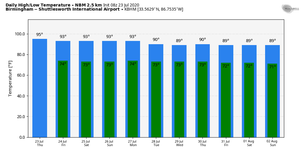
CLASSIC SUMMER WEATHER CONTINUES: The overall weather situation won’t change much for Alabama through the weekend. An upper ridge will remain parked over the southern U.S… meaning partly sunny, hot, humid days with “scattered, mostly afternoon and evening showers and thunderstorms” on a daily basis. Most of them will come from about 1:00 until 9:00 p.m… and odds of any one spot getting wet will remain around 30 percent through Sunday. Afternoon highs will be between 91 and 95 degrees for most communities. Just what you expect in late July around here.
NEXT WEEK: Not much change Monday, but we still see evidence that showers and thunderstorms will become more numerous by Tuesday and through the middle of the week as moisture levels rise, and the air aloft becomes colder making for higher instability values. Highs will drop into the upper 80s and low 90s due to the increase in showers. See the Weather Xtreme video for maps, graphics, and more details.
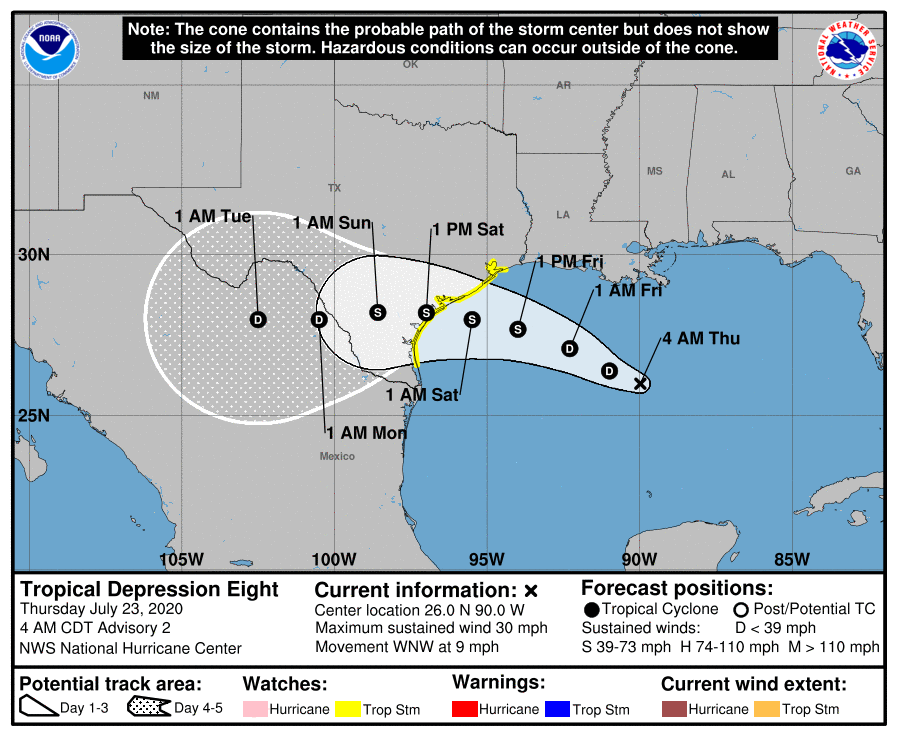
TROPICAL DEPRESSION EIGHT: A new tropical depression has formed in the Central Gulf of Mexico; it is moving west toward Texas, and is expected to become Tropical Storm Hanna tonight or tomorrow. A Tropical Storm Watch is in effect from Port Mansfield to High Island Texas; landfall is expected Saturday. The main impact will be heavy rain and potential flooding over parts of South Texas this weekend… no direct impact to Alabama or the Central Gulf Coast other than increased rip current danger.
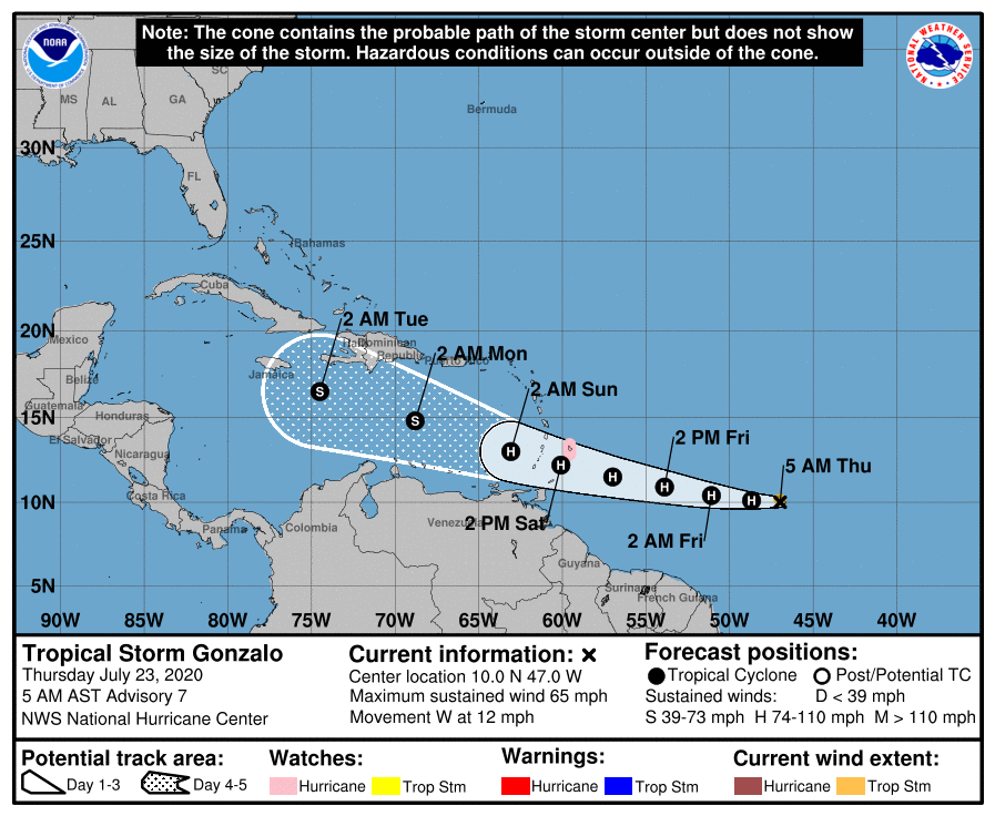
TROPICAL STORM GONZALO: Gonzalo is 970 miles east of the Windward Islands, and is packing sustained winds of 65 mph. It is expected to become a hurricane over the next 24 hours, and will move through the islands and into the Caribbean this weekend. Some weakening is forecast then due to dry air and subsidence (sinking air motion), but it now looks like the system will survive those conditions. Most model ensemble members (but not all) bring it into the Gulf of Mexico in a week or so. Way too early to know if this will impact the U.S… just something to watch for now.
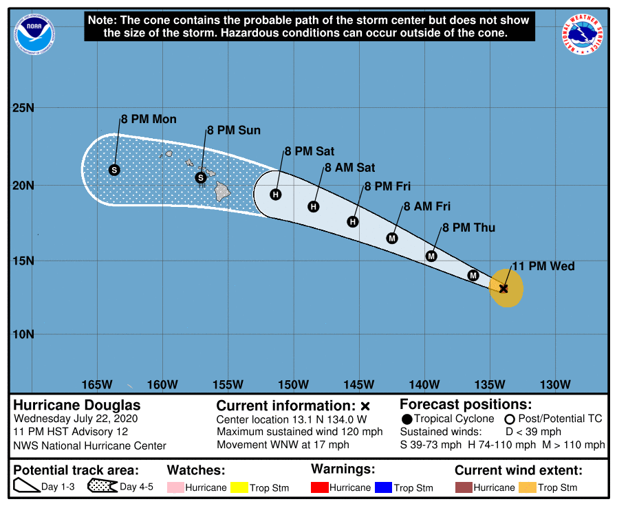
HURRICANE DOUGLAS: And, over in the Pacific Douglas features sustained winds of 120 mph, making it a major hurricane. It is moving toward Hawaii, but thankfully weakening is expected, and the system should be a tropical storm by the time it reaches the islands this weekend; flooding is the main threat.
ON THIS DATE IN 1788: Called the George Washington’s Hurricane, this storm originated near Bermuda on the 19th before making landfall in Virginia. It passed directly over the Lower Chesapeake Bay and Mount Vernon, the home of George Washington. This track is very similar to the path of the Chesapeake-Potomac hurricane of 1933. At Norfolk, winds increased at 5 p.m. on the 23rd with the wind originating from the northeast. At 12:30 a.m., the wind suddenly shifted to the south and “blew a perfect hurricane, tearing down chimneys, fences”.
BEACH FORECAST: Click here to see the AlabamaWx Beach Forecast Center page.
WEATHER BRAINS: Don’t forget you can listen to our weekly 90 minute show anytime on your favorite podcast app. This is the show all about weather featuring many familiar voices, including our meteorologists here at ABC 33/40.
CONNECT: You can find me on all of the major social networks…
Facebook
Twitter
Instagram
Pinterest
Snapchat: spannwx
Look for the next Weather Xtreme video here by 4:00 this afternoon… enjoy the day!
Category: Alabama's Weather, ALL POSTS, Weather Xtreme Videos
About the Author (Author Profile)
James Spann is one of the most recognized and trusted television meteorologists in the industry. He holds the AMS CCM designation and television seals from the AMS and NWA. He is a past winner of the Broadcast Meteorologist of the Year from both professional organizations.Subscribe
If you enjoyed this article, subscribe to receive more just like it.


