

Weather Xtreme: Increased Rain Chances Through Friday; Hanna Gets Ready for Landfall
The Central Alabama Weekend
For your Saturday, we’ll lose the tropical influence of Hanna on our weather pattern and start to see an increase in effects from a mid-level trough start to take over. We’ll continue to be hot and humid but afternoon highs will remain a little lower due to the number of clouds in the sky. Showers and thunderstorms will form during the late morning and persist through the afternoon and evening hours. They will be scattered in nature, so not everyone will see rain. Afternoon highs will be in the lower 90s with heat indices in the 100-105 degree range.
We’ll continue to see the same forecast for your Sunday as scattered afternoon and evening showers and storms will fill parts of the radar image across Central Alabama. Once again, not everyone will see rain, but there will be a decent chance for everyone. Highs will be in the lower to mid-90s.
The Workweek Ahead
Scattered to numerous showers and thunderstorms will be possible for much of the day across Central Alabama on Monday as even more tropical moisture begins to flow up into the area. While it will remain muggy, temperatures will be on a slight cooling trend with the cloud cover and rain. Highs will be in the upper 80s to the lower 90s.
Moisture continues to flow into the area on Tuesday making showers and thunderstorms likely during the daylight hours with showers potentially lingering through the evening and overnight hours. Highs will be in the mid to upper 80s.
Same story for your Wednesday… scattered to numerous showers and thunderstorms likely during the daylight hours with a few lingering into the late night and overnight hours. Highs will be in the mid to upper 80s.
Much of the same on your Thursday with highs reaching the mid-80s to the lower 90s.
Moisture levels look to be decreasing somewhat for your Friday and so do the chances of rain and thunderstorms. At this point, chances remain elevated but not as likely. At this point, most of the activity may stay over the northern parts of Central Alabama and up into North Alabama. Highs will be in the mid-80s to the lower 90s.
Hanna
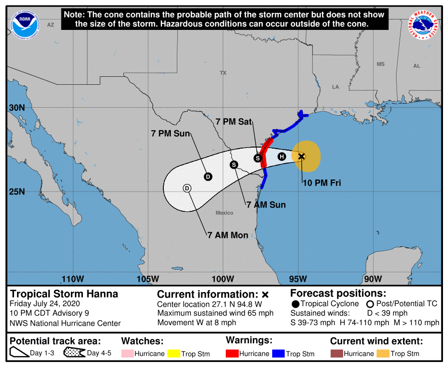
As of the 10:00 pm Friday night update from the National Hurricane Center, Tropical Storm Hanna was in a strengthening phase that may continue until she makes landfall around or just after midday on Saturday. Maximum sustained winds were at 65 MPH while she was moving to the west at 8 MPH. By the time you see this video, she may have already strengthened into a Category 1 Hurricane.
• A Hurricane Warning is up from Port Mansfield to Mesquite Bay, Texas.
• Tropical Storm Warnings are up from Mesquite Bay to High Island, Texas, and from Barra el Mezquital, Mexico, to Port Mansfield, Texas.
• A Storm Surge Warning is up from Baffin Bay to Sargent, Texas.
At this point, landfall for the center of Hanna looks to be just south of Corpus Christi near Baffin Bay. The forecast storm surge of 1-3 feet will occur south of the landfalling center while the surge will range from 1-5 feet north of the center.
Rainfall amounts over the next 3 days could reach as high as 6-10 inches in the orange areas, 4-6 inches in the yellow, and 1-3 inches in the shades of green. These heavy amounts could result in life-threatening flash flooding and isolated minor to moderate river flooding. After landfall, Hanna is expected to weaken rapidly and should dissipate over the rugged terrain of northern Mexico.
The Rest of the Tropics
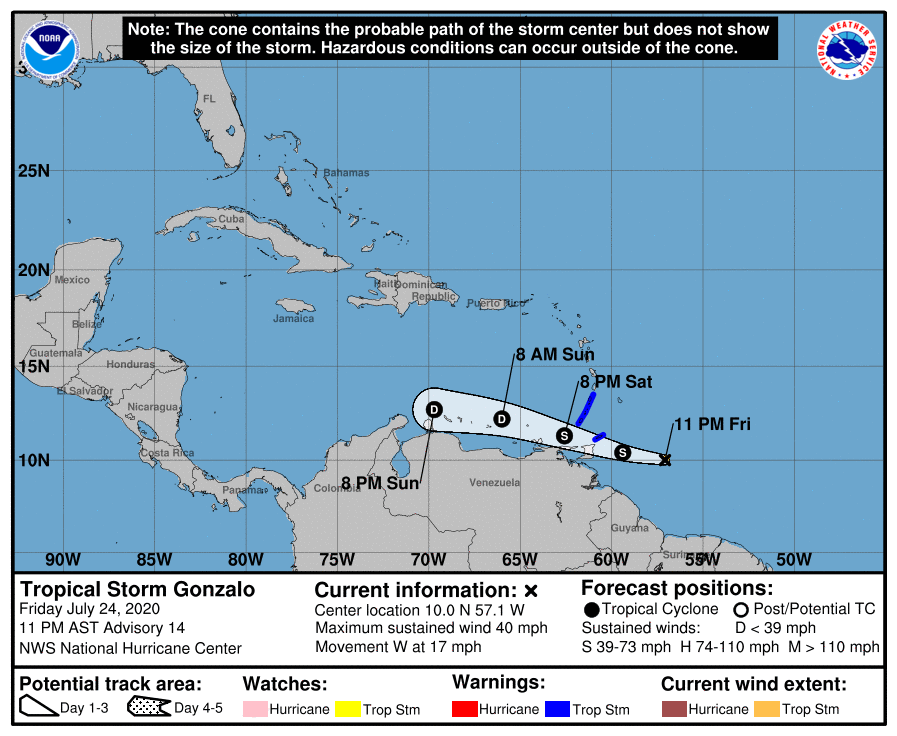
We can’t forget about Tropical Storm Gonzalo out there in the Atlantic as he continues to move westward at 17 MPH toward the southern Windward Island. As of the 10:00 pm Friday night update, maximum sustained winds have stabilized at 40 MPH after dropping in speed throughout the day. Dry air continues to be pulled into this small storm and it is possible that Gonzalo may weaken into a depression before impacting the Windward Islands. After that, Gonzalo is expected to dissipate within the next 2-3 days.
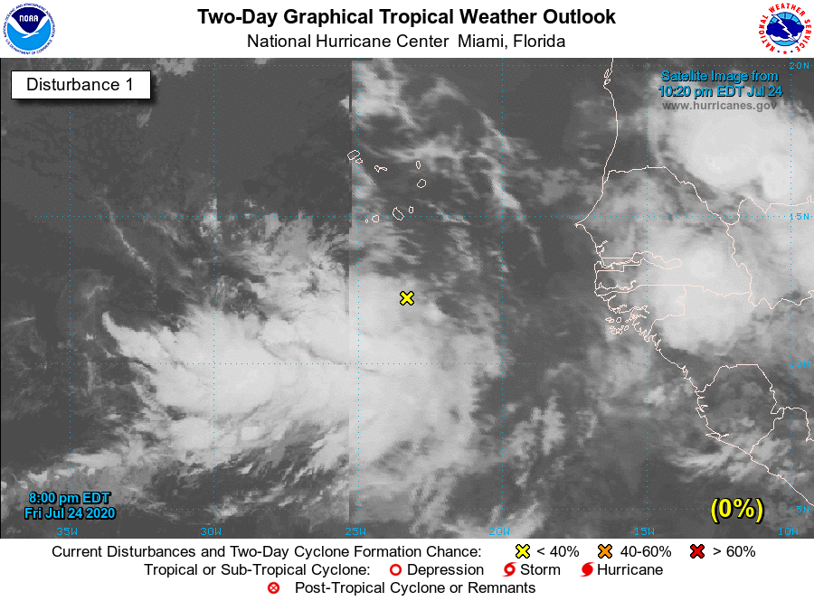
Last but not least, we have a tropical wave that has been designated as Invest 92L off of the coast of Africa and is a few hundred miles south of the Cabo Verde Islands. As it moves westward, steady organization and strengthening will occur over the next several days and could become a tropical depression early next week. It’s too early to know for sure where 92L will go, but if it becomes a tropical storm, it will be called Isaias.
On This Date in Weather History
1956 – The Andrea Doria sank in dense fog near Nantucket Lightship, MA. The ship was rammed by the Swedish-American liner, Stockholm, forty-five miles off the coast of Massachusetts. Fifty-two persons drowned or were killed by the impact.
Beach Forecast Center
Get the latest weather and rip current forecasts for the beaches from Bay St. Louis, MS, to Panama City Beach, FL, on our Beach Forecast Center page. There, you can select the forecast of the region that you are interested in.
Advertise On The Blog!
We had another fantastic year in 2019 with just over 17 million page views! That brings our total for the last 2 years close to 37 million page views! Don’t miss out! We can customize a creative, flexible, and affordable package that will suit your organization’s needs. Contact Bill Murray at (205) 687-0782.
E-Forecast
Get the Alabama Wx Weather Blog’s Seven-Day Forecast delivered directly to your inbox by email twice daily. It is the most detailed weather forecast available in Central Alabama. Subscribe here… It’s free!
Connect With The Blog On Social Media
You can find the AlabamaWx Weather Blog on the major social media networks:
Facebook
Twitter
Instagram
WeatherBrains
There are several ways to watch or listen to the podcast that is all about the weather. Watch live starting at 8:00 pm CT on Monday nights at live.bigbrainsmedia.com, James Spann’s Youtube Channel, or on one of ABC 3340’s digital weather channels (17.2, 40.2, 68.3). Listen to the recorded audio podcast at WeatherBrains.com or on your favorite podcast platform (Apple Podcasts, Stitcher, Spotify, etc.), or watch the recorded video on James Spann’s Youtube channel.
Category: Alabama's Weather, ALL POSTS, Tropical, Weather Xtreme Videos
About the Author (Author Profile)
Scott Martin is an operational meteorologist, professional graphic artist, musician, husband, and father. Not only is Scott a member of the National Weather Association, but he is also the Central Alabama Chapter of the NWA president. Scott is also the co-founder of Racecast Weather, which provides forecasts for many racing series across the USA. He also supplies forecasts for the BassMaster Elite Series events including the BassMaster Classic.Subscribe
If you enjoyed this article, subscribe to receive more just like it.


