

Sunday Weather Xtreme Video: Shower and Storm Chances Ramping Up; Watching Invest 92L
Hurricane Hanna just ran out of ocean before it became a category two storm yesterday afternoon. It made landfall around 5 p.m. just north of Port Mansfield, Texas, between Corpus Christi and Brownsville. There is widespread wind damage around Port Mansfield, including rolled mobile homes and numerous downed power poles. A 103 mph wind gust was observed at a National Ocean Service station at Rincon de San Jose, Texas. An 81 mph wind was observed at Baffin Bay. Up to a foot of rain has fallen overnight over parts of South Texas and the Rio Grande Valley. Storm surge reached 6.2 feet at Bob Hall Pier near Corpus Christi, Texas.
GONZALO: Tropical Storm Gonzalo dissipated over the southern Windward Islands at 5 p.m. yesterday, spelling the end of that system, which was the earliest G storm in Atlantic history.
OF COURSE: Hanna was also the earliest H storm in Atlantic Hurricane history, beating 2005’s Harvey.
JUST THE BEGINNING: Tropical Storm Hanna is moving across Northeast Mexico this morning, dumping more heavy rain. The system will dissipate over northern Mexico by Monday morning, but not before producing life-threatening flooding. A flash flood emergency is in effect in Hidalgo County, Texas, west of McAllen, including the town of Mission, where numerous water rescues are underway. 6.48 inches of rain soo far in McAllen through 5:58 a.m. this morning.
MEANWHILE, IN THE PACIFIC: Hurricane Douglas is brushing across the northern Hawaiian Islands this morning with top winds of 90 mph, dangerously high tides and waves, and heavy rainfall. Douglas should weaken to a tropical storm by Monday morning as it departs its Hawaiian Holiday.
UP NEXT: Invest 91L is our next problem in the Atlantic. It is a broad low-pressure system and tropical wave located over 2,000 miles east of the Lesser Antilles. The system is large and disorganized, so it will be slow to develop, but that is in its favor, unlike Gonzalo, that was small, and vulnerable. By Monday or Tuesday, the system is likely to develop into a tropical depression and then into a tropical storm. When it does, it will become Isaias. It is pronounced ees-ah-EE-ahs.
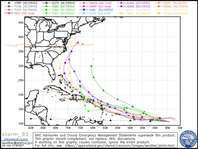
WHAT HAPPENS NEXT: There are really three main scenarios for this potential system. It may not develop at all, hampered by dry air. This doesn’t look very likely. It could remain weaker and stay on a more southerly track into the Caribbean where it will encounter the same hostile environment that Gonzalo ran into. That’s possible but seems unlikely. It could follow a path proposed by the EEuro and run into the Greater Antilles including Hispaniola and get the stuffing knocked out of it, meandering westward after that. The best possibility in my book is that the storm will move just off the northern Leeward Islands and the Bahamas, then toward the southeastern U.S. coast, perhaps northeastern Florida, Georgia, or the Carolinas the first week of August. This might allow it to harmlessly curve out to sea (yes, please). Lots of possibilities are on the table.
BACK TO ALABAMA’S WEATHER: Rainfall was fairly widespread across Central Alabama on Saturday. Amounts were generally around one quarter to one-half inch, with some one inch and two-inch amounts in spots. The storms were the result of a warm, moist, and unstable airmass across the state. Aided by the influence of the landfilling Hurricane Hanna, the sea breeze front made it all the way into the I-20 Corridor during the evening with more showers and storms. The leftover boundaries and increased moisture will lead to additional enhanced rain chances today.
FOR YOUR SUNDAY AND MONDAY: Scattered showers and storms will develop again today in the warm and humid airmass across the area. Highs will top out in the lower 90s.
REST OF THE WEEK: Moisture levels will slowly increase all week as tropical moisture increases over the state. In addition, there will be a frontal boundary just to our north, enhancing our rain chances, especially during the afternoon and evening hours. Those enhanced rain chances will be with us through the end of the week. Highs will be in the upper 80s. Lows will be in the lower 70s. One good thing is that the increased rain chances will keep our recent heat in check.
WEEKEND: The same trends will continue into the weekend, with higher than normal rain and thunderstorm chances each afternoon and evening, with highs in the upper 80s and lows in the lower 70s.
VOODOO TEERRIITORY: Toward the end of the forecast period, the passage of Isaias will probably allow drier air to push down into Alabama and the South on the backside of the circulation.
GULF COAST WEATHER: Mostly cloudy conditions with a good chance of showers and storms will be the norm through midweek along the beautiful beaches of Alabama and Northwest Florida. Sunshine should start returning by Thursday or so. The rip current risk should be moderate now that Hanna has gone inland. Water temperatures are in the lower 80s. Air temperatures will be in the middle and upper 80s each day, with lows in the upper 70s.
WEATHERBRAINS: One of the biggest weather-related risks during the summer months is the possibility of a child dying in a vehicle from heatstroke. We will be talking about the subject this week on WeatherBrains, the weekly netcast that’s all about the weather. Check out the show at www.WeatherBrains.com. You can also subscribe on iTunes. You can watch the show live at: http://live.bigbrainsmedia.com/ You will be able to see the show on the James Spann 24×7 weather channel on cable or directly over the air on the dot 2 feed.
ON THIS DATE IN 1952: Alabama was broiling in the middle of one of its worst five heat waves ever. July 1952 is the fifth hottest month in Birmingham history and featured nine days with highs above 100F. The hottest days at Birmingham were the 25th and 29th when the mercury peaked at 106F at Birmingham. On this date, firefighters were battling a huge forest fire that threatened to raze the town of Cropwell in St. Clair County. Other forest fires were raging across North and Central Alabama. Follow my weather history tweets on Twitter. I am @wxhistorian at Twitter.com.
Category: Alabama's Weather, ALL POSTS, Tropical
About the Author (Author Profile)
Bill Murray is the President of The Weather Factory. He is the site's official weather historian and a weekend forecaster. He also anchors the site's severe weather coverage. Bill Murray is the proud holder of National Weather Association Digital Seal #0001 @wxhistorianSubscribe
If you enjoyed this article, subscribe to receive more just like it.


