


A LOOK OUT THE WINDOW AT 12:40 PM
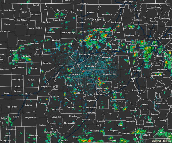
We have a good bit of scattered shower and thunderstorm activity across Central Alabama as we are moving through the latter half of the midday hour. The heaviest activity was occurring over the northern parts of Blount County and over into southern Marshall and northern Etowah counties. The good news is that none of these storms are strong and most will stay that way throughout the day.
As of the 12:00 pm Round-Up, temperatures across the area were in the 80s. The cool spot was Talladega at 81 degrees. The warm spots were Troy, Montgomery, and Birmingham all at 87 degrees.
FORECAST FOR THE REST OF YOUR TUESDAY
Skies will be mostly cloudy throughout the rest of the afternoon and into the early evening hours as scattered to numerous showers and thunderstorms will be likely. The good news is that temperatures will be held back to a more bearable mid to upper 80s across Central Alabama. For tonight and through the overnight hours, we’ll continue to have a chance of scattered showers and thunderstorms across the area. Lows will be in the lower to mid-70s.
A WET WEDNESDAY
Wednesday looks to be a wet day across Central Alabama as we’ll have widespread showers and thunderstorms across the area. While it may not rain all day long, rain will be likely at any time. Afternoon highs will be in the mid to upper 80s.
THE TROPICS
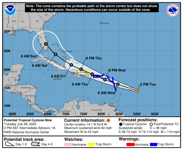
As of the 10:00 am update, Invest 92L has been designated as Potential Tropical Cyclone Nine. At this point, with sustained winds at 40 MPH, once it organizes enough to gain a central point of rotation, it will skip the depression stage and start off as Tropical Storm Isaias (ee sah ee as). Movement is currently to the west at 23 MPH. There will be a reduction in forward speed is expected over the next few days. On the forecast track, the system is forecast to move through the Leeward Islands on Wednesday, near or over the Virgin Islands and
Puerto Rico Wednesday night, and near or over Hispaniola on Thursday. Some strengthening is expected during the next 48 hours, and the system is forecast to become a tropical storm tonight or Wednesday.
At this point, it does look like parts of the United States will be affected by Isaias as we get into the weekend. For now, the cone has it moving into Florida on Sunday morning as a tropical storm. We’ll get a better picture after this becomes a tropical storm and the forecast track will be updated. This storm has the potential to move into the Gulf of Mexico, but nearly all of the models have it curving to the north and eventually northeast over Florida or just to the west of the Florida peninsula.


