

Occasional Showers Through Friday
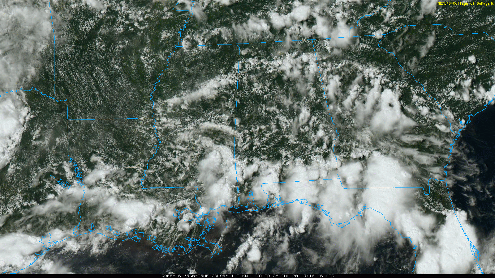
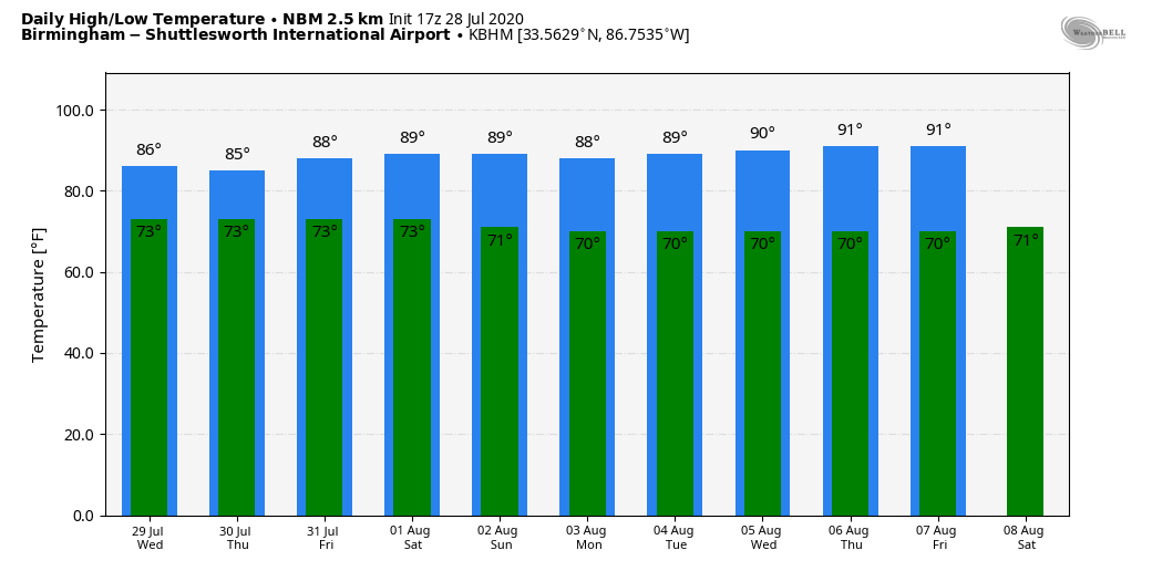
RADAR CHECK: Showers and thunderstorms continue to increase across the great state of Alabama this afternoon; they are slow movers and dropping heavy amounts of rain in spots. Otherwise, we have a mix of sun and clouds with temperatures mostly in the 80s. The average high for Birmingham on July 28 is 91.
We will maintain the chance of showers through the night tonight in the tropical air over Alabama.
REST OF THE WEEK: Look for scattered to numerous showers and thunderstorms each day through Friday; the sky will feature more clouds than sun, and highs will be in the 80s. While most of the rain will come from noon to midnight, we can’t rule out a few late night or morning showers as well. Rain amounts from now through Friday will be in the 1-2 inch range for most of the state.
THE ALABAMA WEEKEND: For now the weekend looks like it will feature some classic summer weather. A mix of sun and clouds Saturday and Sunday with random, scattered, mostly afternoon and evening showers and thunderstorms. Highs will be in the 88-91 degree range.
NEXT WEEK: We will keep the summer persistence forecast going through the week. Partly sunny days, a few storms during the afternoon and evening hours, and highs around 90 degrees. See the Weather Xtreme video for maps, graphics, and more details.
TROPICS: NHC has defined the well organized disturbance east of the Leeward/Windward Islands as “Potential Tropical Cyclone Nine”… it could be a tropical depression by the time you read this. Regardless of the exact track, the system is expected to bring locally heavy rainfall to much of the Lesser Antilles, and tropical-storm-force winds to portions of the Leeward Islands, the Virgin Islands, and Puerto Rico within the next 24-48 hours. After that time, a general west-northwestward heading should continue but as mentioned before, uncertainty exists as to how close the system tracks to Hispaniola, Cuba, the Bahamas, and Florida. It should be noted that a stronger cyclone is likely to favor a more northern track, while a weaker system is likely to remain more equatorward. The long-term average NHC track forecast errors at days 4 and 5 are 140 and 175 nautical miles, respectively.
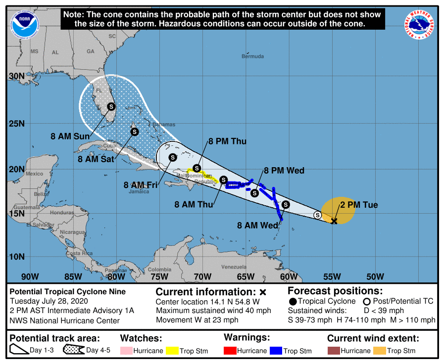
NHC keeps the system as a tropical depression through the weekend. Odds are high that this won’t be a Gulf of Mexico system, but that is certainly not carved in stone. Once we get a well defined center, and better upper air data from Hurricane Hunters, forecast confidence will improve. The name will be Isaias when it reaches tropical storm strength.
The rest of the Atlantic basin is quiet.
ON THIS DATE IN 1960: Tropical Storm Brenda developed in the northeastern Gulf of Mexico; it was the second named storm of the 1960 Atlantic hurricane season. After moving ashore over the Florida Peninsula, and accelerated northeast along the U.S. East Coast, ultimately peaking as a moderate storm with winds of 60 mph before crossing the Mid-Atlantic states and New England; it dissipated on July 31 over southern Canada. The storm inflicted moderate damage in Florida, the worst since Hurricane Easy of 1950, and dropped heavy rainfall as far north as New York City.
BEACH FORECAST: Click here to see the AlabamaWx Beach Forecast Center page.
WEATHER BRAINS: Don’t forget you can listen to our weekly 90 minute show anytime on your favorite podcast app. This is the show all about weather featuring many familiar voices, including our meteorologists here at ABC 33/40.
CONNECT: You can find me on all of the major social networks…
Facebook
Twitter
Instagram
Pinterest
Snapchat: spannwx
Look for the next Weather Xtreme video here by 7:00 a.m. tomorrow…
Category: Alabama's Weather, ALL POSTS, Weather Xtreme Videos
About the Author (Author Profile)
James Spann is one of the most recognized and trusted television meteorologists in the industry. He holds the AMS CCM designation and television seals from the AMS and NWA. He is a past winner of the Broadcast Meteorologist of the Year from both professional organizations.Subscribe
If you enjoyed this article, subscribe to receive more just like it.


