

Tropical Storm Conditions Nearing the Leeward Islands; PTC-9 Not a Tropical Storm Yet
SUMMARY OF 1100 PM AST…0300 UTC…INFORMATION
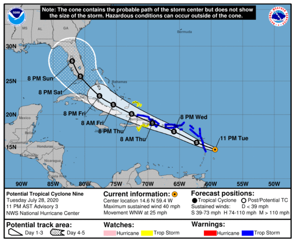
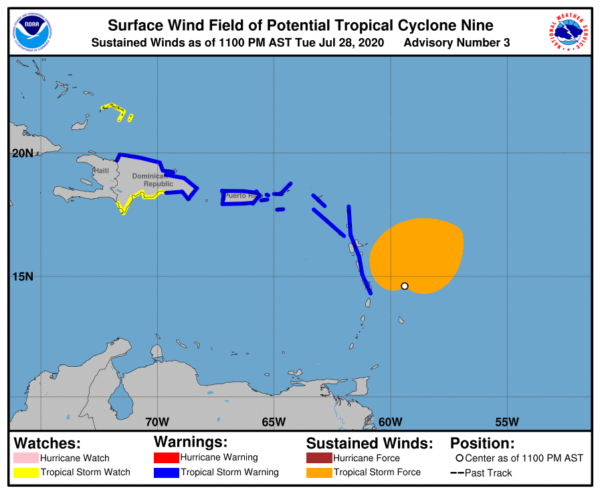
LOCATION…14.6N 59.4W
ABOUT 235 MI…380 KM SE OF THE LEEWARD ISLANDS
ABOUT 515 MI…830 KM ESE OF SAN JUAN PUERTO RICO
MAXIMUM SUSTAINED WINDS…40 MPH…65 KM/H
PRESENT MOVEMENT…WNW OR 295 DEGREES AT 25 MPH…41 KM/H
MINIMUM CENTRAL PRESSURE…1007 MB…29.74 INCHES
WATCHES AND WARNINGS
A Tropical Storm Warning is in effect for…
* Puerto Rico, Vieques, Culebra
* U.S. Virgin Islands
* British Virgin Islands
* Antigua, Barbuda, Montserrat, St. Kitts, Nevis, and Anguilla
* Guadeloupe, Martinique, St. Martin, and St. Barthelemy
* Saba and St. Eustatius
* St. Maarten
* Dominica
* The Dominican Republic from Punta Caucedo eastward to Cabo Engano and then westward along the northern coast to the Dominican Republic/Haiti border
A Tropical Storm Watch is in effect for…
* The Dominican Republic from the southern Haiti border eastward to Punta Caucedo
* The Turks and Caicos Islands
DISCUSSION AND OUTLOOK
At 1100 PM AST (0300 UTC), the disturbance was centered near latitude 14.6 North, longitude 59.4 West. The system is moving toward the west-northwest near 25 mph (41 km/h), and this general motion with some slight reduction in forward speed is expected over the next few days. On the forecast track, the system will move through the Leeward Islands on Wednesday, near or over the Virgin Islands and Puerto Rico Wednesday night, and near or over Hispaniola on Thursday.
Maximum sustained winds are near 40 mph (65 km/h) with higher gusts. Some strengthening is expected during the next 48 hours, and the system is forecast to become a tropical storm on Wednesday.
Environmental conditions are expected to be conducive for additional development, and a tropical storm is forecast to form on Wednesday.
* Formation chance through 48 hours…high…90 percent
* Formation chance through 5 days…high…90 percent
Tropical-storm-force winds extend outward up to 230 miles (370 km) from the center.
The estimated minimum central pressure is 1007 MB (29.74 inches).
HAZARDS AFFECTING LAND
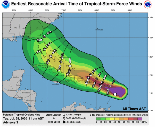
WIND: Tropical storm conditions are expected to reach the Leeward Islands late tonight or Wednesday morning, and spread across the U.S. and British Virgin Islands and Puerto Rico Wednesday afternoon through Thursday morning. These conditions are forecast to reach portions of the Dominican Republic within the warning area early Thursday. Tropical storm conditions are possible in the watch areas on Thursday.
RAINFALL: The potential tropical cyclone is expected to produce the following rain accumulations:
Across the northern Leeward Islands, British and U.S. Virgin Islands: 3 to 6 inches.
Across Puerto Rico: 3 to 6 inches, with isolated maximum totals of 10 inches.
Across the Dominican Republic: 3 to 6 inches, with isolated maximum totals of 8 inches.
These rainfall amounts could lead to life-threatening flash flooding and mudslides, as well as potential riverine flooding.
Rainfall is also expected in the following locations:
Across the Windward Islands: 1 to 3 inches.
Category: ALL POSTS, Severe Weather, Tropical
About the Author (Author Profile)
Scott Martin is an operational meteorologist, professional graphic artist, musician, husband, and father. Not only is Scott a member of the National Weather Association, but he is also the Central Alabama Chapter of the NWA president. Scott is also the co-founder of Racecast Weather, which provides forecasts for many racing series across the USA. He also supplies forecasts for the BassMaster Elite Series events including the BassMaster Classic.Subscribe
If you enjoyed this article, subscribe to receive more just like it.


