

Wet At Times Through Friday; Eyes On The Tropics
WET SUMMER PATTERN: We are forecasting occasional showers and thunderstorms across much of Alabama through Friday as a tropical airmass remains in place, along with a weak upper trough over the region. While most of the rain will come from noon to midnight, there will be some late night and morning activity as well. In fact, rain is falling on parts of Central Alabama early this morning. Showers will be efficient rain producers in this kind of airmass; some communities saw over two inches of rain yesterday.
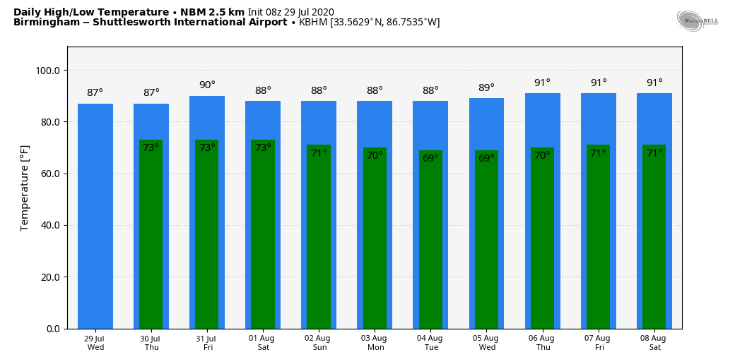
Temperatures will be below average because of clouds and showers; the high today and tomorrow will be only in the 83-86 degrees range, and in the upper 80s Friday.
THE ALABAMA WEEKEND: Showers become more scattered in nature over the weekend; chance of any one spot getting wet Saturday and Sunday will be in the 30/40 percent range. Otherwise, we are forecasting a mixture of sun and clouds both days with afternoon highs between 87 and 90 degrees.
NEXT WEEK: We are looking at pretty typical summer weather for much of the week. Partly sunny, hot, humid days with random, scattered, mostly afternoon and evening showers and thunderstorms. Highs at or just over 90 degrees… See the Weather Xtreme video for maps, graphics, and more details.
TROPICS: “Potential Tropical Cyclone Nine” should become Tropical Storm Isaias later today in the Atlantic. The system is moving through the southern Leeward Islands this morning. From there, it will move near or over the Virgin Islands and Puerto Rico tonight, near or over Hispaniola tomorrow, and near or over the southeastern Bahamas on Friday.
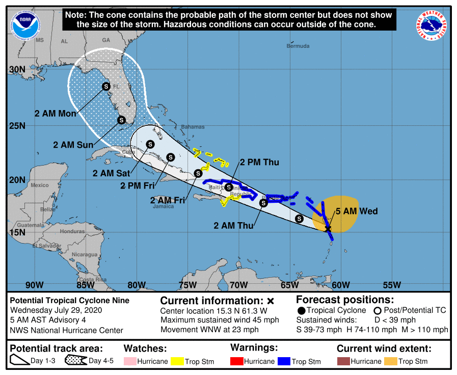
The latest forecast track moves the system through the Florida Peninsula (not the Panhandle) Sunday, but it should be emphasized that this forecast track is highly uncertain until a true circulation center forms (which should happen within the next 24 hours).
Concerning the intensity forecast, with the circulation expected to cross Hispaniola, weakening is likely due to interaction with land. The system will probably take some time to recover after moving over the very high mountains of Hispaniola, and some of the guidance after that time shows an increase in southwesterly shear over the Straits of Florida that could limit the potential of the cyclone. Simply put, there are a lot of hurdles in the system’s way, and NHC keeps the system below hurricane strength over the next five days.
It continues to look like Alabama and the Central Gulf Coast (Gulf Shores, Pensacola, Panama City Beach) will be on the dry, west side of the circulation. But again, we stress it is very early and confidence in the forecast track is low in the 3-5 day period. We will keep an eye on it.
The rest of the Atlantic basin is quiet.
TUESDAY’S RAIN: Some rain totals across Alabama yesterday included
Warrior/Corner 4.79″
Jacksonville 1.80″
Remlap 1.54″
ON THIS DATE IN 1960: Severe thunderstorms brought damaging winds, possibly as high as 100 mph to central Oklahoma. Eight planes and several hangars were damaged at Wiley Post Airfield, while two aircraft and additional hangars were damaged at Will Rogers World Airport. The winds caused seven injuries in the area, including two youths who were injured by flying debris.
BEACH FORECAST: Click here to see the AlabamaWx Beach Forecast Center page.
WEATHER BRAINS: Don’t forget you can listen to our weekly 90 minute show anytime on your favorite podcast app. This is the show all about weather featuring many familiar voices, including our meteorologists here at ABC 33/40.
CONNECT: You can find me on all of the major social networks…
Facebook
Twitter
Instagram
Pinterest
Snapchat: spannwx
Look for the next Weather Xtreme video here by 4:00 this afternoon… enjoy the day!
Category: Alabama's Weather, ALL POSTS, Weather Xtreme Videos
About the Author (Author Profile)
James Spann is one of the most recognized and trusted television meteorologists in the industry. He holds the AMS CCM designation and television seals from the AMS and NWA. He is a past winner of the Broadcast Meteorologist of the Year from both professional organizations.Subscribe
If you enjoyed this article, subscribe to receive more just like it.


