

A Little Cooler with Showers at Midday; PTC-9 Getting Better Organized an Will Soon Be Isaias
LOOKING OUT THE WINDOW AT 11:20 AM
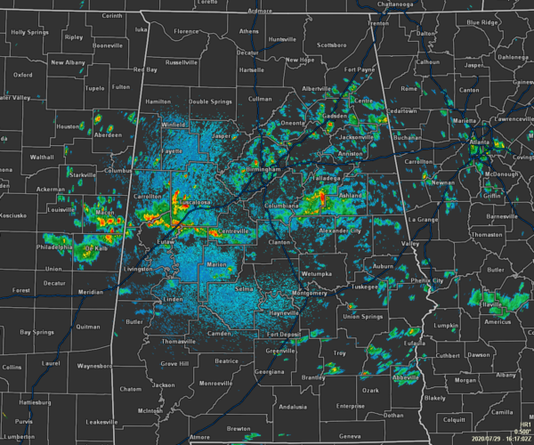
We have a decent bit of scattered showers across mainly the central and southern parts of Central Alabama as we are making our way toward the midday hour. At this point, there are no lightning strikes appearing on radar, but that will likely change as we get into the afternoon hours. Nearly all of North Alabama remains dry with the exception of the southern half of Dekalb County.
Temperatures across Central Alabama as of the 11:00 am Round-Up were in the mid-70s to the lower 80s as rain and cloud cover are keeping the readings lower than what we normally see during the summertime. Birmingham was at 78 degrees. Auburn, the Shelby County Airport, and Sylacauga were tied at 75 degrees as the cool spots. Anniston, Montgomery, and Troy were tied as the warm spots at 82 degrees.
WEATHER FOR THE REST OF YOUR WEDNESDAY
We’ll continue to have mostly cloudy skies throughout the rest of the daylight hours as showers and a few thunderstorms will be likely. While I do not believe severe weather will be an issue today, one or two storms may briefly become strong with gusty winds. Afternoon highs look to top out in the mid-80s for most with a few locations briefly hitting the upper 80s. Activity will decrease as we move into the evening and overnight hours, but we’ll keep a chance of scattered showers and maybe a clap of thunder in the forecast. Lows will bottom out in the lower to mid-70s.
A FEW STRONGER STORMS POSSIBLE FOR PARTS OF THE AREA ON THURSDAY
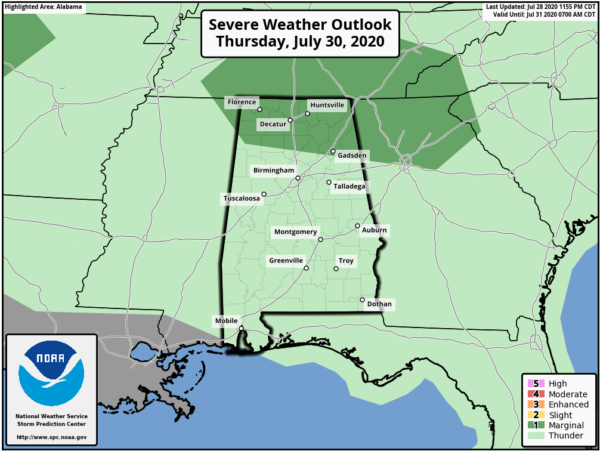
We’ll have an impulse move through the northern portions of Central Alabama and up into North Alabama during the morning on Thursday. With an increase in lift, increased lapse rates, and higher bulk shear, a few severe thunderstorms will be possible. Locations along and north of a line from Hamilton (Marion Co.) to Dodge City (Cullman Co.) to Oak Level (Cleburne Co.). It looks like at this point that damaging winds up to 60 MPH and hail up to quarter size in diameter will be the main threats. The threat should come to an end by 3:00 pm and shower and thunderstorm activity will be decreasing after that.
For the rest of Central Alabama… scattered to numerous showers and thunderstorms will be likely through the morning hours but coverage will begin to shrink during the afternoon hours. While a strong storm or two will be possible, severe weather is not expected. Afternoon highs across Central Alabama will be in the mid-80s to the lower 90s from northeast to southwest.
THE TROPICS
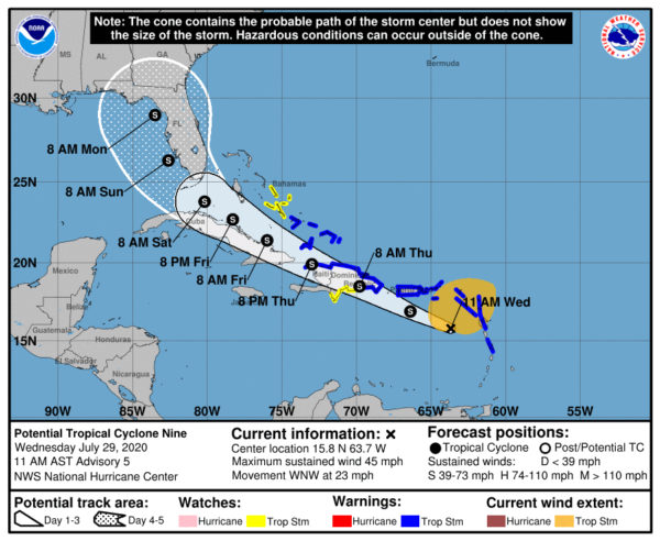
Surface observations from the Lesser Antilles show that the broader circulation of PTC-9 has become slightly better defined but a recent Air Force Reserve reconnaissance aircraft was still unable to find a well-defined circulation. Therefore, the system has not yet become a tropical storm.
The system continues moving briskly west-northwestward at 20 kt. The forecast reasoning remains unchanged as a ridge to the north of the system is expected to steer the disturbance west-northwestward during the next couple of days. This motion should bring the system near or over Hispaniola on Thursday and near eastern Cuba Thursday night and Friday. The ridge is forecast to weaken by the weekend which should cause a reduction in forward speed.
It still must be stressed that since the system lacks a well-defined center and remains in its formative stage, uncertainty in the specifics of the track forecast remain high in both the short and longer range. The latest NHC track forecast has been nudged slightly south of the previous advisory.
PTC-9 is still expected to become a tropical storm later today or tonight. Some additional intensification is then possible before the system reaches Hispaniola on Thursday, but weakening is likely to occur while it interacts with land. After that time, the system’s close proximity to eastern Cuba and an expected increase in southwesterly shear are likely to inhibit significant re-strengthening.
At this point, the forecast track will keep the Alabama Gulf Coast to the west of where the center is forecast to move onshore in Florida, but remember that the forecast track can and will change as PTC-9 becomes better organized and finally becomes Tropical Storm Isaias. Any shift in the forecast track to the west will put the Alabama Gulf Coast in a higher threat to receive impacts from the system. We’ll keep you updated.
Category: Alabama's Weather, ALL POSTS, Severe Weather, Tropical
About the Author (Author Profile)
Scott Martin is an operational meteorologist, professional graphic artist, musician, husband, and father. Not only is Scott a member of the National Weather Association, but he is also the Central Alabama Chapter of the NWA president. Scott is also the co-founder of Racecast Weather, which provides forecasts for many racing series across the USA. He also supplies forecasts for the BassMaster Elite Series events including the BassMaster Classic.Subscribe
If you enjoyed this article, subscribe to receive more just like it.


