

No Major Changes As of 1:00 pm Update on PTC-9
SUMMARY OF 200 PM AST…1800 UTC…INFORMATION
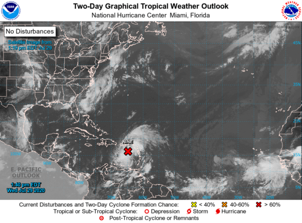
LOCATION…16.2N 64.7W
ABOUT 105 MI…165 KM S OF ST. CROIX
ABOUT 180 MI…285 KM SSE OF SAN JUAN PUERTO RICO
MAXIMUM SUSTAINED WINDS…45 MPH…75 KM/H
PRESENT MOVEMENT…WNW OR 290 DEGREES AT 23 MPH…37 KM/H
MINIMUM CENTRAL PRESSURE…1006 MB…29.71 INCHES
WATCHES AND WARNINGS
A Tropical Storm Warning is in effect for…
* Puerto Rico, Vieques, Culebra
* U.S. Virgin Islands
* The British Virgin Islands
* Montserrat, St. Kitts, Nevis, and Anguilla
* St. Martin, and St. Barthelemy
* Saba and St. Eustatius
* St. Maarten
* The Dominican Republic entire southern and northern coastlines
* North coast of Haiti from Le Mole St Nicholas eastward to the northern border with the Dominican Republic
* the Turks and Caicos Islands
* Southeastern Bahamas including the Acklins, Crooked Island, Long Cay, the Inaguas, Mayaguana, and the Ragged Islands
A Tropical Storm Watch is in effect for…
* Central Bahamas, including Cat Island, the Exumas, Long Island, Rum Cay, and San Salvador
DISCUSSION AND OUTLOOK
At 200 PM AST (1800 UTC), the disturbance was centered near latitude 16.2 North, longitude 64.7 West. The system is moving toward the west-northwest near 23 mph (37 km/h), and this general motion with a reduction in forward speed is expected over the next few days. On the forecast track, the system will move near or just south of Puerto Rico later today and tonight, near or over Hispaniola on Thursday, and near or over eastern Cuba on Friday.
Maximum sustained winds are near 45 mph (75 km/h) with higher gusts. Some increase in strength is forecast through tonight, with weakening likely on Thursday due to land interaction. Some restrengthening is possible this weekend. A wind gust of 44 mph (71 km/h) was recently reported at the Luis Munoz Marin International Airport in San Juan. A wind gust of 44 mph (71 km/h) was also reported at St. Thomas in the U.S. Virgin Islands within the past few hours. In St. Maarten, a wind gust to 51 mph (81 km/h) was observed late this morning.
Environmental conditions are expected to be conducive for additional development, and a tropical storm is forecast to form later today or tonight.
* Formation chance through 48 hours…high …90 percent
* Formation chance through 5 days…high…90 percent
Tropical-storm-force winds extend outward up to 275 miles (445 km) primarily to the north and northeast of the center.
The estimated minimum central pressure is 1006 MB (29.71 inches).
HAZARDS AFFECTING LAND
WIND: Tropical storm conditions are moving across portions of the Leeward Islands and will spread across the U.S. and the British Virgin Islands and Puerto Rico this afternoon through Thursday morning. These conditions are forecast to reach portions of the Dominican Republic and Haiti within the warning area early Thursday, and the southeastern Bahamas and Turks and Caicos Thursday afternoon. Tropical storm conditions are possible in the watch areas on Thursday and Friday.
RAINFALL: The disturbance is expected to produce the following rain accumulations:
Across the northern Leeward Islands, British and U.S. Virgin Islands: 3 to 6 inches.
Across Puerto Rico: 3 to 6 inches, with isolated maximum totals of 10 inches.
Across the Dominican Republic, northern Haiti, and Turks and Caicos: 3 to 6 inches, with isolated maximum totals of 8 inches.
Across the Inagua Islands: 4 to 8 inches, with isolated totals of 12 inches.
These rainfall amounts may lead to life-threatening flash flooding and mudslides, as well as potential riverine flooding beginning today. Urban and small stream flooding is expected for the U.S. Virgin Islands and eastern Puerto Rico.
SURF: Swells generated by Potential Tropical Cyclone Nine will be affecting portions of the Leeward Islands, the Virgin Islands, and Puerto Rico during the next day or two. These swells are forecast to reach the north coast of the Dominican Republic, the Turks and Caicos Islands, and the southeastern Bahamas tonight or Thursday. These swells are likely to cause life-threatening surf and rip current conditions. Please consult products from your local weather office.
Category: ALL POSTS, Severe Weather, Tropical
About the Author (Author Profile)
Scott Martin is an operational meteorologist, professional graphic artist, musician, husband, and father. Not only is Scott a member of the National Weather Association, but he is also the Central Alabama Chapter of the NWA president. Scott is also the co-founder of Racecast Weather, which provides forecasts for many racing series across the USA. He also supplies forecasts for the BassMaster Elite Series events including the BassMaster Classic.Subscribe
If you enjoyed this article, subscribe to receive more just like it.


