

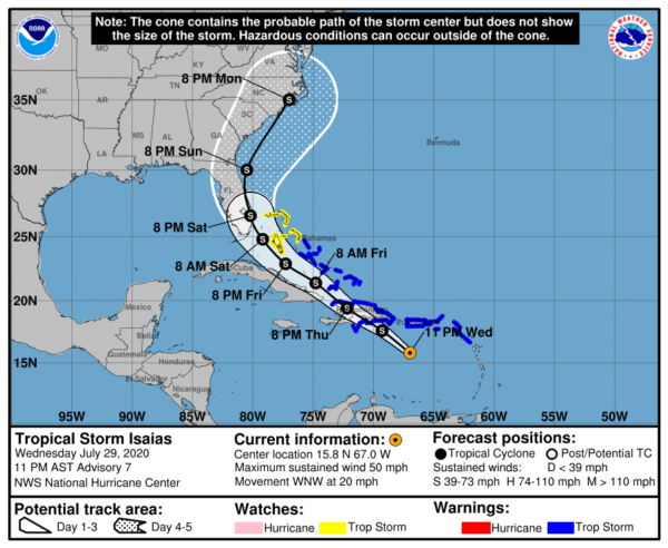
At 10:00 pm, Tropical Storm Isaias Has Formed; Track Shifts East to the Southeastern US Atlantic Coast
SUMMARY OF 1100 PM AST…0300 UTC…INFORMATION
LOCATION…15.8N 67.0W
ABOUT 155 MI…250 KM S OF PONCE PUERTO RICO
ABOUT 265 MI…430 KM SE OF SANTO DOMINGO DOMINICAN REPUBLIC
MAXIMUM SUSTAINED WINDS…50 MPH…85 KM/H
PRESENT MOVEMENT…WNW OR 285 DEGREES AT 20 MPH…31 KM/H
MINIMUM CENTRAL PRESSURE…1004 MB…29.65 INCHES
WATCHES AND WARNINGS
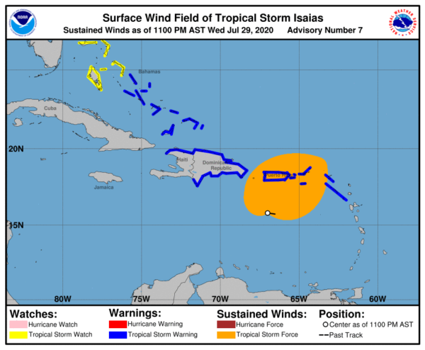
A Tropical Storm Warning is in effect for…
* Puerto Rico, Vieques, Culebra
* U.S. Virgin Islands
* The British Virgin Islands
* St. Martin and St. Barthelemy
* Saba and St. Eustatius
* St. Maarten
* Dominican Republic entire southern and northern coastlines
* North coast of Haiti from Le Mole St Nicholas eastward to the northern border with the Dominican Republic
* The Turks and Caicos Islands
* Southeastern Bahamas including the Acklins, Crooked Island, Long Cay, the Inaguas, Mayaguana, and the Ragged Islands
* Central Bahamas, including Cat Island, the Exumas, Long Island, Rum Cay, and San Salvador
A Tropical Storm Watch is in effect for…
* Northwestern Bahamas including Andros Island, New Providence, Eleuthera, Abacos Islands, Berry Islands, Grand Bahamas Island, and Bimini
Interests in Cuba and the Florida peninsula should monitor the progress of this system.
DISCUSSION AND OUTLOOK
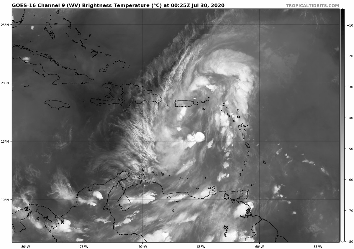
At 1100 PM AST (0300 UTC), the center of Tropical Storm Isaias was located near latitude 15.8 North, longitude 67.0 West. Isaias is moving toward the west-northwest near 20 mph (31 km/h), and a west-northwestward to northwestward motion with some decrease in forward speed is expected over the next couple of days. On the forecast track, the center of Isaias will move over Hispaniola on Thursday and near the southeastern Bahamas by early Friday.
Maximum sustained winds are near 50 mph (85 km/h) with higher gusts. Some weakening is likely when the center moves over Hispaniola with some strengthening expected by Friday.
Tropical-storm-force winds extend outward up to 345 miles (555 km) mainly to the northeast of the center.
The estimated minimum central pressure is 1004 MB (29.65 inches).
HAZARDS AFFECTING LAND
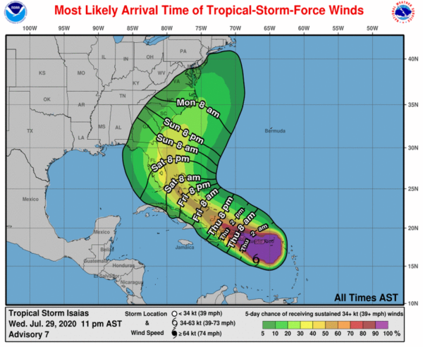
WIND: Tropical storm conditions will continue across portions of the Leeward Islands, the U.S. and British Virgin Islands, and Puerto Rico through tonight. These conditions are forecast to reach portions of the Dominican Republic and Haiti within the warning area by late tonight or early Thursday, and the southeastern Bahamas and Turks and Caicos Thursday afternoon. Tropical storm conditions are expected in the Central Bahamas beginning Friday morning and are possible in the northwestern Bahamas beginning late Friday.
RAINFALL: Isaias is expected to produce the following rain accumulations:
Across the British and U.S. Virgin Islands and Turks and Caicos: 3 to 6 inches.
Across Puerto Rico, the Dominican Republic, northern Haiti, and eastern Cuba: 3 to 6 inches, with isolated maximum totals of 8 inches.
Across the southeastern Bahamas: 4 to 8 inches.
These rainfall amounts may lead to life-threatening flash flooding and mudslides, as well as potential riverine flooding beginning today. Urban and small stream flooding is expected for the U.S. Virgin Islands, eastern Puerto Rico, and Hispaniola.
SURF: Swells generated by Isaias will be affecting portions of the Leeward Islands, the Virgin Islands, and Puerto Rico through Thursday. These swells are forecast to reach the north coast of the Dominican Republic, the Turks and Caicos Islands, and the southeastern Bahamas tonight or Thursday. These swells are likely to cause life-threatening surf and rip current conditions. Please consult products from your local weather office.
Category: ALL POSTS, Severe Weather, Tropical
About the Author (Author Profile)
Scott Martin is an operational meteorologist, professional graphic artist, musician, husband, and father. Not only is Scott a member of the National Weather Association, but he is also the Central Alabama Chapter of the NWA president. Scott is also the co-founder of Racecast Weather, which provides forecasts for many racing series across the USA. He also supplies forecasts for the BassMaster Elite Series events including the BassMaster Classic.Subscribe
If you enjoyed this article, subscribe to receive more just like it.


