

More Tropical Showers For Alabama
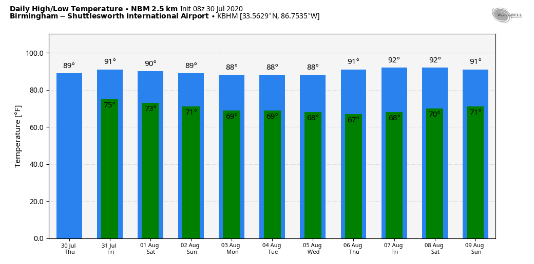
SOUPY AIRMASS STAYS IN PLACE: A moisture laden airmass will stay in place across Alabama today with high humidity levels. A few showers have already developed early this morning, and we expect scattered to numerous showers and thunderstorms this afternoon and tonight. A few spots could see heavy amounts of rain, but organized severe thunderstorms are not expected. Highs will remain in the 80s today due to clouds and rain.
TOMORROW THROUGH THE WEEKEND: Not much change; a few passing showers and storms are a good possibility each day, although they could be a little less numerous Sunday. Most of the showers will come from noon to midnight, but in this kind of environment you can’t rule out some rain during the late night or morning hours. Highs will be in the mid to upper 80s tomorrow and Saturday, and close to 90 Sunday.
NEXT WEEK: For now the weather look pretty routine for August with partly sunny, hot, humid days and the daily round of random, scattered, mostly afternoon and evening showers and thunderstorms. Highs will be pretty close to 90 degrees each day… See the Weather Xtreme video for maps, graphics, and more details.
TROPICS: Tropical Storm Isaias is southwest of Puerto Rico this morning with sustained winds of 60 mph. The latest forecast track from NHC takes it close to the Atlantic coast of Florida over the weekend, then curving northeast toward the Outer Banks of North Carolina by Monday night.
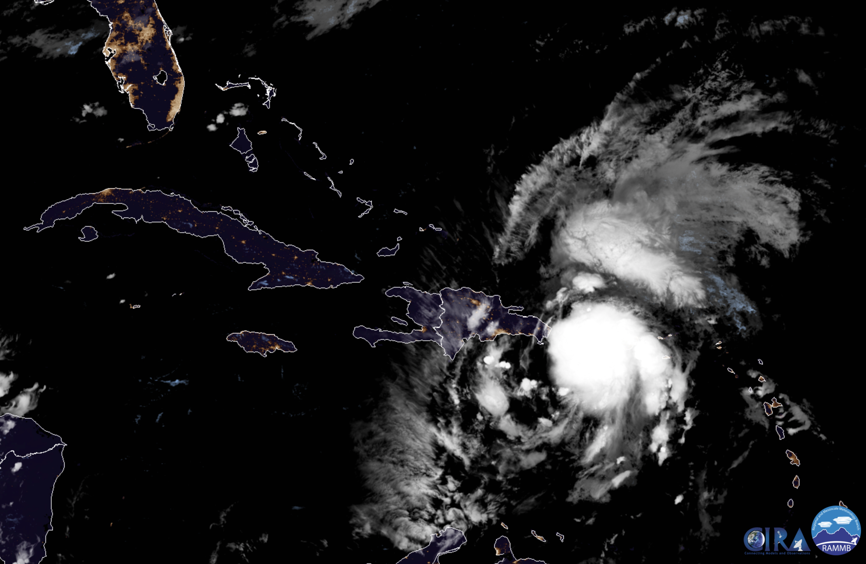
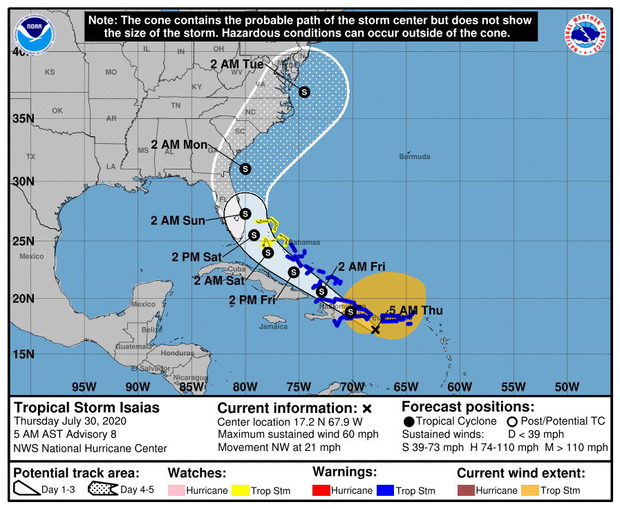
The intensity forecast is quite tricky. In the short term, Isaias is expected to move across Hispaniola, as the storm’s interaction with the mountainous island should cause some weakening and disruption to the circulation. Models suggest that a new center could form, and the environmental conditions would support gradual intensification. The intensity models have been trending higher, and the official forecast is nudged upward accordingly, now showing a peak intensity of 70 mph when the storm is near the coast of Florida and the Southeast U.S. Coast. It should be noted that there are models that show hurricane strength near the U.S. but, given the large amount of uncertainty, it is preferred to stay on the conservative side for now. We should have a better idea of how strong Isaias will become near the U.S. after reconnaissance aircraft sample the storm and after it passes Hispaniola later today.
Isaias will not impact Alabama or the Central Gulf Coast (Gulf Shores, Pensacola, Destin, Panama City Beach). It has potential to bring periods of heavy rain and gusty winds to the Florida Peninsula, especially cities on the Atlantic coast, over the weekend.
The rest of the Atlantic basin is quiet.
ON THIS DATE IN 1970: Hurricane Celia was born in the northwest of the Caribbean Sea on this day. The hurricane would be one of the worst ever to hit Texas and would reach Texas late on August 3. The storm reached its peak as it made landfall near Corpus Christi, Texas, as a strong Category 3 hurricane. Hurricane Celia is currently the last major hurricane to make landfall on the middle Texas Coast until Hurricane Harvey in 2017.
BEACH FORECAST: Click here to see the AlabamaWx Beach Forecast Center page.
WEATHER BRAINS: Don’t forget you can listen to our weekly 90 minute show anytime on your favorite podcast app. This is the show all about weather featuring many familiar voices, including our meteorologists here at ABC 33/40.
CONNECT: You can find me on all of the major social networks…
Facebook
Twitter
Instagram
Pinterest
Snapchat: spannwx
Look for the next Weather Xtreme video here by 4:00 this afternoon… enjoy the day!
Category: Alabama's Weather, ALL POSTS, Weather Xtreme Videos
About the Author (Author Profile)
James Spann is one of the most recognized and trusted television meteorologists in the industry. He holds the AMS CCM designation and television seals from the AMS and NWA. He is a past winner of the Broadcast Meteorologist of the Year from both professional organizations.Subscribe
If you enjoyed this article, subscribe to receive more just like it.


