

Isaias Now Forecast to Become A Hurricane on Friday or Friday Night
SUMMARY OF 4:00 PM CDT…2100 UTC…INFORMATION
LOCATION…19.5N 70.6W
ABOUT 155 MI…250 KM WNW OF PUNTA CANA DOMINICAN REPUBLIC
ABOUT 250 MI…400 KM SE OF THE SOUTHEASTERN BAHAMAS
MAXIMUM SUSTAINED WINDS…60 MPH…95 KM/H
PRESENT MOVEMENT…NW OR 310 DEGREES AT 20 MPH…31 KM/H
MINIMUM CENTRAL PRESSURE…999 MB…29.50 INCHES
WATCHES AND WARNINGS
A Tropical Storm Warning is in effect for…
* Dominican Republic entire southern and northern coastlines
* North coast of Haiti from Le Mole St Nicholas eastward to the northern border with the Dominican Republic
* Turks and Caicos Islands
* Southeastern Bahamas including the Acklins, Crooked Island, Long Cay, the Inaguas, Mayaguana, and the Ragged Islands
* Central Bahamas, including Cat Island, the Exumas, Long Island, Rum Cay, and San Salvador
* Northwestern Bahamas including Andros Island, New Providence, Eleuthera, Abacos Islands, Berry Islands, Grand Bahamas Island, and Bimini
A Tropical Storm Watch is in effect for…
* East coast of Florida from Ocean Reef to Sebastian Inlet
The Tropical Storm Warnings for the central and northwest Bahamas may be upgraded to Hurricane Warnings this evening or tonight.
Interests elsewhere along the southeast coast of the United States should monitor the progress of this system. Additional watches or warnings may be required for a portion of the Florida peninsula tonight or Friday.
DISCUSSION AND OUTLOOK
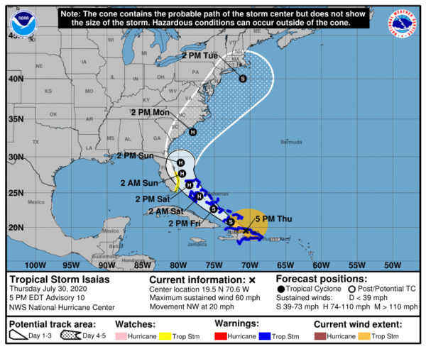
At 500 PM EDT (2100 UTC), the center of Tropical Storm Isaias was located near latitude 19.5 North, longitude 70.6 West. Isaias is moving toward the northwest near 20 mph (31 km/h) and a northwestward motion with some decrease in forward speed is expected over the next couple of days. On the forecast track, the center of Isaias will move near the Southeastern Bahamas by late tonight. Isaias is forecast to be near the Central Bahamas Friday night and move near or over the Northwest Bahamas and near South Florida on Saturday.
Maximum sustained winds are near 60 mph (95 km/h) with higher gusts. Strengthening is forecast during the next day or so, and Isaias is forecast to become a hurricane on Friday or Friday night.
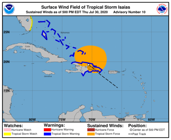
Tropical-storm-force winds extend outward up to 240 miles (390 km)from the center.
The estimated minimum central pressure based on surface observations in the Dominican Republic is 999 MB (29.50 inches).
HAZARDS AFFECTING LAND
STORM SURGE: A dangerous storm surge will raise water levels by as much as 3 to 5 feet above normal tide levels in areas of onshore flow in the central and northwest Bahamas. Storm surge will raise water level by as much as 1 to 3 ft above normal tide levels in the southeastern Bahamas.
WIND: Tropical storm conditions will continue to spread across portions of the Dominican Republic, Haiti, the southeastern Bahamas and Turks and Caicos within the warning area tonight. Tropical storm conditions are expected to begin in the central Bahamas Friday morning and spread into the northwestern Bahamas beginning late Friday. Hurricane conditions are expected within portions of the central and northwestern Bahamas Friday night and Saturday.
Tropical storm conditions are possible in the watch area in Florida beginning Saturday.
RAINFALL: Isaias is expected to produce the following rain accumulations:
Puerto Rico, Dominican Republic and northern Haiti: 4 to 8 inches, with isolated maximum totals of 12 inches.
Bahamas, Turks and Caicos: 4 to 8 inches.
Cuba: 1 to 2 inches, with isolated maximum totals of 4 inches.
These rainfall amounts will lead to life-threatening flash flooding and mudslides, as well as river flooding. Urban and small stream flooding is expected for the U.S. Virgin Islands, eastern and southwestern Puerto Rico, and Hispaniola.
Heavy rains associated with Isaias may begin to affect eastern Florida over the weekend. This rain could result in isolated flash and urban flooding, especially in low-lying and poorly drained areas.
SURF: Swells generated by Isaias are affecting portions of the Leeward Islands, the Virgin Islands, Puerto Rico, the Dominican Republic, the Turks and Caicos Islands and the southeastern Bahamas. These swells will spread along the coast of Cuba and into the central and northwestern Bahamas over the next day or two. These swells are likely to cause life-threatening surf and rip current conditions. Please consult products from your local weather office.
Category: ALL POSTS, Severe Weather, Tropical
About the Author (Author Profile)
Scott Martin is an operational meteorologist, professional graphic artist, musician, husband, and father. Not only is Scott a member of the National Weather Association, but he is also the Central Alabama Chapter of the NWA president. Scott is also the co-founder of Racecast Weather, which provides forecasts for many racing series across the USA. He also supplies forecasts for the BassMaster Elite Series events including the BassMaster Classic.Subscribe
If you enjoyed this article, subscribe to receive more just like it.


