

Scattered Storms Later Today; Eyes On Isaias
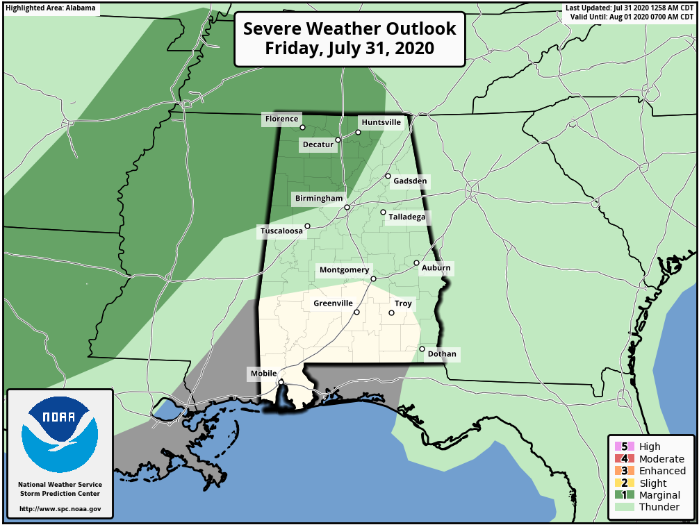
STRONG STORMS POSSIBLE LATER TODAY: The radar is quiet early this morning, but once again scattered showers and thunderstorms will form in the moisture laden airmass over Alabama this afternoon and tonight. An upper air system northwest of the state could help to produce a few strong thunderstorms; SPC has Northwest Alabama in a “marginal risk” (level 1/5) of severe thunderstorms later today. Some of the storms there could produce strong, gusty winds.
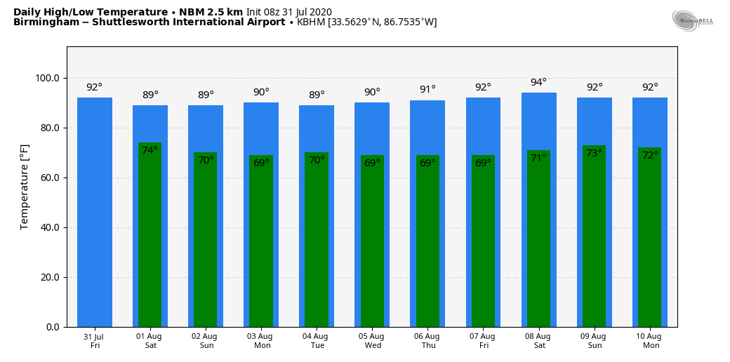
Otherwise, look for a mix of sun and clouds today with a high between 87 and 91 degrees.
THE ALABAMA WEEKEND: Not much change tomorrow; partly sunny, hot, humid weather continues with scattered storms, mostly during the afternoon and evening hours. SPC maintains a “marginal risk” for the northern quarter of the state due to the potential for strong winds. Then, on Sunday, most of the state will be dry with only isolated showers and storms as we will be in the subsidence ring (sinking air) on the periphery of Hurricane Isaias, which will be passing well to the east of the state. Highs over the weekend will remain mostly between 87 and 91 degrees.
NEXT WEEK: Monday will be mostly dry thanks to the sinking air, but the rest of the week should feature routine summer weather. Partly sunny, hot, humid days with random, scattered, mostly afternoon and evening showers and thunderstorms. Highs will be between 88 and 93 degrees…. See the Weather Xtreme video for maps, graphics, and more details.
HURRICANE ISAIAS: Isaias was upgraded to a hurricane last night based on data from reconnaissance aircraft. Maximum sustained winds this morning are near 80 mph, and the center is about 380 miles southeast of Nassau in the Bahamas. A hurricane warning is in effect for the Bahamas, and a tropical storm watch is in effect for the East coast of Florida from Ocean Reef to Sebastian Inlet.
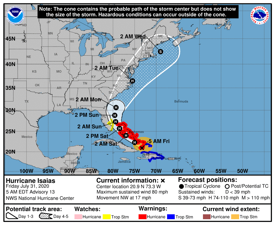
Tropical storm conditions are possible along portions of the Florida east coast beginning tomorrow. While storm surge watches are not currently needed for this area, they may be required later today if the forecast track shifts closer to the coast. Heavy rains associated with Isaias may begin to affect South Florida and east-Central Florida beginning late tonight, potentially resulting in isolated flash and urban flooding, especially in low-lying and poorly drained areas.
There is a risk of impacts from winds, heavy rainfall, and storm surge late this weekend from the northeastern Florida coast and spreading northward along the remainder of the U.S. east coast through early next week. The details of the track and intensity forecast remain uncertain, and it is too soon to determine the magnitude and location of these potential impacts, but interests along the entire U.S. east coast should monitor the progress of Isaias and updates to the forecast.
There will be no impact to Alabama or the Central Gulf Coast (including the area from Gulf Shores to Panama City Beach).
Elsewhere in the tropics, a tropical wave about halfway between the Lesser Antilles and the coast of Africa has a low chance of some development over the next 5 days. And, a wave in the far eastern Atlantic has a medium chance of development, but most likely it will be drifting northward instead of moving to the west.
There are no systems threatening the Gulf of Mexico for the next five to seven days.
ON THIS DATE IN 1997: South Pole, Antarctica recorded their coldest July ever. The average temperature of -86.8 degrees broke the previous record of -83.6 degrees set in July 1965
BEACH FORECAST: Click here to see the AlabamaWx Beach Forecast Center page.
WEATHER BRAINS: Don’t forget you can listen to our weekly 90 minute show anytime on your favorite podcast app. This is the show all about weather featuring many familiar voices, including our meteorologists here at ABC 33/40.
CONNECT: You can find me on all of the major social networks…
Facebook
Twitter
Instagram
Pinterest
Snapchat: spannwx
Look for the next Weather Xtreme video here by 4:00 this afternoon… enjoy the day!
Category: Alabama's Weather, ALL POSTS, Weather Xtreme Videos
About the Author (Author Profile)
James Spann is one of the most recognized and trusted television meteorologists in the industry. He holds the AMS CCM designation and television seals from the AMS and NWA. He is a past winner of the Broadcast Meteorologist of the Year from both professional organizations.Subscribe
If you enjoyed this article, subscribe to receive more just like it.


