

Strong Storms Affecting Parts of Tuscaloosa Co., Soon to Move Into Jefferson Co.
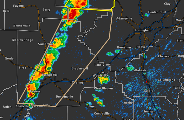
…SIGNIFICANT WEATHER ADVISORY FOR SOUTHEASTERN WALKER…CENTRAL
TUSCALOOSA AND SOUTHWESTERN JEFFERSON COUNTIES UNTIL 230 PM CDT…
At 138 PM CDT, Doppler radar was tracking strong thunderstorms along
a line extending from near Oakman to 7 miles west of Shelton State
Community College. Movement was east at 20 mph.
Dime size hail and winds in excess of 40 mph will be possible with
these storms.
Locations impacted include…
Tuscaloosa, Northport, Holt, Moundville, Brookwood, Coaling, Coker,
West Jefferson, Gorgas Steam Plant, Bull City, McFarland Mall,
Tuscaloosa Amphitheater, Tuscaloosa Regional Airport, Lake Wildwood,
Gorgas, Shelton State Community College, Bryant Denny Stadium,
University Mall, Deerlick Creek Campgrounds and Bankhead Lock And
Dam.
PRECAUTIONARY/PREPAREDNESS ACTIONS…
These storms may intensify, so be certain to monitor local radio
stations and available television stations for additional information
and possible warnings from the National Weather Service.
To report severe weather, contact your nearest law enforcement
agency. They will relay your report to the National Weather Service
office in Birmingham.
Category: Alabama's Weather, ALL POSTS, Severe Weather
About the Author (Author Profile)
Scott Martin is an operational meteorologist, professional graphic artist, musician, husband, and father. Not only is Scott a member of the National Weather Association, but he is also the Central Alabama Chapter of the NWA president. Scott is also the co-founder of Racecast Weather, which provides forecasts for many racing series across the USA. He also supplies forecasts for the BassMaster Elite Series events including the BassMaster Classic.Subscribe
If you enjoyed this article, subscribe to receive more just like it.


