

4:00 pm Isaias Update: A Hurricane Warning Issued for the Florida East Coast
SUMMARY OF 500 PM EDT…2100 UTC…INFORMATION
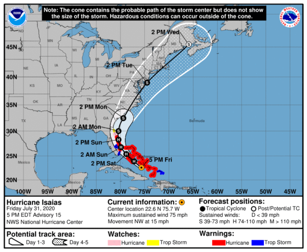
LOCATION…22.6N 75.7W
ABOUT 195 MI…320 KM SSE OF NASSAU
ABOUT 330 MI…535 KM SE OF FREEPORT GRAND BAHAMA ISLAND
MAXIMUM SUSTAINED WINDS…75 MPH…120 KM/H
PRESENT MOVEMENT…NW OR 305 DEGREES AT 15 MPH…24 KM/H
MINIMUM CENTRAL PRESSURE…991 MB…29.27 INCHES
WATCHES AND WARNINGS
A Hurricane Warning is in effect for…
* Boca Raton to the Volusia/Brevard County Line Florida
* Northwestern Bahamas
* Southeastern Bahamas
* Central Bahamas
A Hurricane Watch is in effect for…
* Hallendale Beach to south of Boca Raton Florida
* Volusia-Brevard County Line to the Flagler/Volusia County Line
A Storm Surge Watch is in effect for…
* Jupiter Inlet to Ponte Vedre Beach Florida
A Tropical Storm Warning is in effect for…
* Turks and Caicos Islands
* North of Ocean Reef to south of Boca Raton Florida
* Lake Okeechobee
A Tropical Storm Watch is in effect for…
* Flagler/Volusia County Line to Ponte Vedre Beach Florida
Interests elsewhere along the southeast coast of the United States should monitor the progress of Isaias. Additional watches or warnings may be required later tonight and Saturday.
FORECAST DISCUSSION
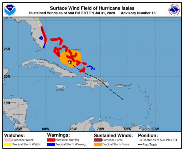
Deep convection, with occasional overshooting cloud tops of -85C to -90C just north of the center has continued to develop during the normal diurnal convective minimum period, which is quite impressive. The most recent Air Force Reserve recon flight-level wind data, along with ASCAT surface wind data, indicate that the inner-core and outer wind field have both contracted in size. Furthermore, radar data from the Bahamas and a 1810Z AMSR-2 microwave pass also indicate that a small 10-nmi-wide mid-level eye is forming. The last recon central pressure was 991 MB and the 700 MB height had decreased by 30 meters since the earlier maximum height around 1230Z. These data indicate that Isaias is getting better organized. The initial intensity remains 65 kt based on an earlier 700-MB flight-level wind speed of 72 kt, which reduces to a 65-kt surface wind speed using a 90-percent adjustment factor.
The initial motion remains northwestward or 305/12 kt. The 12Z global models have once again made a westward shift due to the ridge to the north of Isaias not weakening as quickly as expected. This is partly due to the ridge being stronger than expected and a shortwave trough over the central United States moving a little slower into the southeastern U.S. than previously indicated. The UKMET and ECMWF explicitly show Isaias making landfall in 36-48 hours along the southeast Florida coast, but appear to weaken the system below hurricane strength. The GFS similarly brings the cyclone close to the southeast and east-central Florida coasts, but also as a somewhat weaker system. In the 48 to 60-hour period, the cyclone is forecast to move slowly north-northwestward and northward through a break in the subtropical ridge extending westward from the Atlantic across Florida and into the northern Gulf of Mexico. By that time, however, Isaias is expected to weaken below hurricane strength due to the combination of strong southwesterly vertical wind shear and interaction with the Florida peninsula. Around 72 hours, the cyclone should accelerate northeastward and possibly strengthen some before passing over eastern North Carolina on day 4, and across eastern New England on day 5. The NHC track forecast lies close to a blend of the consensus models TVCA and NOAA-HCCA and is east of the UKMET and ECMWF with the system forecast to be stronger than those models indicate. Due to the westward shift in the NHC forecast track, a Hurricane Warning and Storm Surge Watch have been issued for portions of the Florida east coast.
The center of Isaias is now located in the center of an expanding CDO feature. The improved inner-core wind field and aforementioned convective structure, along with very warm SSTs near 30C, should support some strengthening overnight and early Saturday morning. However, increasing southwesterly vertical wind shear is expected to cause a gradual decrease in intensity by Sunday and continue into early next week. The new official intensity forecast is a little lower than the previous advisory and is near the higher end of the intensity guidance.
KEY MESSAGES
1. Hurricane conditions and dangerous storm surge are expected in portions of the Bahamas through Saturday, and Hurricane Warnings are in effect.
2. Hurricane conditions are expected along portions of the Florida east coast late Saturday and Saturday night, and a Hurricane Warning has been issued. Preparations to protect life and property should be rushed to completion.
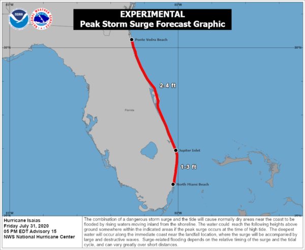
3. Dangerous storm surge is possible along the Florida east coast from Jupiter Inlet to Ponte Vedra Beach where water rises of 2 to 4 feet above ground level are possible along the immediate coastline and adjacent waterways. Residents in these areas should follow the advice given by local emergency officials.
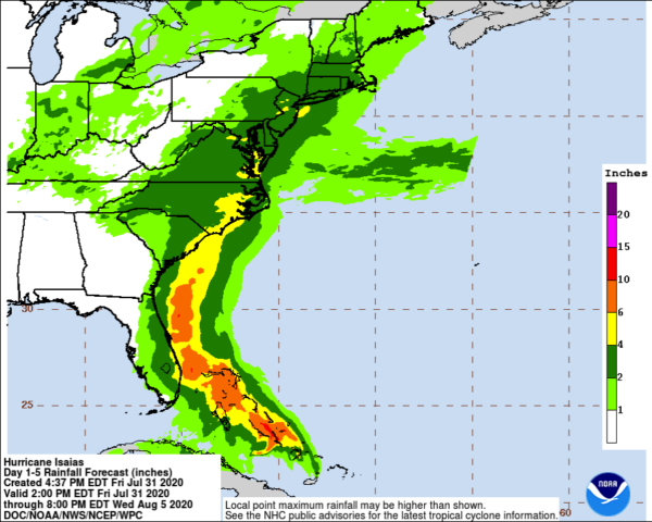
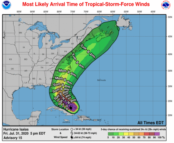
4. Isaias will produce heavy rains and potentially life-threatening flash and urban flooding, especially in low-lying and poorly drained areas across south to east-central Florida, and across the Carolinas to the mid-Atlantic. Isolated minor river flooding is possible across the eastern Carolinas and into Virginia early next week.
5. There is a risk of impacts from winds, heavy rainfall, and storm surge spreading along much of the U.S. east coast through early next week, and interests there should monitor the progress of Isaias and updates to the forecast.
Category: ALL POSTS, Severe Weather, Tropical
About the Author (Author Profile)
Scott Martin is an operational meteorologist, professional graphic artist, musician, husband, and father. Not only is Scott a member of the National Weather Association, but he is also the Central Alabama Chapter of the NWA president. Scott is also the co-founder of Racecast Weather, which provides forecasts for many racing series across the USA. He also supplies forecasts for the BassMaster Elite Series events including the BassMaster Classic.Subscribe
If you enjoyed this article, subscribe to receive more just like it.


