

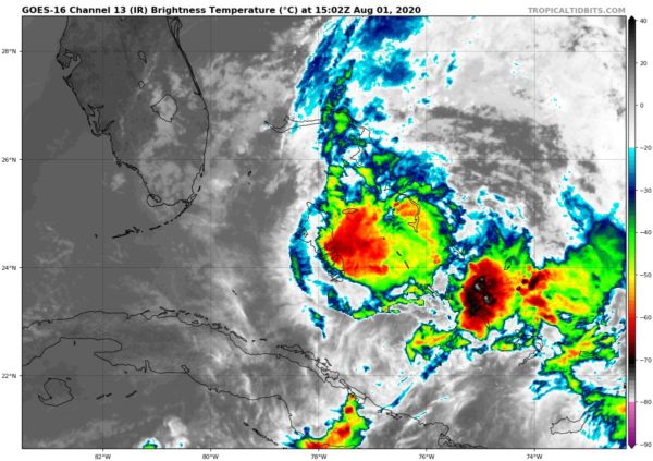
At 10:00 am, Isaias Making Landfall on Northern Andros Island
SUMMARY OF 1100 AM EDT…1500 UTC…INFORMATION
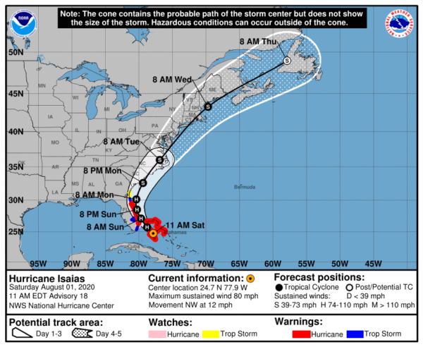
Location…24.7N 77.9W
About 40 mi…60 KM WSW of Nassau
About 135 mi…220 KM SSE of Freeport Grand Bahama Island
Maximum Sustained Winds…80 MPH…130 KM/H
Present Movement…NW or 315 degrees at 12 MPH…19 KM/H
Minimum Central Pressure…987 MB…29.15 inches
WATCHES AND WARNINGS
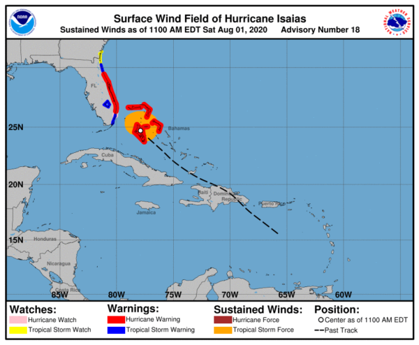
A Hurricane Warning is in effect for…
• Boca Raton to the Volusia/Flagler County Line Florida
• Northwestern Bahamas
A Hurricane Watch is in effect for…
• Hallandale Beach to the south of Boca Raton Florida
A Storm Surge Watch is in effect for…
• Jupiter Inlet to Ponte Vedra Beach Florida
A Tropical Storm Warning is in effect for…
• North of Ocean Reef to the south of Boca Raton Florida
• Lake Okeechobee
• Volusia/Flagler County Line to Ponte Vedra Beach Florida
A Tropical Storm Watch is in effect for…
• North of Ponte Vedra Beach Florida to Altamaha Sound Georgia
Interests elsewhere along the southeast coast of the United States should monitor the progress of Isaias. Additional watches or warnings may be required later today.
DISCUSSION AND OUTLOOK
At 1100 AM EDT (1500 UTC), the center of Hurricane Isaias was located by an Air Force Reserve Hurricane Hunter aircraft and Bahamas radar near latitude 24.7 North, longitude 77.9 West. Isaias is moving toward the northwest near 12 mph (19 km/h). A general northwestward motion with some decrease in forward speed is expected for the next day or so, followed by a north-northwestward motion by late Sunday. On the forecast track, the center of Isaias will move over northern Andros Island during the next few hours and move near or over Grand Bahama Island in the Northwestern Bahamas later today. Isaias is forecast to move near the east coast of the Florida peninsula tonight through Sunday.
Reports from the reconnaissance aircraft indicate that maximum sustained winds have decreased slightly to near 80 mph (130 km/h) with higher gusts. Little change in strength is expected through Sunday, and Isaias is forecast to remain a hurricane during this time. Slow weakening is expected to begin by late Monday.
Hurricane-force winds extend outward up to 25 miles (35 km) from the center and tropical-storm-force winds extend outward up to 115 miles (185 km). Reports from a U.S. Navy site on Andros Island indicate that sustained winds of 45 mph (76 km/h) and a gust to 69 mph (111 km/h) occurred about 3 hours ago. More recently, a sustained wind of 35 mph (56 km/h) and a gust to 48 mph (77 km/h) were measured at Nassau, Bahamas.
The estimated minimum central pressure is 987 MB (29.15 inches).
HAZARDS AFFECTING LAND
STORM SURGE: The combination of a dangerous storm surge and the tide will cause normally dry areas near the coast to be flooded by rising waters moving inland from the shoreline. The water could reach the following heights above ground somewhere in the indicated areas if the peak surge occurs at the time of high tide…
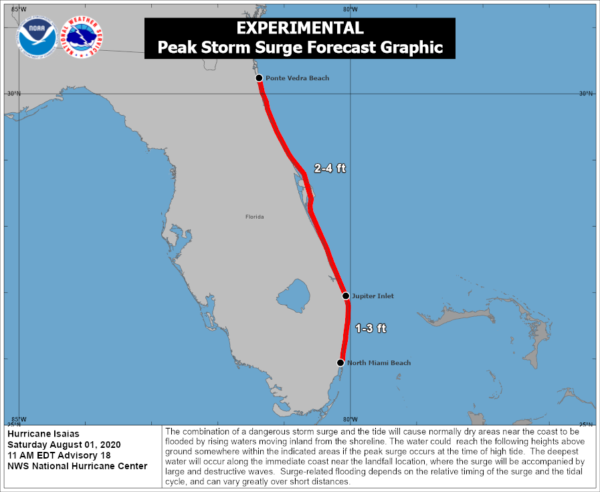
• Jupiter Inlet to Ponte Vedra Beach FL…2-4 ft
• North Miami Beach to Jupiter Inlet FL…1-3 ft
The deepest water will occur along the immediate coast near and to the right of the center, where the surge will be accompanied by large waves. Surge-related flooding depends on the relative timing of the surge and the tidal cycle and can vary greatly over short distances.
A dangerous storm surge will raise water levels by as much as 3 to 5 feet above normal tide levels in areas of onshore winds in the Northwestern Bahamas.
WIND: Hurricane conditions will continue to spread over the Northwestern Bahamas through today.
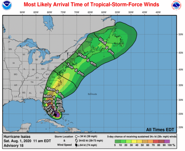
Hurricane conditions are expected to reach the coast within the hurricane warning area in Florida tonight and will spread northward through Sunday. Winds are expected to first reach tropical storm strength later today, making outside preparations difficult or dangerous. Preparations to protect life and property should be rushed to completion. Tropical storm conditions are expected within the tropical storm warning area, and are possible within the watch area, over southern Florida by this afternoon or evening.
Tropical storm conditions are expected in the warning area in northeast Florida by late Sunday and are possible in the watch area in northeast Florida and southeast Georgia by Monday morning.
RAINFALL: Isaias is expected to produce the following rain accumulations:
• Bahamas: 4 to 8 inches
• Cuba: 1 to 2 inches, with isolated maximum totals of 4 inches
These rainfall amounts could lead to life-threatening flash and urban flooding, especially in low-lying and poorly drained areas.
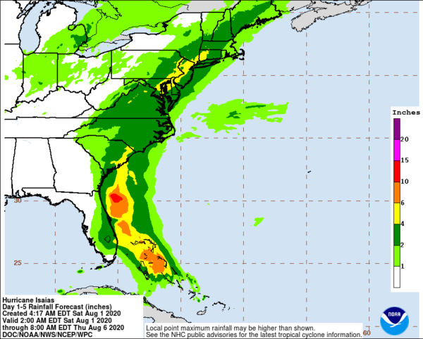
From Friday night through Tuesday:
• South Florida into east-central Florida: 2 to 4 inches, with isolated maximum totals of 6 inches
• Northeast Florida into coastal Georgia: 1 to 2 inches
• Carolinas into the mid-Atlantic, including the southern and central Appalachians: 2 to 4 inches, with isolated maximum totals of 6 inches
Heavy rainfall from Isaias could result in potentially life-threatening flash and urban flooding, especially in low-lying and poorly drained areas. Minor river flooding is possible across portions of the Carolinas and Virginia.
SURF: Swells generated by Isaias are affecting portions of Hispaniola, eastern Cuba, the Turks and Caicos, and the Bahamas.
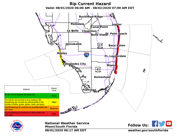
These swells will spread along the east coast of Florida and the southeastern United States coast today. These swells are likely to cause life-threatening surf and rip current conditions.
Category: ALL POSTS, Severe Weather, Tropical
About the Author (Author Profile)
Scott Martin is an operational meteorologist, professional graphic artist, musician, husband, and father. Not only is Scott a member of the National Weather Association, but he is also the Central Alabama Chapter of the NWA president. Scott is also the co-founder of Racecast Weather, which provides forecasts for many racing series across the USA. He also supplies forecasts for the BassMaster Elite Series events including the BassMaster Classic.Subscribe
If you enjoyed this article, subscribe to receive more just like it.


