

An Early Morning Look at Isaias
We are tracking Hurricane Isaias this morning as it scrapes along the East Coast of Florida, getting ready to travel virtually the entire length of the U.S. East Coast. Fortunately, dry air and wind shear have been taking a toll on the storm and it is a shadow of what it might have been otherwise. Here’s the latest on…
ISAIAS AS OF 4 AM CDT
SUMMARY OF 500 AM EDT…0900 UTC…INFORMATION
———————————————-
LOCATION…26.3N 79.5W
ABOUT 45 MI…75 KM ENE OF FORT LAUDERDALE FLORIDA
ABOUT 45 MI…75 KM SE OF WEST PALM BEACH FLORIDA
MAXIMUM SUSTAINED WINDS…65 MPH…100 KM/H
PRESENT MOVEMENT…NW OR 325 DEGREES AT 9 MPH…15 KM/H
MINIMUM CENTRAL PRESSURE…996 MB…29.42 INCHES
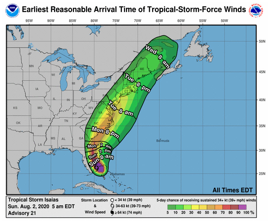
…Isaias did weaken yesterday and has not been able to make much of a comeback overnight. The system has managed a couple of bursts of intense convection, but it is not being translated into intensity because of strong wind shear. Air Force reconnaissance is finding that top winds are 65 mph this morning. The storm is still plodding northwestward at 9 mph, from a position 45 miles southeast of West Palm Beach. It will take all day today for it to clear the Florida coast. The hurricane warnings have been dropped in favor of tropical storm warnings to north of Charleston, with a tropical storm watch northward to north of Wilmington, North Carolina.
FUTURE TRACK: Isaias will brush the Florida coast today and male landfall again likely on the South Carolina coast near Myrtle Beach Monday night as a 65 mph tropical storm. It should accelerate north-northeastward through the Mid-Atlantic on Tuesday and into New England Tuesday night into Wednesday.
RAINFALL THREAT: Heavy rains will be a problem along the track of Isaias, especially over the Carolinas tomorrow up through the Mid-Atlantic on Tuesday. Amounts could approach 5-8 inches.
ITS IMPACT ON ALABAMA: Zero. Our weather and the path of the hurricane over the next few days will be impacted by an unusual upper-level trough that extends from the Midwest to the Texas Coast. The trough is opening a channel for the hurricane to escape between high pressure to the west and the Bermuda High to the east over the Atlantic. The trough also allowed a cold front to push through the northern half of Alabama overnight. Much drier air will sink down to about I-59 by this afternoon. You won’t notice less humidity, and about the only thing you will notice differently are the northerly winds. There may be an isolated shower or storm south of I-59 this afternoon, but the chance is small. Highs this afternoon will be upper 80s over North Alabama, near 90F in the I-20 Corridor, and in the lower 90s to the south. Lows tonight will be in the middle 60s up north, upper 60s over North Central Alabama.
The video will be up before 7. We will have coverage of Isaias throughout the day and the week ahead.
About the Author (Author Profile)
Bill Murray is the President of The Weather Factory. He is the site's official weather historian and a weekend forecaster. He also anchors the site's severe weather coverage. Bill Murray is the proud holder of National Weather Association Digital Seal #0001 @wxhistorianSubscribe
If you enjoyed this article, subscribe to receive more just like it.


