

Sunday Weather Xtreme Video: Isaias Scrapes Florida Today and Monday Heading Northward; Dry Week for Alabama
We are tracking Hurricane Isaias this morning as it scrapes along the East Coast of Florida, getting ready to travel virtually the entire length of the U.S. East Coast. Fortunately, dry air and wind shear have been taking a toll on the storm and it is a shadow of what it might have been otherwise. Here’s the latest on…
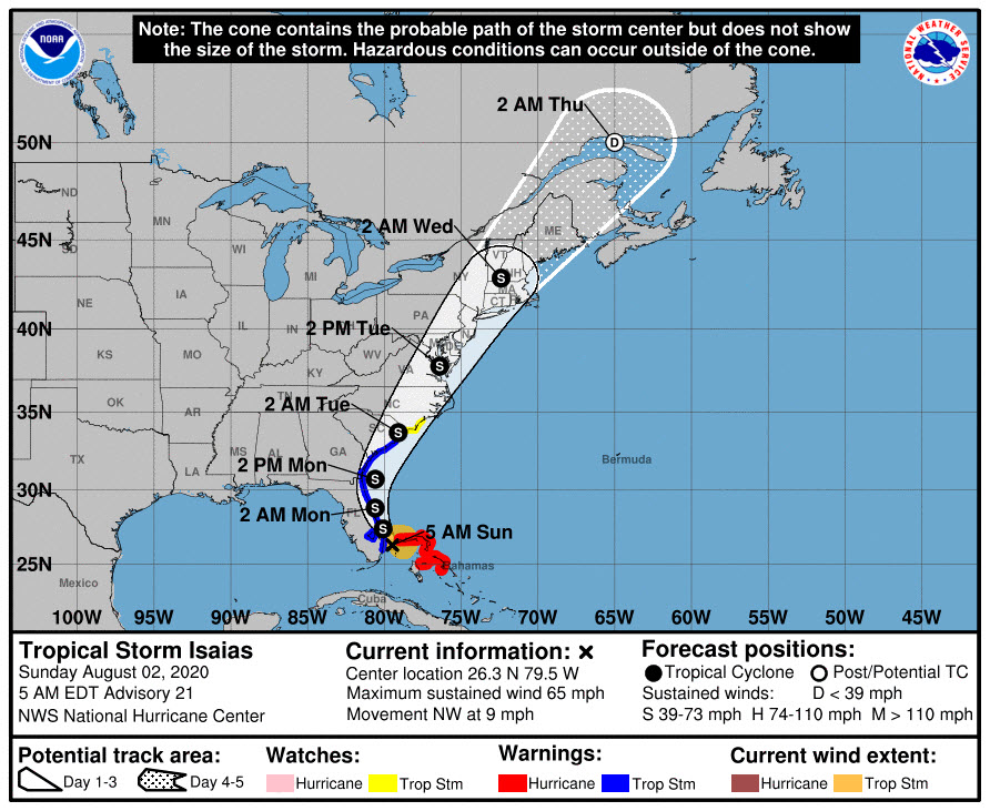
ISAIAS AS OF 4 AM CDT…Isaias did weaken yesterday and has not been able to make much of a comeback overnight. The system has managed a couple of bursts of intense convection, but it is not being translated into intensity because of strong wind shear. Air Force reconnaissance is finding that top winds are 65 mph this morning. The storm is still plodding northwestward at 9 mph, from a position 45 miles southeast of West Palm Beach. It will take all day today and much of tomorrow for it to clear the Florida coast. The hurricane warnings have been dropped in favor of tropical storm warnings to north of Charleston, with a tropical storm watch northward to north of Wilmington, North Carolina.
FUTURE TRACK: Isaias will brush the Florida coast today and make landfall again likely on the South Carolina coast near Myrtle Beach Monday night as a 65 mph tropical storm. It should accelerate north-northeastward through the Mid-Atlantic on Tuesday and into New England Tuesday night into Wednesday.
RAINFALL THREAT: Heavy rains will be a problem along the track of Isaias, especially over the Carolinas tomorrow up through the Mid-Atlantic on Tuesday. Amounts could approach 5-8 inches.
ITS IMPACT ON ALABAMA: Zero. Our weather and the path of the hurricane over the next few days will be impacted by an unusual upper-level trough that extends from the Midwest to the Texas Coast. The trough is opening a channel for the hurricane to escape between high pressure to the west and the Bermuda High to the east over the Atlantic. The trough also allowed a cold front to push through the northern half of Alabama overnight. Much drier air will sink down to about I-59 by this afternoon. You won’t notice less humidity, and about the only thing you will notice differently are the northerly winds. There may be an isolated shower or storm south of I-59 this afternoon, but the chance is small. Highs this afternoon will be upper 80s over North Alabama, near 90F in the I-20 Corridor, and in the lower 90s to the south. Lows tonight will be in the middle 60s up north, upper 60s over North Central Alabama.
MONDAY – FRIDAY: The trough will establish itself over the eastern United States for the coming week. And this will allow for some unusual July weather across Alabama. It will be partly cloudy. It will be slightly cooler than normal (a couple of degrees each day). It will be a teeny bit less humid (hardly noticeable). There will be only isolated showers and storms each day. Highs will be in the upper 80s to lower 90s, warming toward the end of the week. Lows will be in the middle 60s at midweek, rising back too the upper 60s by Friday morning.
THE WEEKEND: It will be heating up by Saturday and Sunday, with highs returning to the middle 90s. A slight chance of afternoon and evening showers and storms will return along with the heat.
VOODOO TERRITORY: That following week will feature a return to a fairly normal summertime pattern of scattered afternoon and evening showers and storms each day. Highs will be in the 90s, and lows in the 70s.
ELSEWHERE IN THE TROPICS: Tropical depression ten dissipated late last night over the far eastern Atlantic. The NHC is watching Invest 94L northeast of the Lesser Antilles. It should move northwest into the void left by Isaias and perhaps pass between the U.S. and Bermuda.
GULF COAST WEATHER: A fairly typical week along the beautiful beaches of Alabama and Northwest Florida. Sunny to partly cloudy skies each day with a chance of showers and storms on some days, a couple will be mainly dry. It will be warm and humid, with highs in the upper 80s and lowers in the upper 70s. Water temperatures are in the lower 80s. The rip current risk is low, with surf running around 1 foot.
DANCING WITH THE STATS: July tied the record for the number of named storms that formed during the month…five. The previous record was established in 2005. You remember that year, right? Usually, by the first of August, we have seen only 1 or 2 named storms. We are up to the “I” storm, something we wouldn’t normally see until October. We track something called ACE, or Accumulated Cyclone Energy, which measures the strength and duration of tropical storms and hurricanes. So far this year in the Atlantic, the ACE total stands at 17.9. It normally would be around 7.7 by July 31st. Nine named storms and two hurricanes so far this year. With Isaias appearing to be heading for an eventual U.S. landfall, it appears that both our hurricanes so far this season will record U.S. landfalls.
WEATHERBRAINS: We’re very excited this week to have author Eric Jay Dolan, whose book “Furious Sky: A 500 Year History of America’s Hurricanes” will be our guest. We will record Monday evening at 8 p.m. CDT. Check out the show at www.WeatherBrains.com. You can also subscribe on iTunes. You can watch the show live at: http://live.bigbrainsmedia.com/ You will be able to see the show on the James Spann 24×7 weather channel on cable or directly over the air on the dot 2 feed.
ON THIS DATE IN 1985: A Delta Airlines jet crashed during a thunderstorm on approach to the Dallas Fort Worth International Airport, killing 135 people. The accident prompted major efforts to find ways to detect and avoid wind shear. Since then, only one major U.S. crash has involved wind shear, a USAir crash in Charlotte, NC on July 2, 1994. Follow my weather history tweets on Twitter. I am @wxhistorian at Twitter.com.
Category: Alabama's Weather, ALL POSTS, Tropical
About the Author (Author Profile)
Bill Murray is the President of The Weather Factory. He is the site's official weather historian and a weekend forecaster. He also anchors the site's severe weather coverage. Bill Murray is the proud holder of National Weather Association Digital Seal #0001 @wxhistorianSubscribe
If you enjoyed this article, subscribe to receive more just like it.


