

Isaias Nearing Hurricane Strength Once Again; Continues Journey North-Northwestward Just Offshore
SUMMARY OF 500 PM EDT…2100 UTC…INFORMATION
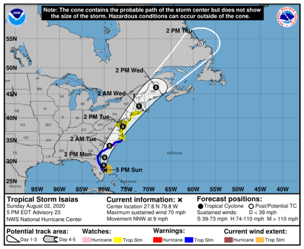
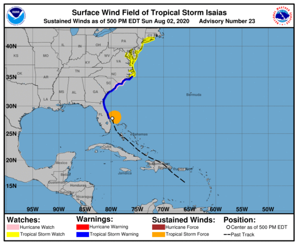
LOCATION…27.8N 79.8W
ABOUT 65 MI…105 KM SE OF CAPE CANAVERAL FLORIDA
ABOUT 410 MI…660 KM S OF MYRTLE BEACH SOUTH CAROLINA
MAXIMUM SUSTAINED WINDS…70 MPH…110 KM/H
PRESENT MOVEMENT…NNW OR 345 DEGREES AT 9 MPH…15 KM/H
MINIMUM CENTRAL PRESSURE…994 MB…29.36 INCHES
SUMMARY OF WATCHES AND WARNINGS IN EFFECT
A Storm Surge Warning is in effect for…
* Edisto Beach South Carolina to Cape Fear North Carolina
A Storm Surge Watch is in effect for…
* Cape Fear to Duck North Carolina
* Pamlico and Albemarle Sounds
A Hurricane Watch is in effect for…
* South Santee River South Carolina to Surf City North Carolina
A Tropical Storm Warning is in effect for…
* Sebastian Inlet Florida to Ocracoke Inlet North Carolina
A Tropical Storm Watch is in effect for…
* Ocracoke Inlet North Carolina to Watch Hill Rhode Island
* Pamlico and Albemarle Sounds
* Chesapeake Bay
* Tidal Potomac River
* Delaware Bay
* Long Island and Long Island Sound
FORECAST DISCUSSION
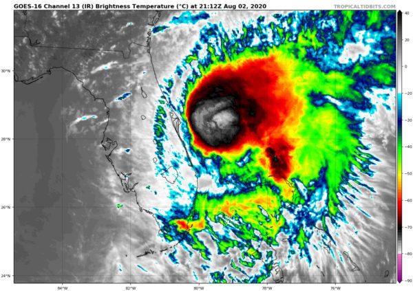
The earlier intense recent burst has waned since this morning, but the large convective cell has persisted. At the peak of the activity around 1500Z, several small patches of Doppler velocities of 90-96 kt were co-located with the pronounced mid-level circulation that was evident in the Melbourne radar reflectivity data. However, these intense wind speed values were short-lived for only about 20 minutes and, thus, were not considered to representative of Isaias’ tangential wind field. Since that time, the cyclone has become more steady-state with Doppler radar and Air Force Reserve aircraft data indicating surface winds in the 56-63 kt range. Therefore, the initial intensity of 60 kt is an average of these values.
Radar and aircraft fixes indicate that Isaias is still moving toward the north-northwest or 345/08 kt. The latest model guidance remains in excellent agreement on Isaias moving north-northwestward through a break in the subtropical ridge tonight and turning northward by Monday morning, all the while remaining offshore of the coast from east-central Florida to Georgia. By Monday night, Isaias is forecast to turn northeastward and accelerate toward the Carolinas, reaching the mid-Atlantic states on Tuesday and New England by early Wednesday. The new NHC forecast track during the first 24 hours lies a little east of the previous one, but is essentially just an extension of the previous advisory track thereafter, and lies close to the various consensus models, which are lightly packed around the previous NHC forecast.
Isaias will continue to move slowly over the warm Gulfstream waters for the next 36 h or so. Despite unfavorable vertical shear conditions of around 25 kt, Isaias is expected to maintain its current intensity until landfall and could restrengthen to hurricane status in 24-36 h when the vertical shear vector is forecast to switch from westerly to southwesterly which would align the shear along the direction of storm motion. Some baroclinic interaction is expected on days 2-3 when Isaias will move into the right-rear quadrant of an anticyclonically curved jet streak, which is expected to hold the intensity a little above what would normally be expected for a post-landfall tropical cyclone. The NHC intensity forecast is similar to the HFIP corrected consensus model and the IVCN intensity consensus model, which agree well with the GFS and ECMWF model intensity forecasts.
KEY MESSAGES
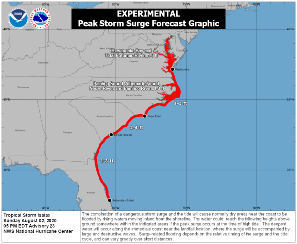
1. There is the danger of life-threatening storm surge inundation of 2 to 4 feet above ground level from Edisto Beach South Carolina to Cape Fear North Carolina along the immediate coastline and adjacent waterways. Life-threatening storm surge is possible along the North Carolina coast from Cape Fear to Duck. Residents in these areas should follow the advice given by local emergency officials.
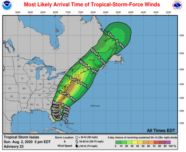
2. Tropical storm conditions will spread northward within the Tropical Storm Warning area from Florida to North Carolina through Monday night. Isaias is expected to be near hurricane strength when it reaches the coast of northern South Carolina and southern North Carolina Monday night, and strong tropical-storm-force winds are likely with hurricane conditions possible in the Hurricane Watch area.
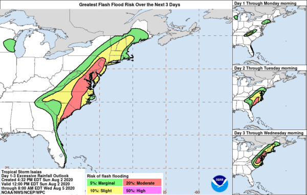
3. Heavy rainfall from Isaias will continue to result in potentially life-threatening flash flooding in the Northwest Bahamas through tonight. Flash and urban flooding, some of which may be significant in the eastern Carolinas and the mid-Atlantic, are expected through midweek along and near the path of Isaias across the U.S. East Coast. Widespread minor to isolated moderate river flooding is possible across portions of the Carolinas and the mid-Atlantic.
4. A tropical storm watch is in effect for the U.S. mid-Atlantic coast, including the Chesapeake Bay, Delaware Bay, and Long Island Sound, as tropical-storm-force winds are possible in these areas on Tuesday and Tuesday night. Additional watches and warnings will likely be issued tonight and Monday as Isaias is expected to move northward near or over the mid-Atlantic and New England states Tuesday and Wednesday.
Category: ALL POSTS, Severe Weather, Tropical
About the Author (Author Profile)
Scott Martin is an operational meteorologist, professional graphic artist, musician, husband, and father. Not only is Scott a member of the National Weather Association, but he is also the Central Alabama Chapter of the NWA president. Scott is also the co-founder of Racecast Weather, which provides forecasts for many racing series across the USA. He also supplies forecasts for the BassMaster Elite Series events including the BassMaster Classic.Subscribe
If you enjoyed this article, subscribe to receive more just like it.


