

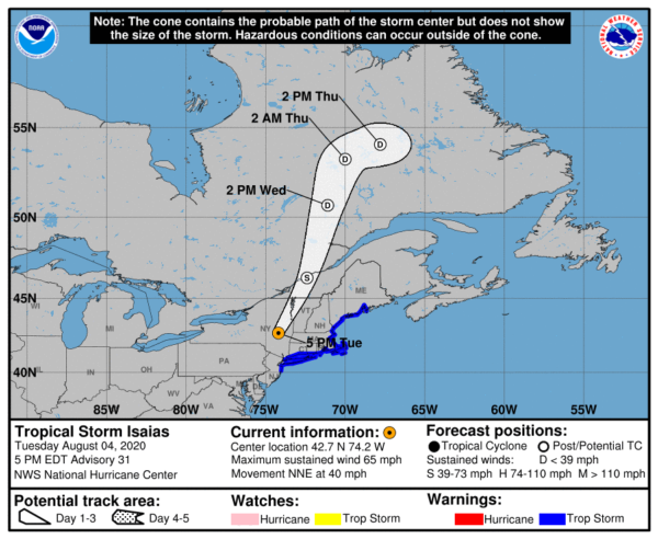
Isaias Racing North-Northeastward Across Eastern New York
SUMMARY OF 500 PM EDT…2100 UTC…INFORMATION
LOCATION…42.7N 74.2W
ABOUT 20 MI…35 KM W OF ALBANY NEW YORK
MAXIMUM SUSTAINED WINDS…65 MPH…100 KM/H
PRESENT MOVEMENT…NNE OR 20 DEGREES AT 40 MPH…65 KM/H
MINIMUM CENTRAL PRESSURE…995 MB…29.39 INCHES
SUMMARY OF WATCHES AND WARNINGS IN EFFECT
A Tropical Storm Warning is in effect for…
* Manasquan Inlet New Jersey to Stonington Maine
* Long Island and Long Island Sound
* Martha’s Vineyard, Nantucket, and Block Island
DISCUSSION AND OUTLOOK
At 500 PM EDT (2100 UTC), the center of Tropical Storm Isaias was located by NOAA Doppler weather radars and surface observations near latitude 42.7 North, longitude 74.2 West. Isaias is moving toward the north-northeast near 40 mph (65 km/h), and this general motion is expected through tonight. On the forecast track, the center of Isaias will continue to move farther inland over eastern New York and Vermont this afternoon and evening, and over southern Canada tonight.
Data from Doppler weather radars along with surface observations indicate that maximum sustained winds have decreased to near 65 mph (100 km/h) with higher gusts. Gradual weakening is expected this afternoon and evening, followed by a faster rate of weakening tonight. Isaias is forecast to become post-tropical tonight or early Wednesday.
Tropical-storm-force winds extend outward up to 205 miles (335 km) from the center. During the past hour, a NOAA NOS observing site at Sandy Hook, New Jersey, reported a sustained wind 41 mph (67 km/h) and a gust to 50 mph (80 km/h). Wind gusts in excess of 50 mph (80 km/h) have also been reported at multiple sites in southeastern New York, Connecticut, Rhode Island, and Massachusetts during the past hour.
The estimated minimum central pressure based on surface observations is 995 MB (29.39 inches).
KEY MESSAGES
STORM SURGE: The combination of storm surge and the tide will cause normally dry areas near the coast to be flooded by rising waters moving inland from the shoreline. The water could reach the following heights above ground somewhere in the indicated areas if the peak surge occurs at the time of high tide…
Sandy Hook NJ to Martha’s Vineyard MA including Long Island Sound, Block Island Sound, Narragansett Bay, Buzzards Bay, and Vineyard Sound…1-2 ft
WIND: Widespread tropical-storm conditions are expected in the tropical storm warning area in eastern New York, Long Island, and southern New England, with wind gusts to hurricane force possible. These winds could cause significant tree damage and power outages. Tropical storm conditions are expected to reach southern New England by late afternoon and reach northern New England tonight. Gale-force winds are expected to spread into southeastern Quebec tonight and Wednesday.
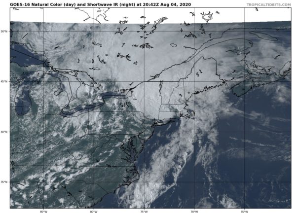
RAINFALL: Heavy rainfall near the path of Isaias, through the Hudson River Valley, is likely to result in flash flooding, particularly through urban areas and the surrounding terrain of the Catskills, Adirondack, and Green Mountain Ranges through Tuesday night. Scattered minor to moderate river flooding is likely across portions of the Mid-Atlantic. Quick-responding rivers in the Northeast will also be susceptible to minor and possible moderate river flooding.
TORNADOES: A couple of tornadoes are possible across southern New England late this afternoon. A risk for tornadoes may continue and spread across parts of northern New England through this evening.
SURF: Swells generated by Isaias will spread northward along the mid-Atlantic and Northeast coasts of the United States today. These swells are likely to cause life-threatening surf and rip current conditions.
All information from the National Hurricane Center’s 4:00 pm CDT Update.
Category: ALL POSTS, Severe Weather, Tropical
About the Author (Author Profile)
Scott Martin is an operational meteorologist, professional graphic artist, musician, husband, and father. Not only is Scott a member of the National Weather Association, but he is also the Central Alabama Chapter of the NWA president. Scott is also the co-founder of Racecast Weather, which provides forecasts for many racing series across the USA. He also supplies forecasts for the BassMaster Elite Series events including the BassMaster Classic.Subscribe
If you enjoyed this article, subscribe to receive more just like it.


