

Strong Storms Moving Across Southeastern Jefferson County
Special Weather Statement
National Weather Service Birmingham AL
503 PM CDT Fri Aug 7 2020
…SIGNIFICANT WEATHER ADVISORY FOR SOUTHEASTERN JEFFERSON COUNTY
UNTIL 545 PM CDT…
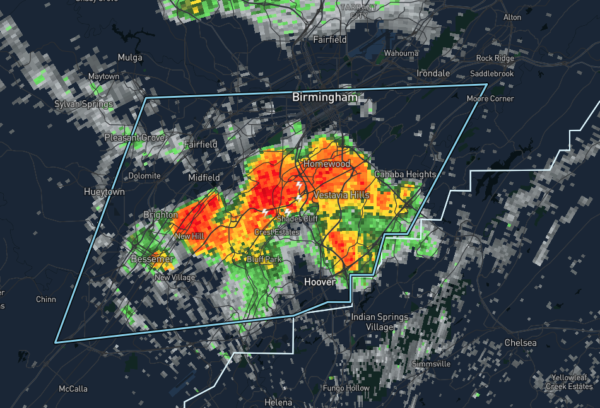
At 503 PM CDT, Doppler radar was tracking strong thunderstorms along
a line extending from Lipscomb to Homewood. These storms were nearly
stationary.
Half inch hail and winds in excess of 40 mph will be possible with
these storms.
Locations impacted include…
Birmingham, Hoover, Vestavia Hills, Bessemer, Homewood, Mountain
Brook, Hueytown, Irondale, Fairfield, Pleasant Grove, Midfield,
Brighton, Lipscomb, Birmingham Fairgounds, B.j.c.c., Five Points
South, Ensley, Bluff Park, Legion Field and U.A.B. Campus.
PRECAUTIONARY/PREPAREDNESS ACTIONS…
Torrential rainfall is also occurring with these storms, and may lead
to localized flooding. Do not drive your vehicle through flooded
roadways.
Frequent cloud to ground lightning is occurring with these storms.
Lightning can strike 10 miles away from a thunderstorm. Seek a safe
shelter inside a building or vehicle.
These storms may intensify, so be certain to monitor local radio
stations and available television stations for additional information
and possible warnings from the National Weather Service.
Category: Alabama's Weather, ALL POSTS, Severe Weather
About the Author (Author Profile)
Scott Martin is an operational meteorologist, professional graphic artist, musician, husband, and father. Not only is Scott a member of the National Weather Association, but he is also the Central Alabama Chapter of the NWA president. Scott is also the co-founder of Racecast Weather, which provides forecasts for many racing series across the USA. He also supplies forecasts for the BassMaster Elite Series events including the BassMaster Classic.Subscribe
If you enjoyed this article, subscribe to receive more just like it.


