

EXPIRED Flood Advisory for Parts of Cherokee County Until 5:00 pm
THE NATIONAL WEATHER SERVICE IN BIRMINGHAM HAS ISSUED A
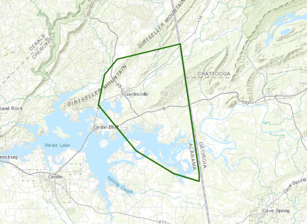
* FLOOD ADVISORY FOR…
EAST CENTRAL CHEROKEE COUNTY IN NORTHEASTERN ALABAMA…
* UNTIL 500 PM CDT.
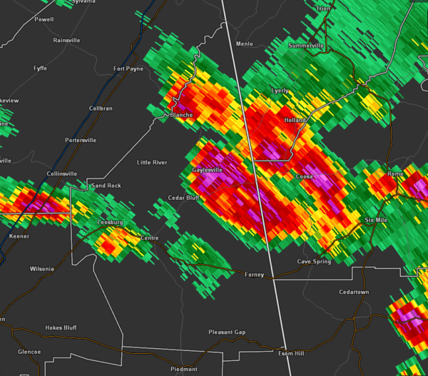
* AT 256 PM CDT, DOPPLER RADAR INDICATED HEAVY RAIN DUE TO
THUNDERSTORMS. MINOR FLOODING IS ONGOING OR EXPECTED TO BEGIN
SHORTLY IN THE ADVISORY AREA. BETWEEN 1 AND 2 INCHES OF RAIN HAVE
FALLEN OVER THE PAST HOUR, OR SO.
SOME LOCATIONS THAT WILL EXPERIENCE FLOODING INCLUDE…
CEDAR BLUFF, GAYLESVILLE, CORNWALL FURNACE PARK, EASTERN WEISS
LAKE, WATERHOUSE AND FULLERTON.
PRECAUTIONARY/PREPAREDNESS ACTIONS…
TURN AROUND, DON’T DROWN WHEN ENCOUNTERING FLOODED ROADS. MOST FLOOD
DEATHS OCCUR IN VEHICLES.
Category: Alabama's Weather, ALL POSTS, Severe Weather
About the Author (Author Profile)
Scott Martin is an operational meteorologist, professional graphic artist, musician, husband, and father. Not only is Scott a member of the National Weather Association, but he is also the Central Alabama Chapter of the NWA president. Scott is also the co-founder of Racecast Weather, which provides forecasts for many racing series across the USA. He also supplies forecasts for the BassMaster Elite Series events including the BassMaster Classic.Subscribe
If you enjoyed this article, subscribe to receive more just like it.


