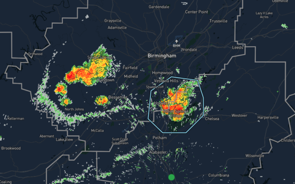
Strong Storms Affecting Parts of Jefferson & Shelby Counties

…SIGNIFICANT WEATHER ADVISORY FOR CENTRAL SHELBY AND SOUTHEASTERN
JEFFERSON COUNTIES UNTIL 630 PM CDT…
At 559 PM CDT, Doppler radar was tracking a strong thunderstorm over
Indian Springs Village, or near Hoover. This storm was nearly
stationary.
Pea size hail and winds in excess of 40 mph will be possible with
this storm.
Locations impacted include…
Hoover, Vestavia Hills, Pelham, Helena, Chelsea, Indian Springs
Village, Riverchase, Patton Creek, Oak Mountain State Park, Hoover
Metropolitan Stadium, The Summit, Riverchase Galleria, Oak Mountain
Amphitheater, Meadowbrook, Cahaba Heights, Brook Highland and Hoover
Veterans Park.
PRECAUTIONARY/PREPAREDNESS ACTIONS…
Torrential rainfall is also occurring with this storm, and may lead
to localized flooding. Do not drive your vehicle through flooded
roadways.
Frequent cloud to ground lightning is occurring with this storm.
Lightning can strike 10 miles away from a thunderstorm. Seek a safe
shelter inside a building or vehicle.
This storm may intensify, so be certain to monitor local radio
stations and available television stations for additional information
and possible warnings from the National Weather Service.
Category: Alabama's Weather, ALL POSTS, Severe Weather


