

Scattered To Numerous Showers/Storms Later Today
UNSETTLED SUMMER WEATHER: Hot, humid weather continues across Alabama today, and in the unstable air we expect scattered to numerous showers and thunderstorms this afternoon and early tonight. Most of the showers will come from about 1:00 until 11:00 p.m., and like recent days some neighborhoods will see heavy rain and gusty winds with the stronger thunderstorms. Otherwise, look for a mix of sun and clouds today with a high mostly in the low 90s.
REST OF THE WEEK: Not much change tomorrow and Friday; the sky will be occasionally cloudy with a few passing showers and storms likely both days, mostly during the afternoon and evening hours. On the positive side, heat levels come down with highs in the 87-90 degree range both days.
THE ALABAMA WEEKEND: Showers should become fewer in number Saturday as the drier air creeps into the state, and most places will be dry Sunday with only isolated showers. Look for a decent amount of sun both days with afternoon highs around 90 degrees.
NEXT WEEK: A broad upper trough forms over the eastern half of the nation, and we are expecting below average temperatures for August with highs in the 80s and lows in the 60s most days. A few scattered showers are possible Monday and Tuesday, and only isolated showers are expected over the latter half of the week. See the Weather Xtreme video for maps, graphics, and more details.

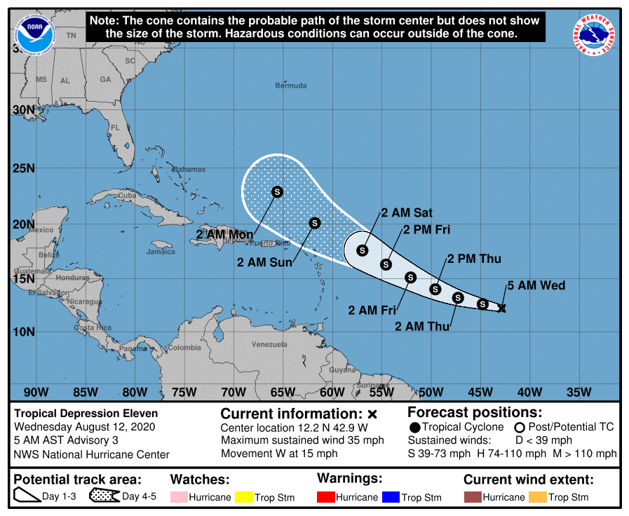
TROPICS: Tropical Depression 11, in the Atlantic about halfway between Africa and the Lesser Antilles, is expected to become Tropical Storm Josephine later today. It is expected to remain below hurricane strength over the next five days due to dry air surrounding the system and wind shear; it should be north of Puerto Rico by Monday of next week as it gains latitude. If the system survives, it is most likely going to recurve well east of the U.S. The rest of the Atlantic basin, including the Gulf of Mexico, remains quiet.
ON THIS DATE IN 1955: Hurricane Connie made landfall on the North Carolina coast a category two strength. Ahead of the storm, the United States Weather Bureau issued widespread hurricane warnings, spurring evacuations, flight cancelations, and beach closures. Connie produced strong winds, high tides, and heavy rainfall as it moved ashore, causing heavy crop damage and 27 deaths in North Carolina. Four people were killed in Washington, D.C. due to a traffic accident caused by slick roads. In Chesapeake Bay, Connie capsized a boat, killing 14 people and prompting a change in Coast Guard regulations. There were six deaths each in Pennsylvania and New Jersey, and 14 deaths in New York, where record rainfall flooded houses and subways. At least 295,000 people nationwide lost electric power during the storm. Damage in the United States totaled around $86 million (1955 USD).
BEACH FORECAST: Click here to see the AlabamaWx Beach Forecast Center page.
WEATHER BRAINS: Don’t forget you can listen to our weekly 90 minute show anytime on your favorite podcast app. This is the show all about weather featuring many familiar voices, including our meteorologists here at ABC 33/40.
CONNECT: You can find me on all of the major social networks…
Facebook
Twitter
Instagram
Pinterest
Snapchat: spannwx
Look for the next Weather Xtreme video here by 4:00 this afternoon….
Category: Alabama's Weather, ALL POSTS, Weather Xtreme Videos
About the Author (Author Profile)
James Spann is one of the most recognized and trusted television meteorologists in the industry. He holds the AMS CCM designation and television seals from the AMS and NWA. He is a past winner of the Broadcast Meteorologist of the Year from both professional organizations.Subscribe
If you enjoyed this article, subscribe to receive more just like it.


