

CANCELED Severe T-Storm Warning for Parts of Elmore & Montgomery Counties Until 7:15 pm
The National Weather Service in Birmingham has issued a
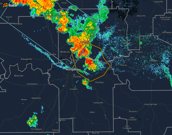
* Severe Thunderstorm Warning for…
South central Elmore County in east central Alabama…
Northeastern Montgomery County in south central Alabama…
* Until 715 PM CDT.
* At 624 PM CDT, a severe thunderstorm was located over Eastdale
Mall, or 7 miles northeast of Montgomery, and is nearly stationary.
HAZARD…60 mph wind gusts and quarter size hail.
SOURCE…Radar indicated.
IMPACT…Hail damage to vehicles is expected. Expect wind damage
to roofs, siding, and trees.
* Locations impacted include…
Montgomery, Wetumpka, Montgomery Zoo, Boylston, Auburn University
In Montgomery, Bob Woodruff Lake, Emerald Mountain, Mount Meigs,
Eastdale Mall, Blue Ridge, Waugh, Lagoon Park, Gunter Air Force
Base, Mitylene, Brassell and Tallapoosa Water Plant.
PRECAUTIONARY/PREPAREDNESS ACTIONS…
For your protection move to an interior room on the lowest floor of a
building.
Category: Alabama's Weather, ALL POSTS, Severe Weather
About the Author (Author Profile)
Scott Martin is an operational meteorologist, professional graphic artist, musician, husband, and father. Not only is Scott a member of the National Weather Association, but he is also the Central Alabama Chapter of the NWA president. Scott is also the co-founder of Racecast Weather, which provides forecasts for many racing series across the USA. He also supplies forecasts for the BassMaster Elite Series events including the BassMaster Classic.Subscribe
If you enjoyed this article, subscribe to receive more just like it.


