

Wet At Times Through Tomorrow; Lower Heat Levels Next Week
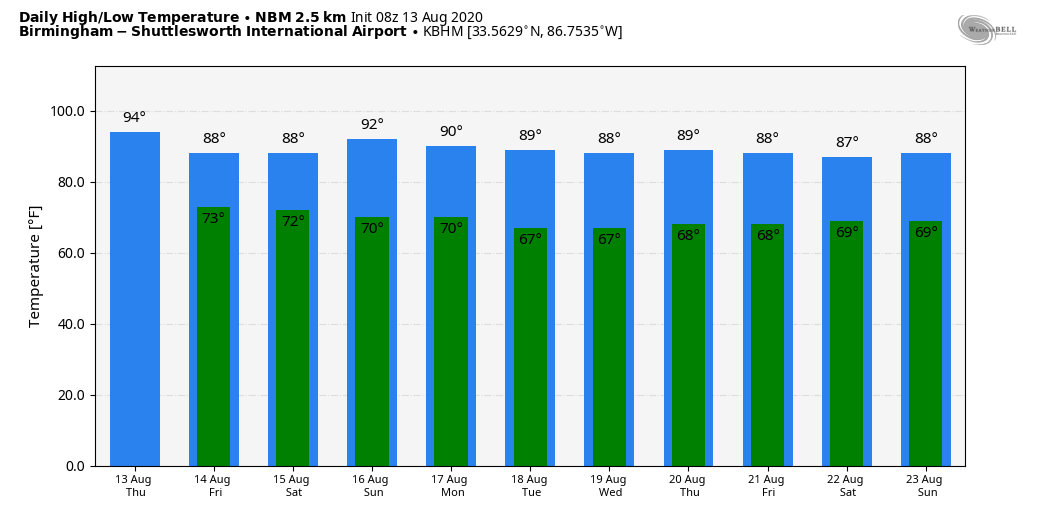
UNSETTLED SUMMER WEATHER: We note a few showers over Northeast Alabama early this morning, but most of the state is dry and very humid. Like recent days, we expect scattered to numerous showers and thunderstorms later today and tonight in the unstable air. Some spots will see heavy rain, gusty winds, and lots of lightning where stronger thunderstorms develop, and the high this afternoon will be in the 87-90 degree range for most communities. The average high for August 13 at Birmingham is 91.
Not much change tomorrow; the sky will feature more clouds than sun with a few passing showers or thunderstorms likely… the high will be in the mid to upper 80s with only a limited amount of sun.
THE ALABAMA WEEKEND: Showers should be fewer in number Saturday as the air will be drier, and by Sunday we expect only isolated showers with a good supply of sunshine. Highs over the weekend will be mostly in the 88-92 degree range.
NEXT WEEK: An upper trough will form over the eastern half of the nation, and it should bring some pretty pleasant weather around here for August. Highs mostly in the 80s, lows mostly in the 60s, and very few showers through the week. See the Weather Xtreme video for maps, graphics, and more details.
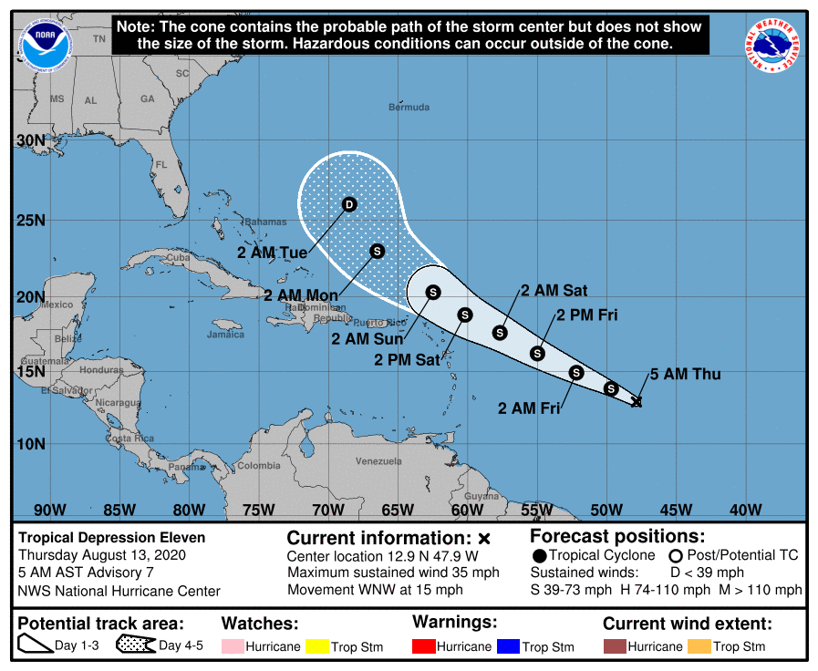
TROPICS: Tropical Depression 11 is still forecast to become a tropical storm today; the name will be Josephine. The system is in the Atlantic, about 1000 miles east of the northern Leeward Islands. It will gain latitude, and pass north of the Leeward Islands this weekend. Strong shear is expected to bring weakening in 3 days or so, and there is a pretty good chance it dissipates well east of the Bahamas. If by chance it survives, it will recurve into the open Atlantic well east of the U.S. The rest of the Atlantic basin, including the Gulf of Mexico, is quiet.
ON THIS DATE IN 2004: Charley made landfall as a category four hurricane on Captiva Island, Florida, around midday and it unleashed tremendous fury on the town of Punta Gorda about an hour later. After that, Charley tracked northeastward, toward Orlando. The hurricane hit Orlando as a Category 1 hurricane after midnight with maximum sustained winds of 85 mph. A couple of hours later, Charley passed near Daytona Beach and moved out into the Atlantic. Charley was initially expected to hit further north in Tampa, and caught many Floridians off-guard due to a sudden change in the storm’s track as it approached the state. Along its path, Charley caused 10 deaths and $16.9 billion in damage to insured residential property, making it the second costliest hurricane in United States history at the time. Charley was a compact, fast-moving storm, which limited the scope and severity of the damage.
BEACH FORECAST: Click here to see the AlabamaWx Beach Forecast Center page.
WEATHER BRAINS: Don’t forget you can listen to our weekly 90 minute show anytime on your favorite podcast app. This is the show all about weather featuring many familiar voices, including our meteorologists here at ABC 33/40.
CONNECT: You can find me on all of the major social networks…
Facebook
Twitter
Instagram
Pinterest
Snapchat: spannwx
Look for the next Weather Xtreme video here by 4:00 this afternoon… enjoy the day!
Category: Alabama's Weather, ALL POSTS, Weather Xtreme Videos
About the Author (Author Profile)
James Spann is one of the most recognized and trusted television meteorologists in the industry. He holds the AMS CCM designation and television seals from the AMS and NWA. He is a past winner of the Broadcast Meteorologist of the Year from both professional organizations.Subscribe
If you enjoyed this article, subscribe to receive more just like it.


