

Josephine Currently Struggling with Wind Shear; Slight Strengthening May Occur Tonight
SUMMARY OF 500 PM AST…2100 UTC…INFORMATION
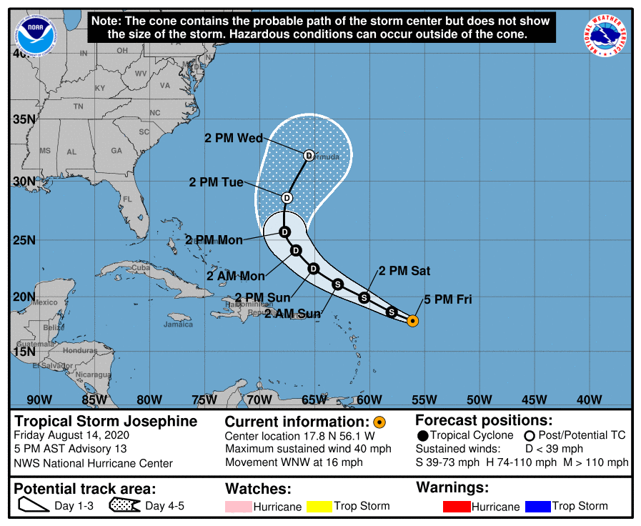
LOCATION…17.8N 56.1W
ABOUT 460 MI…740 KM E OF THE NORTHERN LEEWARD ISLANDS
MAXIMUM SUSTAINED WINDS…40 MPH…65 KM/H
PRESENT MOVEMENT…WNW OR 300 DEGREES AT 16 MPH…26 KM/H
MINIMUM CENTRAL PRESSURE…1004 MB…29.65 INCHES
WATCHES AND WARNINGS
There are no coastal watches or warnings in effect.
DISCUSSION AND OUTLOOK
At 500 PM AST (2100 UTC), the center of Tropical Storm Josephine was located near latitude 17.8 North, longitude 56.1 West. Josephine is moving toward the west-northwest near 16 mph (26 km/h), and this general motion is expected to continue for the next couple of days followed by a turn toward the northwest late this weekend or early next week. On the forecast track, the center of Josephine is expected to pass to the northeast of the Leeward Islands over the weekend.
Reports from an Air Force Reserve Hurricane Hunter aircraft indicate that maximum sustained winds are near 40 mph (65 km/h) with higher gusts. Slight strengthening is possible tonight. After that, Josephine is expected to weaken over the weekend as it encounters unfavorable upper-level winds.
Tropical-storm-force winds extend outward up to 80 miles (130 km) mainly to the north of the center.
The estimated minimum central pressure reported by the Hurricane Hunter aircraft is 1004 MB (29.65 inches).
HAZARDS AFFECTING LAND
RAINFALL: Josephine is expected to cause storm-total rainfall of 1 to 3 inches over portions of the northern Leeward Islands, The Virgin Islands, and Puerto Rico. Isolated minor flooding is possible in Puerto Rico through Monday.
About the Author (Author Profile)
Scott Martin is an operational meteorologist, professional graphic artist, musician, husband, and father. Not only is Scott a member of the National Weather Association, but he is also the Central Alabama Chapter of the NWA president. Scott is also the co-founder of Racecast Weather, which provides forecasts for many racing series across the USA. He also supplies forecasts for the BassMaster Elite Series events including the BassMaster Classic.Subscribe
If you enjoyed this article, subscribe to receive more just like it.


