

Saturday’s Weather Xtreme Video: Rain Chances Drop for a Little While; Tropics Remain Active
BUSY IN THE TROPICS, NO THREATS TO THE USA
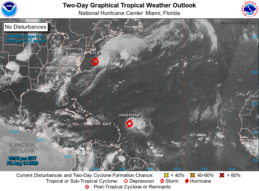
As of the 10:00 pm Friday night update from the National Hurricane Center, we have two tropical storms over the Atlantic… Josephine and Kyle.
The center of Josephine was located around 375 miles to the east of the Northern Leeward Islands with a minimum pressure of 1005 MB. Maximum sustained winds were at 45 MPH and the movement was to the west-northwest at 16 MPH. This general motion is expected to continue for the next couple of days followed by a turn toward the northwest late this weekend or early next week, keeping northeast of the Leeward Islands over the weekend. Josephine is expected to weaken as it encounters unfavorable upper-level winds and may be a depression by Sunday morning or earlier.
The center of Kyle was located 250 miles east-southeast of Atlantic City, New Jersey with a minimum pressure of 1006 MB. Maximum sustained winds were at 45 MPH and movement was to the east-northeast at 16 MPH. A slightly faster east-northeastward or eastward movement is expected during the next few days. Some additional strengthening is possible during the next day or so, then Kyle is forecast to become post-tropical by Sunday night.
The rest of the Atlantic Basin is free from any tropical activity as of now.
RAIN CHANCES BEGIN TO DROP FOR THE WEEKEND
A near typical summertime day for your Saturday with skies ranging from mostly clear to partly cloudy. Scattered showers and thunderstorms will once again be possible across all of Central Alabama mainly during the afternoon and into the early evening hours, with rain chances maxing out around 20%-60% from northwest to southeast. Afternoon highs will be in the upper 80s to the lower 90s.
Sunday looks to be a much drier day across Central Alabama as we’ll have a day to dry out. I can’t completely rule out a stray shower in the extreme northwestern parts of the area, but rain chances will be highly unlikely. Skies will be mostly sunny to partly cloudy across the area and highs will top out in the lower to mid-90s.
COOLER WITH LOW RAIN CHANCES TO START THE WORKWEEK
Monday will be an overall nice day with mostly sunny skies, but we are not getting much cooling help from Mother Nature. An isolated shower may be possible for locations along and south of the I-85 and US-80 corridors during the afternoon while the rest of the area looks to be dry. Highs will be in the upper 80s to the mid-90s across the area from northwest to southeast.
A little higher rain chances move in for Tuesday as there will be a chance of isolated to scattered showers and storms during the afternoon hours mainly south of the I-59 corridor. While rain chances are not zero north of that, a shower looks to be highly unlikely at this point. Highs will be a little cooler, reaching the upper 80s to the lower 90s.
THE WORKWEEK ENDS WITH INCREASED RAIN CHANCES
Scattered to numerous afternoon and evening showers and thunderstorms will be likely across Central Alabama on Wednesday with increasing rain chances from northwest to southeast. The European model shows this solution while the latest GFS shows a much drier day. I’ll side with the European on this package. Afternoon highs will be in the mid-80s to right at 90 degrees across the area from north to south.
Thursday and Friday look to be rather similar in the forecast as a few showers and storms may be possible during the morning hours with activity increasing with daytime heating. Showers and storms will be likely along and south of I-59 while a good chance can be expected north of that. Highs on Thursday will be in the mid to upper 80s and reaching the upper 80s to the lower 90s on Friday.
ON THIS DATE IN WEATHER HISTORY
1787 – Tornadoes were reported in Connecticut, Rhode Island, Massachusetts, and New Hampshire. Wethersfield CT was hard hit by the tornado outbreak.
1939 – The remnants of Hurricane Two were slowly crawling across Alabama as it was heading northward and eventually dissipating over New York on the 20th. Torrential rain fell in Alabama as a result of the storm’s slow forward movement, leading to severe flooding.
BEACH FORECAST CENTER
Get the latest weather and rip current forecasts for the beaches from Dauphin Island, AL, to Panama City Beach, FL, on our Beach Forecast Center page. There, you can select the forecast of the region that you are interested in.
ADVERTISE ON THE BLOG!
We had another fantastic year in 2019 with just over 17 million page views! That brings our total for the last 2 years close to 37 million page views! Don’t miss out! We can customize a creative, flexible, and affordable package that will suit your organization’s needs. Contact Bill Murray at (205) 687-0782.
E-FORECAST
Get the Alabama Wx Weather Blog’s Seven-Day Forecast delivered directly to your inbox by email twice daily. It is the most detailed weather forecast available in Central Alabama. Subscribe here… It’s free!
CONNECT WITH THE BLOG ON SOCIAL MEDIA
You can find the AlabamaWx Weather Blog on the major social media networks:
Facebook
Twitter
Instagram
WEATHERBRAINS
There are several ways to watch or listen to the podcast that is all about the weather. Watch live starting at 8:00 pm CT on Monday nights at live.bigbrainsmedia.com, James Spann’s Youtube Channel, or on one of ABC 3340’s digital weather channels (17.2, 40.2, 68.3). Listen to the recorded audio podcast at WeatherBrains.com or on your favorite podcast platform (Apple Podcasts, Stitcher, Spotify, etc.), or watch the recorded video on James Spann’s Youtube channel.
Category: Alabama's Weather, ALL POSTS, Tropical, Weather Xtreme Videos
About the Author (Author Profile)
Scott Martin is an operational meteorologist, professional graphic artist, musician, husband, and father. Not only is Scott a member of the National Weather Association, but he is also the Central Alabama Chapter of the NWA president. Scott is also the co-founder of Racecast Weather, which provides forecasts for many racing series across the USA. He also supplies forecasts for the BassMaster Elite Series events including the BassMaster Classic.Subscribe
If you enjoyed this article, subscribe to receive more just like it.


