

Mostly Dry Today; Rain Chances Increase Over The Latter Half Of The Week
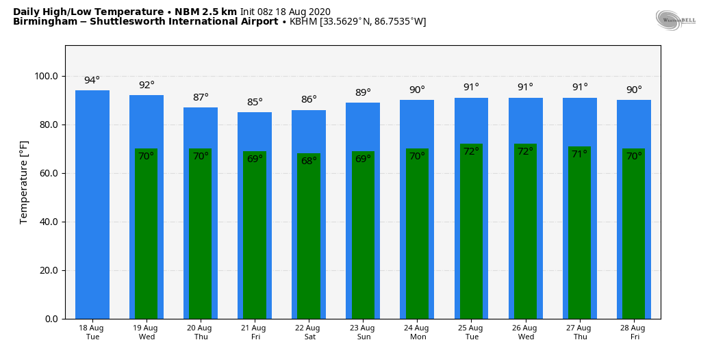
TOUCH OF FALL: Temperatures have dropped into the 60-65 degree range across much of North Alabama early this morning for a nice taste of fall. The air is very dry over the northern half of the state, meaning little risk of a shower today, and lower humidity values. The high will be in the low 90s for most communities this afternoon; the average high for Birmingham on August 18 is 91.
REST OF THE WEEK: Moisture levels rise, and we will bring back the chance of scattered, mostly afternoon and evening showers and thunderstorms tomorrow with a high in the upper 80s. Then, look for scattered to numerous showers and thunderstorms Thursday and Friday with highs dropping into the mid 80s. Most places will see 1/2 to 1 inch of rain tomorrow through Friday.
THE ALABAMA WEEKEND: Showers should become fewer in number Saturday as the air becomes drier, and Sunday looks pretty quiet with only isolated showers. The high Saturday will be in the upper 80s, and close to 90 Sunday.
NEXT WEEK: For now we will go with a summer persistence forecast, but the weather around here will all depend on how the tropical systems to the south behave. It is simply too early to know what, if any impact we will see here. See the Weather Xtreme video for maps, graphics, and more details.
TROPICS: NHC is monitoring two distinct tropical waves in the Atlantic basin; both will likely become a tropical storm by the end of the week. The names will be “Laura” and “Marco”.
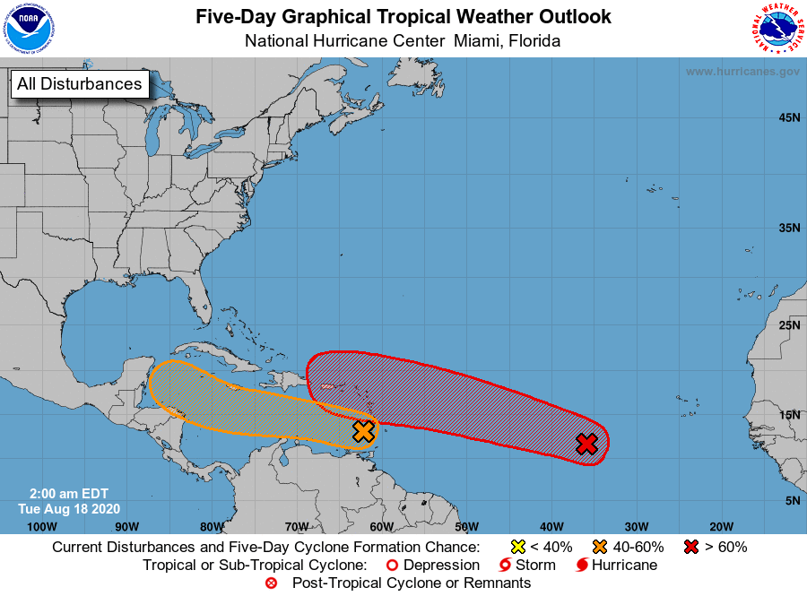
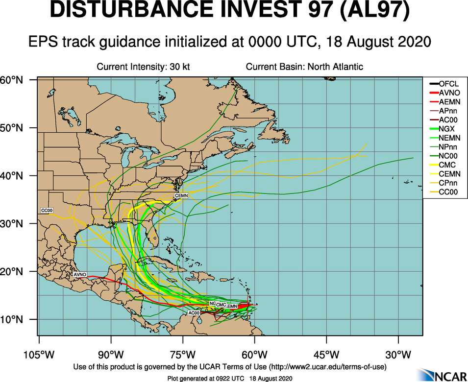
INVEST 97L: The lead wave is now over the eastern Caribbean. This disturbance is moving westward at about 20 mph, and is forecast to continue to move quickly westward over the eastern and central Caribbean Sea during the next couple of days, which is likely to limit significant development. After that time, however, the system is forecast to move more slowly westward across the western Caribbean, where upper-level winds could become more conducive for the development of a tropical depression during the latter part of this week. Regardless of development, locally heavy rainfall and gusty winds are expected over portions of the Windward and southern Leeward Islands this morning.
In the longer range, there is a decent chance this system reaches the Gulf of Mexico, but there is no way to know the final destination or intensity. Just something to watch for now.
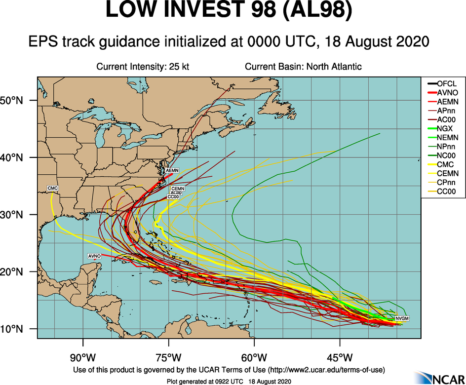
INVEST 98L: The eastern-most wave, now a little over 700 miles west-southwest of the Cabo Verde Islands is producing a concentrated area of showers and thunderstorms displaced to the west of an elongated surface circulation. Environmental conditions are conducive for further development, and a tropical depression is likely to form within the next day or two while the system moves westward to west-northwestward at 15 to 20 mph across the central and western portions of the tropical Atlantic. Again, it is way too early to now the ultimate track and intensity.
If you have a beach trip planned next week, there is no need to cancel. Just keep an eye on updates, and we will have much better clarity late this week on the potential of both systems.
ON THIE DATE IN 1983: Alicia became a major hurricane and made landfall an hour later on Galveston Island with maximum sustained winds of 100 mph and a minimum barometric pressure of 962 mb (28.41″) as measured by aircraft reconnaissance, making it a low end Category 3 on the Saffir–Simpson hurricane scale. Alicia was the first hurricane to strike the continental United States since Hurricane Allen moved ashore South Texas in August 1980, ending the longest break in contiguous U.S. hurricane landfalls of the 20th century. The hurricane was also the first major hurricane to impact the Greater Houston area since Hurricane Carla in 1961.
Widespread damage was wrought in Galveston and Houston, where thousands of homes were destroyed. In Downtown Houston, nearly all skyscrapers saw the loss of approximately half of lower-level windows, littering the urban streets with debris. Widespread power outages and flooding impacted much of Southeast Texas, with observed rainfall totals peaking just under 10 inches. In addition to the strong winds, rough surf, and heavy rain, Alicia also generated 22 tornadoes centered around the Houston–Galveston area; most were rated F0, but the strongest, an F2, tore through Corsicana farther north.
BEACH FORECAST: Click here to see the AlabamaWx Beach Forecast Center page.
WEATHER BRAINS: Don’t forget you can listen to our weekly 90 minute show anytime on your favorite podcast app. This is the show all about weather featuring many familiar voices, including our meteorologists here at ABC 33/40.
CONNECT: You can find me on all of the major social networks…
Facebook
Twitter
Instagram
Pinterest
Snapchat: spannwx
Look for the next Weather Xtreme video here by 4:00 this afternoon… enjoy the day!
Category: Alabama's Weather, ALL POSTS, Weather Xtreme Videos
About the Author (Author Profile)
James Spann is one of the most recognized and trusted television meteorologists in the industry. He holds the AMS CCM designation and television seals from the AMS and NWA. He is a past winner of the Broadcast Meteorologist of the Year from both professional organizations.Subscribe
If you enjoyed this article, subscribe to receive more just like it.


