

Heavy Tropical Rains Continue for The Dominican Republic from Tropical Storm Laura
NHC UPDATE SUMMARY OF 10:00 PM CDT INFORMATION
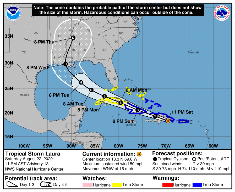
LOCATION…18.3N 69.6W
ABOUT 25 MI…40 KM SE OF SANTO DOMINGO DOMINICAN REPUBLIC
MAXIMUM SUSTAINED WINDS…50 MPH…85 KM/H
PRESENT MOVEMENT…WNW OR 285 DEGREES AT 16 MPH…26 KM/H
MINIMUM CENTRAL PRESSURE…1003 MB…29.62 INCHES
WATCHES AND WARNINGS
A Tropical Storm Warning is in effect for…
* Puerto Rico, Vieques, and Culebra
* The northern coast of the Dominican Republic from Cabo Engano to the border with Haiti
* The southern coast of the Dominican Republic from Cabo Engano to Punta Palenque
* The northern coast of Haiti from Le Mole St. Nicholas to the border with the Dominican Republic
* The southeastern Bahamas and the Turks and Caicos Islands
* Cuban provinces of Camaguey, Las Tunas, Holguin, Guantanamo, Santiago de Cuba, and Granma
A Tropical Storm Watch is in effect for…
* The central Bahamas
* Andros Island
* The Florida Keys from Ocean Reef to Key West and the Dry Tortugas
* Florida Bay
* Cuban provinces of Ciego De Avila, Sancti Spiritus, Villa Clara, Cienfuegos, Matanzas, Mayabeque, La Habana, Artemisa, and Pinar Del Rio
DISCUSSION AND OUTLOOK
At 1100 PM AST (0300 UTC), the center of Tropical Storm Laura was located near latitude 18.3 North, longitude 69.6 West. Laura is moving toward the west-northwest near 16 mph (26 km/h) and this general motion is expected over the next few days. On the forecast track, the center of Laura will move across Hispaniola tonight and early Sunday, near or over Cuba Sunday and Monday, and over the southeastern Gulf of Mexico Monday night and Tuesday.
Maximum sustained winds are near 50 mph (85 km/h) with higher gusts. No significant changes in strength are forecast during the next 36 to 48 hours while Laura moves near or over Hispaniola and Cuba. Strengthening is forecast once Laura moves into the Gulf of Mexico Monday night and Tuesday.
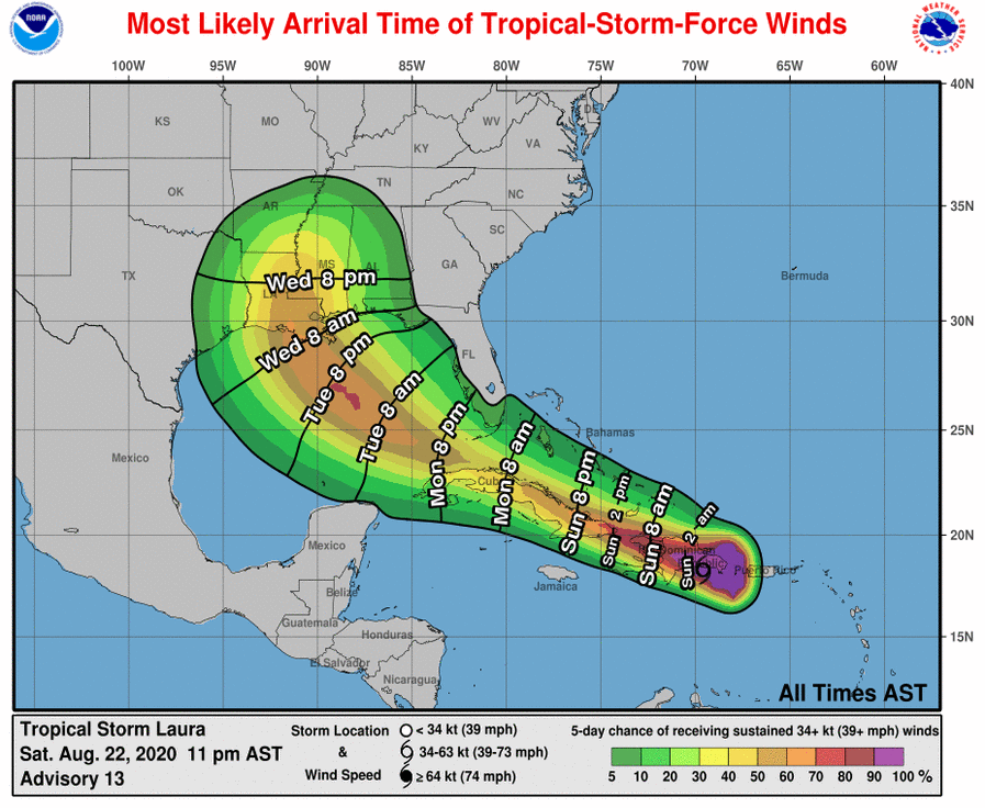
Tropical-storm-force winds extend outward up to 140 miles (220 km) from the center.
The estimated minimum central pressure is 1003 MB (29.62 inches).
HAZARDS AFFECTING LAND
RAINFALL: Laura is expected to produce the following rainfall accumulations through Tuesday:
Western Puerto Rico: An additional 1 to 2 inches of rainfall, with maximum storm total accumulations of 8 inches, is possible before the rain diminishes overnight.
Dominican Republic and Haiti: 4 to 8 inches, with maximum amounts of 12 inches across southern areas.
Cuba: 3 to 6 inches, with isolated amounts of 8 inches.
This heavy rainfall could lead to life-threatening flash and urban flooding, and the potential for mudslides across the Greater Antilles. Widespread minor to potentially moderate river flooding is possible in Puerto Rico.
Rainfall amounts of 1 to 3 inches, with isolated maximum totals of 5 inches, is expected over the Turks and Caicos, southeast Bahamas, and Jamaica.
WIND: Tropical storm conditions are expected within portions of the warning area through Sunday night. Tropical storm conditions are possible within portions of the watch area on Monday.
SURF: Swells generated by Laura are affecting portions of the Virgin Islands, Puerto Rico, and Hispaniola. These swells are expected to spread across Cuba, much of the Bahamas, and the Florida Keys during the next few days. Please consult products from your local weather office.
Category: Alabama's Weather, ALL POSTS, Severe Weather, Tropical
About the Author (Author Profile)
Scott Martin is an operational meteorologist, professional graphic artist, musician, husband, and father. Not only is Scott a member of the National Weather Association, but he is also the Central Alabama Chapter of the NWA president. Scott is also the co-founder of Racecast Weather, which provides forecasts for many racing series across the USA. He also supplies forecasts for the BassMaster Elite Series events including the BassMaster Classic.Subscribe
If you enjoyed this article, subscribe to receive more just like it.


