

Stronger Cells May Produce Localized Flooding Issues over Extreme Southeastern Parts of Central Alabama Tonight
SUMMARY…Flash flooding becoming much less likely through the overnight hours with the waning of deeper vertical convection. Lingering ongoing stronger cells may produce isolated/localized flooding in the very near term.
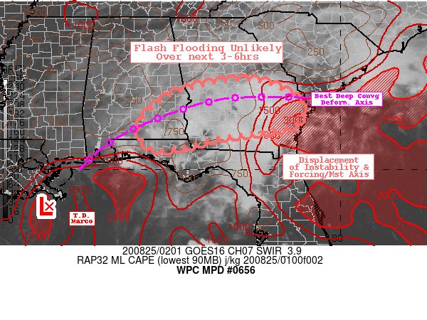
DISCUSSION…Vertical shear and reduction of surface based instability is starting to play a negative role in maintaining convection across the discussion area. GOES-WV suite denotes the remaining more concentric mid-level vorticity center continues to stretch and elongate across SE AL into W GA into the deeper large scale trough from the Central Gulf through the Carolinas, this along with continued favorable right entrance jet ascent is maintaining a cluster of convection across South-Central GA. But the RADAR, lightning denotes a downward trend with increased outflow nature to the echos as they begin to tilt over in the increased vertical shear with lessened instability. This will increase the rainfall footprint and reduce the intensity over the next hour or so. Given this is also falling across unsaturated soils over the last day into few weeks, exceeding the normal generally higher FFG values of the region suggests flash flooding is unlikely over the early to mid-overnight hours except in very localized or urban settings that are highly prone to flooding.
RAP analysis and 00z RAOBs suggest that moist is quite deep and values are ranging from 2.25-2.5″ in the shear axis, but instability has diminished back to the warmer Gulf/Atlantic sources. The still strong southerly low level warm advective regime will continue through the night across the Coastal Plain of North Florida, but forcing should remain disorganized until perhaps well into the late overnight hours (07-09z) when better diurnal tidal forcing starts up again… and this will need to be monitored closely for thunderstorm and therefore efficient/deep vertical convection posing a flash flood risk toward that time; so in coordination with the Excessive Rainfall Outlook forecaster, the Slight Risk will remain in place on this potential across S AL/S GA.
Also of note: the greatest potential for flash flooding over the next 5-6 hours will reside over S AL and far W FL panhandle where cells have a potential for greater vertical depth, moisture, and proximity to conditionally unstable air mass off the Gulf… trends will be monitored closely for any future MPD in the next 6 hours.
Category: ALL POSTS
About the Author (Author Profile)
Scott Martin is an operational meteorologist, professional graphic artist, musician, husband, and father. Not only is Scott a member of the National Weather Association, but he is also the Central Alabama Chapter of the NWA president. Scott is also the co-founder of Racecast Weather, which provides forecasts for many racing series across the USA. He also supplies forecasts for the BassMaster Elite Series events including the BassMaster Classic.Subscribe
If you enjoyed this article, subscribe to receive more just like it.


