

Notes at Nine on Laura

As we expected, Hurricane Laura has strengthened quickly over the last 24 hours. In fact, it has met the NHC definition of rapid deepening, which is a 30 knot (35 mph) increase) in wind in 24 hours. Yesterday at 7 a.m. (12z) the winds were 65 knots, and this morning at 7, they were 100 knots (115 mph).
In terms of pressure, at 7 a.m. yesterday, the pressure was 990 millibars and it was still there at 1 p.m. as well. The Air Force plane found 960 millibars at 7:25 a.m. this morning. The NOAA crew just measured 959 millibars. The eye was closed with a diameter of 25 nautical miles. Flight levels winds were 126 mph. The surface wind was estimated at 120 mph.
Flight level winds have been measured at 140 mph with SFMR measurements of surface winds of 120 mph. So Laura will be even stronger on the 10 a.m. advisory which we will have within the hour.
The hurricane will encounter increasing shear and may undergo an eyewall replacement later today, which will weaken it slightly, but it still will be a major hurricane at landfall, and destruction from surge and wind will be immense in southwestern Louisiana and across the border in Texas. Places like Johnson Bayou, Cameron, Creole, Grand Chenier, and Holly Beach will experience devastation. Surge will be driven inland nearly 40 miles and water will be several feet deep in Lake Charles, which is well inland.
There will be tremendous power outages across extreme eastern Texas nad a large par oof Louisiana, which is heavily forested.
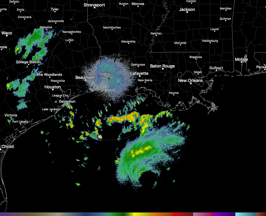
The eye of Hurricane Laura is now visible from coastal radars. Here is the Lake Charles radar.
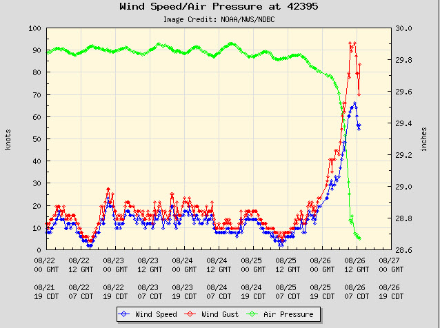
NOAA Buoy 42395 has been in the eyewall. Winds have gusted to 107 mph with a sustained wind of 74 mph.
Some coastal observations at 9 a.m.
Calcasieu Pass (near Cameron)…ENE 14G22
Port Fourchon LA (south of New Oreans)…NE winds 21 mph gusting to 37 mph.
South Marsh (50 miles SW of Mogan City)…east winds at 49 mph.
Lake Charles…PtSunny…80F/79F…ENE 15/G22…29.86 Steady
Beaumont…PtSunny…82F/78F…NE17G25…29.84 Steady
Galveston…Light Rain…82F/79F…NE 18…29.83 Rising
Tides between the Texas line and Intracoastal City in Vermillion Parish are now expected to rise to ass much as 18-20 feet above normal. For comparison purposes, Rita in 2005 brought an 18 foot surge to the coast in this same area. Nearly all structures in southern Cameron Parsissh were destroyed in Rita.
About the Author (Author Profile)
Bill Murray is the President of The Weather Factory. He is the site's official weather historian and a weekend forecaster. He also anchors the site's severe weather coverage. Bill Murray is the proud holder of National Weather Association Digital Seal #0001 @wxhistorianSubscribe
If you enjoyed this article, subscribe to receive more just like it.


