

Midday Update: Laura Weakening, Storms Developing
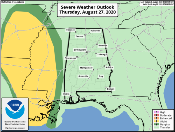
HOT & HUMID THURSDAY: A very tropical air mass remains in place across the state, allowing for a partly sunny sky, and we are watching the radar as scattered showers and thunderstorms are developing and will continue to do so the rest of today and tonight. Temperatures this afternoon are in the lower 90s, and again heat index values are over 100° in some spots. We are watching Laura moving north, west of Alabama today, good news for us is that the direct wind and rain associated with the system will remain well to the west of the state. We also, note, the main area of severe weather and tornadoes is just west of Alabama and across Mississippi, Arkansas, and Louisiana, however some strong storms are possible across Alabama this afternoon and evening.
FOR OUR FRIDAY: As the circulation of Laura turns eastward north of Alabama, our rain chances will be on the increase and we will have the threat for some tornadoes over the northern third of the state, where high shear and veering winds will be present. With any tropical system moving inland some rotating showers or thunderstorms are expected during the day.
The SPC has a “slight risk” (level 2/5) defined for areas as far south as Scottsboro, Hanceville, and Reform, and there is a “marginal risk” (level 1/5) as far south as Demopolis to Columbiana to Heflin.
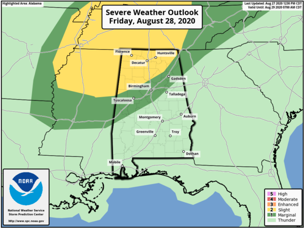
In these areas some isolated tornadoes will be possible tomorrow, especially during the afternoon and evening hours during the peak of the daytime heating process. Typically tornadoes associated with tropical systems are short lived, and can be hard to warn for since the storms typically are low topped and sometimes can literally be “under the radar”. Just be weather aware tomorrow and put yourself in a position to hear warnings in the event they are needed. Otherwise, the sky will be mostly cloudy with a good chance of occasional showers and a few thunderstorms. The high tomorrow will be in the mid 80s.
LATEST ON LAURA: Hurricane Laura made landfall overnight at Cameron, Louisiana as a high-end category 4 hurricane with winds of 150 mph. The storm is moving north rapidly and weakening, but continues to pose a threat to life and property, and has left a path of destruction across Louisiana as it moved north.
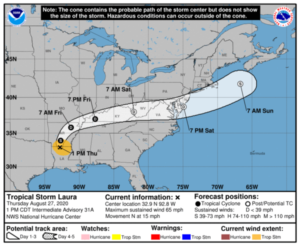
As of 1PM, Laura has been downgraded to a tropical storm as it is moving across Northern Louisiana, heading towards Arkansas. At 100 PM CDT, the center of Tropical Storm Laura was located inland over northern Louisiana near latitude 32.9 North, longitude 92.8 West. Laura is moving toward the north near 15 mph and this motion should continue through this afternoon. A northeastward to east-northeastward motion is expected tonight and Friday. On the forecast track, the center of Laura is forecast to move over Arkansas tonight, the mid-Mississippi Valley on Friday, and the mid-Atlantic states on Saturday.
Maximum sustained winds have decreased to near 65 mph with higher gusts. Continued weakening is forecast, and Laura is expected to weaken to a tropical depression this evening or overnight. Tropical-storm-force winds extend outward up to 105 miles from the center. A sustained wind of 44 mph and a gust to 62 mph was recently reported at Monroe Regional Airport in Louisiana. A wind gust to 52 mph was recently reported at South Arkansas Regional Airport. The estimated minimum central pressure based on surface observations is 988 mb (29.18 inches).
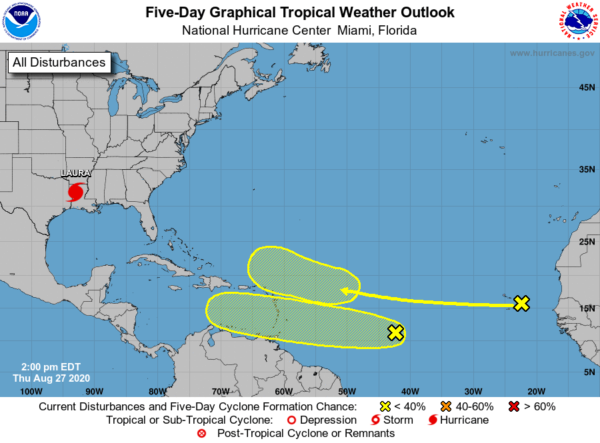
Elsewhere in the tropics, the Atlantic Basin is quiet for now, but the NHC is watching two areas of concern.
1. A westward-moving tropical wave located over the far eastern tropical Atlantic near the Cabo Verde Islands continues to produce disorganized shower activity. Although environmental conditions are not expected to be conducive for development during the next couple of days, they are forecast to gradually become more favorable over the weekend and into early next week when the wave moves into the central and then western tropical Atlantic. Formation chance through 5 days…low…20 percent.
2. Shower and thunderstorm activity has increased today in association with a tropical wave over the central tropical Atlantic. Gradual development of this system is possible over the next several days as it moves westward at 15 to 20 mph. Formation chance through 5 days…low…30 percent.
WET AT TIMES THIS WEEKEND: For Saturday and Sunday, Laura will leave a very moist, tropical air mass over Alabama. The sky will feature more clouds than sun both days with occasional showers and storms. Not “wash-out” but the pattern will be pretty wet at times as the radar will be active with areas of rain and storms, with the highest coverage during the afternoon and evening hours. Highs over the weekend due to the clouds and rain will be in the mid to upper 80s. We note, a few strong storms are still Saturday afternoon over the northern third of the state, where SPC has defined a “marginal risk” (level 1/5).
NEXT WEEK: A lingering moisture-rich air mass, means scattered to numerous showers and storms are expected on a daily basis with the greatest coverage coming from roughly noon to midnight. When it is not raining, expect a mix of sun and clouds with highs generally in the upper 80s.
Category: Alabama's Weather, ALL POSTS
About the Author (Author Profile)
Macon, Georgia Television Chief Meteorologist, Birmingham native, and long time Contributor on AlabamaWX. Stormchaser. I did not choose Weather, it chose Me. College Football Fanatic. @Ryan_StinnetSubscribe
If you enjoyed this article, subscribe to receive more just like it.


