

Scattered Storms Through the Weekend and Into the Start of the Workweek
WET AT TIMES THROUGH THE WEEKEND
We’ll have more waves of showers and storms move through the area today, most of which will be from the moisture fetch of Laura. The good news is that moisture levels will drop throughout the day as dry air will be advected into Central Alabama, therefore rainfall amounts will not be as high. However, showers and storms will be likely, especially by the afternoon and early evening hours. Highs will be in the upper 80s to the lower 90s.
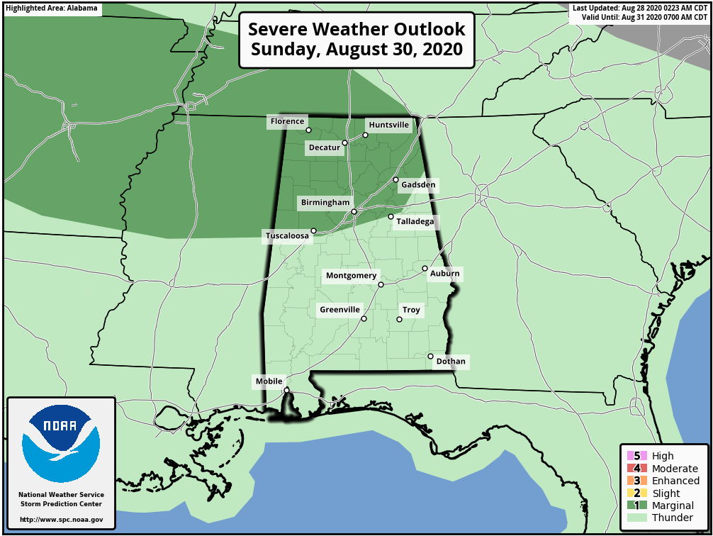
The effects of Laura will be long gone on Sunday and we could possibly see some subsidence form over much of the area behind Laura. While models have shown showers and storms becoming likely, we’ll reduce that a little bit and say there will be a decent chance of scattered mainly afternoon showers and storms. A couple of storms may become strong to marginally severe with the possibility of isolated damaging wind gusts. Highs will be in the upper 80s to the lower 90s.
THE WORKWEEK: STORMS TO START, MAINLY DRY TO END
Unfortunately, moisture returns on Monday as a trough will be digging in to our west, allowing moisture-rich air to flow in from the southwest. Showers and thunderstorms will be likely mainly in the afternoon and early evening hours. Highs will be in the mid-80s to the lower 90s.
Much of the same story for Tuesday as showers and storms will be likely mainly during the afternoon and early evening hours, but coverage of those should be a little less. Highs will be in the mid-80s to the lower 90s.
Subsidence sets back in across the area on Wednesday and Thursday as high pressure builds over the southeast just to our east-northeast. There will be plenty of sunshine on both days but we may have an isolated shower or storm during the afternoon hours. Highs on both days will be in the upper 80s to the lower 90s.
We’ll have a slight rise in the chance of scattered afternoon showers and storms on Friday, but the good news is that most locations will stay dry. Highs will be in the mid-80s to the lower 90s.

THE TROPICS
At 12:30 am: A tropical wave located about 600 miles east of the Windward Islands is producing disorganized showers and thunderstorms. Some gradual development of this system is possible during the next several days while it moves westward at about 15 mph toward the Lesser Antilles. Regardless of development, this system will likely produce gusty winds and locally heavy rainfall across portions of the Windward and Leeward Islands on Sunday.
The formation chance through the next five days is low at 30 percent.
Another tropical wave is located over the eastern Atlantic Ocean just southwest of the Cabo Verde Islands. This system is expected to move very slowly for the next several days, and some development is possible early next week over the eastern or central tropical Atlantic. The formation chance through the next five days is medium at 40 percent.
The rest of the Atlantic Basin is quiet.
ON THIS DATE IN WEATHER HISTORY
2005 – Hurricane Katrina made landfall in Plaquemines Parish in southeastern Louisiana early on the 29th with maximum sustained winds near 125 mph, a strong category-three, and the third most-intense landfalling hurricane in U.S. history. The center of the hurricane passed just east of New Orleans, where winds gusted over 100 mph. Widespread devastation and unprecedented flooding occurred, submerging at least 80 percent of the city as levees failed. Farther east, powerful winds and a devastating storm surge of 20-30 feet raked the Mississippi coastline, including Gulfport and Biloxi, where Gulf of Mexico floodwaters spread several miles inland. Rainfall amounts of 8-10 inches were common along and to the east of the storm’s path. Katrina weakened to a tropical storm as it tracked northward through Mississippi and gradually lost its identity as it moved into the Tennessee Valley on the 30th.
BEACH FORECAST CENTER
Get the latest weather and rip current forecasts for the beaches from Dauphin Island, AL, to Panama City Beach, FL, on our Beach Forecast Center page. There, you can select the forecast of the region that you are interested in.
ADVERTISE ON THE BLOG!
We had another fantastic year in 2019 with just over 17 million page views! That brings our total for the last 2 years close to 37 million page views! Don’t miss out! We can customize a creative, flexible, and affordable package that will suit your organization’s needs. Contact Bill Murray at (205) 687-0782.
E-FORECAST
Get the Alabama Wx Weather Blog’s Seven-Day Forecast delivered directly to your inbox by email twice daily. It is the most detailed weather forecast available in Central Alabama. Subscribe here… It’s free!
CONNECT WITH THE BLOG ON SOCIAL MEDIA
You can find the AlabamaWx Weather Blog on the major social media networks:
Facebook
Twitter
Instagram
WEATHERBRAINS
There are several ways to watch or listen to the podcast that is all about the weather. Watch live starting at 8:00 pm CT on Monday nights at live.bigbrainsmedia.com, James Spann’s Youtube Channel, or on one of ABC 3340’s digital weather channels (17.2, 40.2, 68.3). Listen to the recorded audio podcast at WeatherBrains.com or on your favorite podcast platform (Apple Podcasts, Stitcher, Spotify, etc.), or watch the recorded video on James Spann’s Youtube channel.
Category: Alabama's Weather, ALL POSTS, Severe Weather, Tropical, Weather Xtreme Videos
About the Author (Author Profile)
Scott Martin is an operational meteorologist, professional graphic artist, musician, husband, and father. Not only is Scott a member of the National Weather Association, but he is also the Central Alabama Chapter of the NWA president. Scott is also the co-founder of Racecast Weather, which provides forecasts for many racing series across the USA. He also supplies forecasts for the BassMaster Elite Series events including the BassMaster Classic.Subscribe
If you enjoyed this article, subscribe to receive more just like it.


