

Sunday Weather Xtreme: Storms Through Tuesday, Drier by Midweek
August is drawing to a close on an active note across Alabama. After storms produced tornadoes on Friday, Saturday started off with scattered showers and storms as the long 850 mb jet stretching back from the remnants of Hurricane Laura over the Northeast dispatched some showers and storms across the Central part of the state during the morning. Clouds were slow to clear in many spots, and this led to some wide ranges in temperatures. At 1 p.m. it was only 78F in Birmingham, while t was 86F in Tuscaloosa and 86F at Muscle Shoals. The clouds thinned shortly thereafter in the Birmingham area, but it still was hard for the mercury to catch up. By 4 p.m., it was 90F in places like Tuscaloosa, Muscle Shoals, UAH, and Scottsboro, but still only 83 at the Shuttlesworth Birmingham International Airport. Only a few scattered storms managed to develop from Sumter over into Bibb Counties by mid-afternoon, and showers were scarcer than hen’s teeth elsewhere.
OUR ATTENTION TURNS…to the northwest and north now as frontal system lying along the Tennessee/Alabama border becomes the focus for our weather over the next few days. A few scattered showers and storms formed overnight over northwestern sections of the state in the vicinity of that boundary, but their main impact has been to settle a boundary down into Central Alabama. A few cells will form this morning across Central Alabama, along that boundary, but the main action will come this afternoon with the heating of the day gets up a full head of steam and see will likely see a good number of showers and storms form in the region just south of I-20. In addition, thunderstorm complexes may form along the frontal boundary and move eastward. All of this activity will have warm, moist, and unstable air to work with, and the result will be some isolated reports of damaging winds and possibly large hail, so the SPC has parts of North and Central Alabama outlooked for a risk of severe weather for today. Highs today will be generally in the upper 80s. We may deal with some shower and thunderstorm activity overnight, so keep that umbrella handy. Lows will be in the lower 70s.
MONDAY STORMS: Monday looks active with an approaching upper-level disturbance, the presence of the front to the north, and the warm, moist, and unstable airmass still in place. A few of the storms could be strong to severe Monday afternoon and evening, with damaging winds the main threat. We will keep an eye on things and you should too. Highs will be in the upper 80s again.
REST OF THE WEEK, DAY BY DAY: The best chances for rain and storms on Tuesday appear to be over the northern part of the state as some drier air works into the state. It looks like that drier air will be firmly in control of all of North and Central Alabama by Wednesday leading to mostly dry conditions. By Wednesday, that trough over the Northwest will dig down into Oklahoma and Texas. As it passes by to our north on Thursday and Friday, it will propel the frontal system through the area and send it on a Gulf Coast vacation for the weekend. This means Showers and thunderstorms for the Tennessee Valley on Thursday, but by Friday they will be focused across Central Alabama. Saturday and Sunday should be warm and dry for North and Central portions of the state as the rain chances will be limited to South Alabama. Temperature’s through Friday will be warm, with highs near 90F each day. Lows will be in the lower 70s. Weekend highs will drop back into the middle and upper 80s.
VOODOO TERRITORY: The longer-range forecast suggests a few showers and storms work back in here for Labor Day and that week is dominated by troughs and fronts that will mean more rain, and trending to slightly cooler across the area.
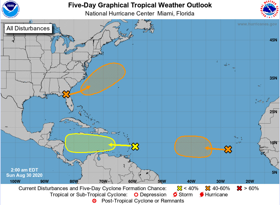
TROPICS: The NHS is tracking two tropical waves in the Atlantic. The first is moving through the Windward islands now and will track across the Caribbean and toward Central American this week. Only a low chance of development. The second, between the islands and the coast of Africa, has a better chance of formation. Neither of our main global models makes much of it, but the European does have something near the northern Leeward Islands around the 8th. Something to keep an eye on. They are also tracking a low that is expected to form off the southeastern coast of the U.S. that could become a depression this week. It isn’t a
GULF COAST WEATHER: Showers and thunderstorms will be fairly common in the week ahead along the beautiful beaches of Alabama and Northwest Florida. There won’t be much diurnal range in temperature, with highs in the middle 80s along the beaches, and lows in the upper 70s. Water temperatures are in the middle 80s. There is a high rip current risk today, and the risk will be moderate the remainder of the week.
FRIDAY’S TORNADOES: National Weather Service meteorologists confirmed at least three tornadoes across North Central Alabama on Friday as the remnants of Hurricane Laura passed by to our northwest and north. The first tornado cut a nearly nine-mile path through Winston County, forming 3 miles southeast of Ashbridge about 4:18 p.m. touched down just north of Double Springs in Winston County. Max winds are estimated to be 105 mph. A second tornado touched down 1 mile north northeast of Winston Free State Barn about 4:36 p.m. It remained on the ground for 2.56 miles and produced EF1 damage with winds of 95 mph. The next tornado was documented in northwestern Cullman County about 9 miles west-northwest of West Pont. It produced EF-1 damage, with winds estimated at 87 mph. The time of that tornado was around 5:27 p.m. A small but strong EF-0 tornado was reported near Eva along the Cullman/Morgan County line around 5:58 p.m. Winds were estimated to be around 84 mph with that tornado. The event was well forecast and well warned. Just another in a long history of reminders that post-tropical systems have caused numerous tornadoes over the years in the Southeast.
DANCING WITH THE STATS: August will finish up as a wet and slightly warmer than normal month in Birmingham. The average temperature for the month will finish at 80.9 degrees, which is just a tad higher than the longer-term average of 80.7 degrees. So far, we have recorded 5.67 inches of rain. The August average at Birmingham is 3.93 inches. It has rained on 11 days so far. The normal is 9.6. The 1.16 measured on 19th was the largest total of the month. It was followed by .97 the next day. We have observed thunder on 12 days. The normal is 8.8. The hottest day so far this month was the 12th, when it was 96F. The coolest reading was 66F on the morning of the 18th.
LAST NIGHT OF SIDEWALK! This year’s Sidewalk Film Festival is a drive-in! And it’s been wonderful. Tonight is the last night and tickets are still available And we have a deal for you! Use the discount code is ALWX15 (capitalization does not matter) and it’s 15% off for you! Go to sidewalkfest.com and see you there!
ADVERTISE WITH US: Deliver your message to a highly engaged audience by advertising on the AlabamaWX.com website. The site enjoyed 18.2 MILLION pageviews in the past 12 months. Don’t miss out! We can customize a creative, flexible, and affordable package that will suit your organization’s needs. Contact me, Bill Murray, at (205) 687-0782, and let’s talk.
WEATHERBRAINS: An incredible episode of WeatherBrains, the weekly netcast that’s all about weather. Dr. Neil Jacobs. Who is in charge of NOAA, made a guest appearance. Then. Dr. Jay Hobgood from Ohio State was on to talk all about hurricanes. Perfect timing given we were watching a category four hurricane spinning up in the Gulf of Mexico. Check out the show at www.WeatherBrains.com. You can also subscribe on iTunes. You can watch the show live at: http://live.bigbrainsmedia.com/ You will be able to see the show on the James Spann 24×7 weather channel on cable or directly over the air on the dot 2 feed.
ON THIS DATE IN 1985: Hurricane warnings were flying from Grand Isle, Louisiana to Pensacola, Florida as Hurricane Elena plodded toward an expected landfall between New Orleans and Biloxi. But a trough developed unexpectedly and turned the storm to the east. It would stall off the West Coast of Florida on Saturday the 31st. On the morning of Sunday, September 1st, a ridge of high pressure developing to the north started pushing the hurricane to the west and the storm intensified into a major hurricane. It reached peak intensity early on the morning of September 2nd, with top winds of 125 mph, and came ashore near Biloxi, ironically the original forecast landfall point Follow my weather history tweets on Twitter. I am @wxhistorian at Twitter.com.
Category: Alabama's Weather, ALL POSTS
About the Author (Author Profile)
Bill Murray is the President of The Weather Factory. He is the site's official weather historian and a weekend forecaster. He also anchors the site's severe weather coverage. Bill Murray is the proud holder of National Weather Association Digital Seal #0001 @wxhistorianSubscribe
If you enjoyed this article, subscribe to receive more just like it.


