

Scattered Storms Later Today; Heat Levels Rising In Coming Days
LAST DAY OF METEOROLOGICAL SUMMER: While this is indeed the last day of meteorological summer, please understand Alabama has some very hot weather during the month of September. In fact, the hottest temperature on record in Alabama came on September 5, 1925, when Centreville in Bibb County soared to 112 degrees. It doesn’t magically turn cooler on September 1.
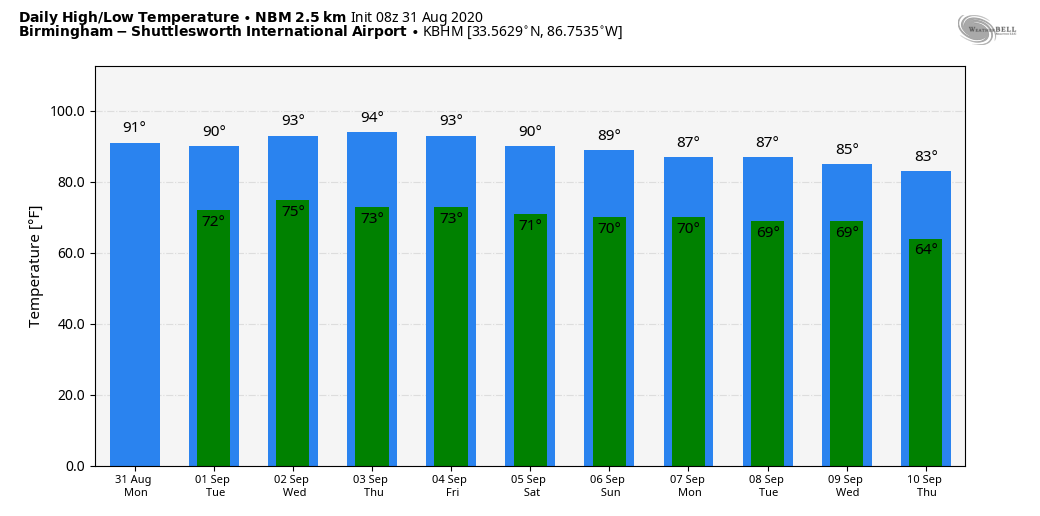
We project a high between 87 and 90 degrees today; the average high for Birmingham on August 31 is 89. We expect a mix of sun and clouds, and once again scattered showers and thunderstorms will fire up this afternoon. Odds of any one place getting wet are about one in two, and some of the storms over North Alabama could be strong. SPC has defined a “marginal risk” (level 1/5) for about the northern half of the state for the afternoon and evening hours.
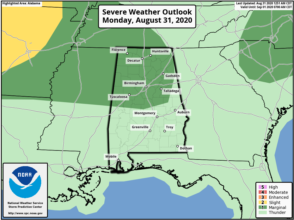
The main threat from the stronger storms will come from straight line winds. Showers and storms will die down tonight once the sun goes down.
We don’t expect much change tomorrow; partly sunny with scattered showers and thunderstorms by afternoon… the high will be close to 90.
WEDNESDAY THROUGH FRIDAY: An upper ridge will strengthen over the region, and our weather trends hotter and drier. Look for partly sunny days, highs in the low to mid 90s, and only isolated showers. Odds of any one spot getting wet on these three days will drop into the 15-25 percent range.
LABOR DAY WEEKEND: Highs will drop back into the mid to upper 80s over the weekend; a few scattered showers or thunderstorms will be possible. For now it looks like the higher coverage will be on Sunday, but it still won’t be a total “wash-out”.
NEXT WEEK: A big pattern change will being a series of cold fronts into Alabama, with potential for a very nice taste of fall over the latter half of the week. Model data suggests highs will drop into the low 80s, with lows in the low 60s. A good chance many North Alabama communities will dip into the 50s based on the projected upper air pattern. See the Weather Xtreme video for maps, graphics, and more details.
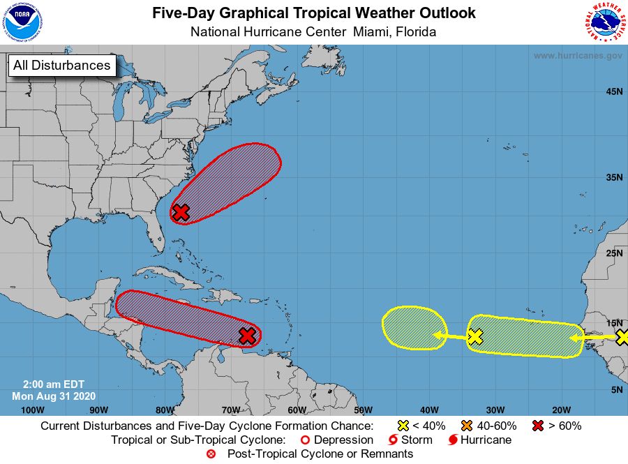
TROPICS: NHC is monitoring four tropical waves this morning. One is over the African continent; it will emerge into the Atlantic by mid-week. Another is in the Central Atlantic between the coast of Africa and the Lesser Antilles. For now both of these have a low chance of development over the next five days.
An area of low pressure (invest 90L) is located a few hundred miles east of Jacksonville, Florida. This system has gradually gotten better organized during the past 24 hours but is currently producing only limited showers and thunderstorms. Additional development is expected and a tropical depression is likely to form by the middle of the week while the system moves northeastward or east-northeastward, initially parallel to the southeastern coast of the U.S. and then away from land. Upper-level winds are expected to become less conducive for further development on Wednesday.
And, recent satellite imagery and satellite-derived wind data indicate that a broad area of low pressure associated with a tropical wave over the eastern Caribbean Sea has changed little in organization since yesterday. However, environmental conditions are expected to gradually become more conducive for development, and a tropical depression is likely to form during the next couple of days while the system moves moves westward at at 15 to 20 mph. It looks like it will move into Central America later this week, where it will likely dissipate.
For now no systems are threatening the U.S. mainland, and the Gulf of Mexico remains quiet.
ON THIS DATE IN 1935: The most intense hurricane to make landfall was a modest tropical depression on this day. Called the Labor Day Hurricane, this storm went through phenomenal intensification to become a Category 5 hurricane by September 2nd.
BEACH FORECAST: Click here to see the AlabamaWx Beach Forecast Center page.
WEATHER BRAINS: Don’t forget you can listen to our weekly 90 minute show anytime on your favorite podcast app. This is the show all about weather featuring many familiar voices, including our meteorologists here at ABC 33/40.
CONNECT: You can find me on all of the major social networks…
Facebook
Twitter
Instagram
Pinterest
Snapchat: spannwx
Look for the next Weather Xtreme video here by 4:00 this afternoon… enjoy the day!
Category: Alabama's Weather, ALL POSTS, Weather Xtreme Videos
About the Author (Author Profile)
James Spann is one of the most recognized and trusted television meteorologists in the industry. He holds the AMS CCM designation and television seals from the AMS and NWA. He is a past winner of the Broadcast Meteorologist of the Year from both professional organizations.Subscribe
If you enjoyed this article, subscribe to receive more just like it.


