

Alabama Trending Hotter/Drier After Today
SCATTERED STORMS LATER TODAY: The radar is quiet early this morning, but scattered showers and thunderstorms will develop in the moist, unstable airmass across Alabama later today and tonight. Most of the showers will come from noon to midnight, and odds of any one spot getting wet are 50/60 percent. Otherwise, look for a partly sunny sky today with a high around 90 degrees. The average high for Birmingham on September 1 is 89.
REST OF THE WEEK: A strengthening upper ridge will bring a trend toward hotter and drier weather to Alabama. Look for mostly sunny days, fair nights, and only isolated afternoon showers. Highs will be in the 91-94 degree range for most communities; a reminder it can be pretty hot around here in September.
LABOR DAY WEEKEND: Not much change Saturday; the sky will be mostly sunny with only a small risk of any one spot seeing a shower. Heat levels come down with a high in the upper 80s. Then, moisture levels slowly rise Sunday and Monday… we will bring in a chance of scattered showers and thunderstorms both days with highs between 85 and 89 degrees. Highest coverage of s showers should come on Monday with a surface front approaching.
NEXT WEEK: Scattered showers and storms remain in the forecast Tuesday and Wednesday, but a nice push of cooler, drier air should roll into Alabama by Thursday and Friday. Model data suggests highs will drop into the low 80s, with lows in the 50s for much of North Alabama by then. A nice reminder that fall weather is close. See the Weather Xtreme video for maps, graphics, and more details.
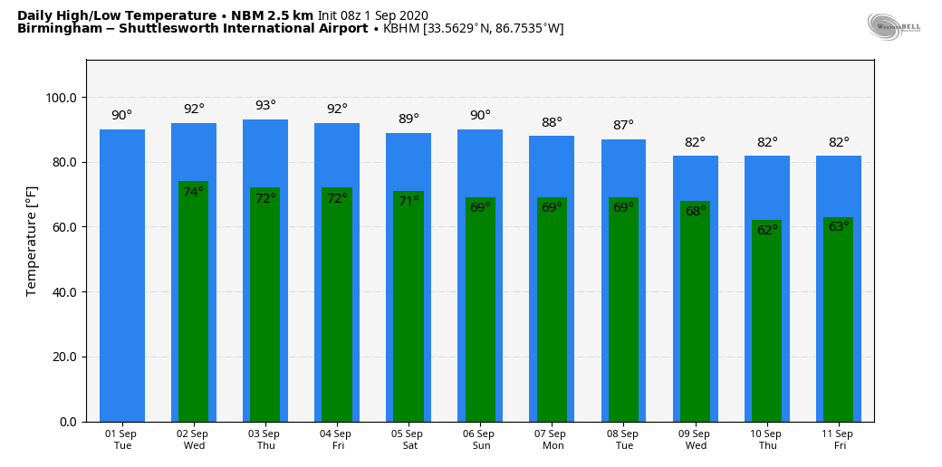
FOOTBALL WEATHER: UAB kicks off their season Thursday night against Central Arkansas (7p CT at Legion Field)… it will be a great night for football. A clear sky; 88 degrees at kickoff, 82 by the final whistle. Light SW wind.
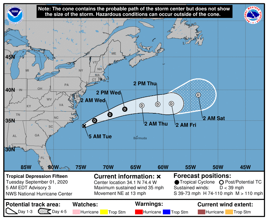
TROPICS: Tropical Depression 15 formed yesterday off the coast of the Carolinas; the latest forecast from NHC suggests the system will remain a tropical depression, and move out into the open Atlantic. Another weak, junk system that is no threat to land.
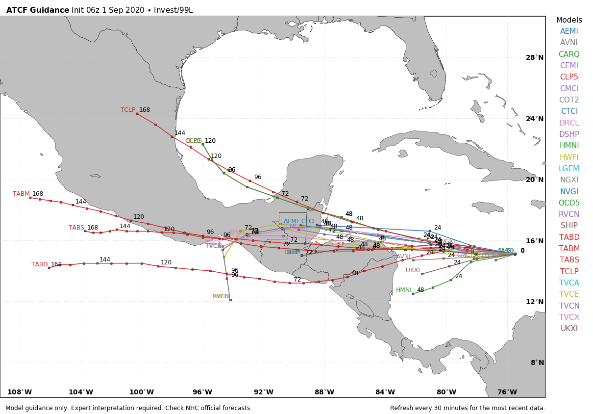
Elsewhere, a seemingly well-organized cluster of showers and thunderstorms associated with a tropical wave is moving quickly westward across the central Caribbean Sea, but satellite-derived wind data from a few hours ago again showed that the system has not developed a closed surface wind circulation. The wave is, however, producing an area of winds near tropical storm force south of the coast of Haiti, which will move near or south of Jamaica later this morning. Environmental conditions are expected to become a little more conducive for development, and a tropical depression is likely to form during the next couple of days before the system reaches Central America tomorrow night. This system will remain south of the Gulf of Mexico.
And, a tropical wave is expected to emerge off the coast of Africa in a day or so. Gradual development of this system will be possible through the end of the week while it moves slowly westward over the far eastern tropical Atlantic Ocean. Way too early to know if this will impact any land mass.
No tropical trouble for the Central Gulf Coast (Gulf Shores to Panama City Beach) for the Labor Day weekend; the weather will be routine with the usual mix of sun and scattered storms.
ON THIS DATE IN 1974: Lt. Judy Neuffer became the first female to fly a Hurricane Hunter aircraft through the eye of a hurricane (Carmen). Carmen moved ashore on the Yucatán Peninsula as a category four hurricane, where, despite striking a sparsely populated region, it caused significant crop damage and killed several people. Landfall then came later on the U.S. coast over southern Louisiana, west of New Orleans. Many Mississippi citizens, having experienced the destruction of Hurricane Camille just five years earlier, quickly left their coastal homes.
BEACH FORECAST: Click here to see the AlabamaWx Beach Forecast Center page.
WEATHER BRAINS: Don’t forget you can listen to our weekly 90 minute show anytime on your favorite podcast app. This is the show all about weather featuring many familiar voices, including our meteorologists here at ABC 33/40.
CONNECT: You can find me on all of the major social networks…
Facebook
Twitter
Instagram
Pinterest
Snapchat: spannwx
Look for the next Weather Xtreme video here by 4:00 this afternoon… enjoy the day!
Category: Alabama's Weather, ALL POSTS, Weather Xtreme Videos
About the Author (Author Profile)
James Spann is one of the most recognized and trusted television meteorologists in the industry. He holds the AMS CCM designation and television seals from the AMS and NWA. He is a past winner of the Broadcast Meteorologist of the Year from both professional organizations.Subscribe
If you enjoyed this article, subscribe to receive more just like it.


